- Coronado National Forest
-
Coronado National Forest IUCN Category VI (Managed Resource Protected Area)

Location Arizona / New Mexico, USA Nearest city Tucson, AZ Coordinates 31°59′47″N 110°18′32″W / 31.99639°N 110.30889°WCoordinates: 31°59′47″N 110°18′32″W / 31.99639°N 110.30889°W Area 1.78 million acres (7,200 km2) Established April 11, 1902 Governing body U.S. Forest Service The Coronado National Forest includes an area of about 1.78 million acres (7,200 km2) spread throughout mountain ranges in southeastern Arizona and southwestern New Mexico.
It is located in parts of Cochise, Graham, Santa Cruz, Pima, and Pinal counties in Arizona, and Hidalgo County in New Mexico.
The National Forest is divided into five ranger districts. The districts themselves are not contiguous; each consists of multiple "sky island" mountain ranges.
The Santa Catalina Ranger District near the city of Tucson comprises the Santa Catalina and Rincon Mountains. Included in this area is the highest peak of the Santa Catalinas, Mount Lemmon, the rugged Pusch Ridge Wilderness Area, and the popular Sabino Canyon. Much of this district was part of Santa Catalina National Forest before its inclusion in Coronado.
The Safford Ranger District comprises the mountain ranges surrounding the city of Safford, Arizona. These five ranges are the Pinaleño, Galiuro, Santa Teresa, Winchester, and Greasewood Mountains. Included in this area is the highest peak of the Pinaleños, Mount Graham. Mount Graham National Forest was a formerly separate national forest, combined into Crook National Forest on July 1, 1908. In 1953 part of Crook was absorbed into Coronado.
The Nogales Ranger District comprises four mountain ranges north and west of Nogales, Arizona. These ranges are the Santa Rita, Tumacacori, Pajarito, and San Luis Mountains. Included in this area are Mount Hopkins, Mount Wrightson, and Madera Canyon, all located in the Santa Ritas. In the early 20th century this area included two national forests which were absorbed into Coronado: Santa Rita National Forest and Tumacacori National Forest.[1]
The Douglas Ranger District comprises three mountain ranges north and east of Douglas, Arizona. These ranges are the Chiricahua, Dragoon, and Peloncillo Mountains. A portion of the Ranger District in the Peloncillos extends into New Mexico. The district comprises three formerly separate national forests: Chiricahua National Forest, Dragoon National Forest and Peloncillo National Forest, all combined into Coronado.[1]
The Sierra Vista Ranger District comprises three mountain ranges west of Sierra Vista, Arizona. These ranges are the Huachuca, Patagonia, and Whetstone Mountains. Included in this area is the highest peak in the Huachucas, Miller Peak, and the region of the Huachucas known as Canelo Hills. The district includes the formerly separate Huachuca National Forest [1]
¡Three Amigos! was partially filmed here in addition to Old Tucson Studios.[citation needed]
Contents
Wilderness
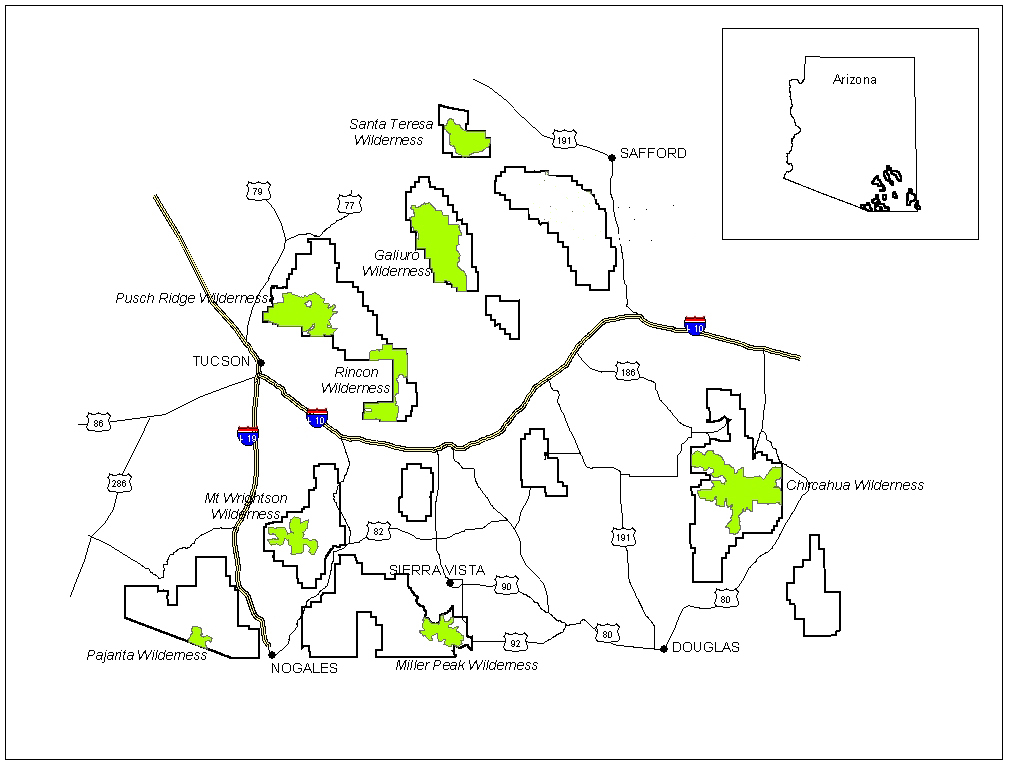
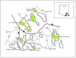 Wilderness areas in the Coronado National Forest
The Coronado National Forest contains eight designated wilderness areas, with at least one in each Ranger District. Congress defines Wilderness as an area "untrammeled by man." Common activities in the Coronado National Forest wilderness areas include hiking, horseback riding, camping, hunting, and fishing. The use of mechanized or motorized equipment, including bicycles, generators, and chain saws, is prohibited.[2]
- Chiricahua Wilderness (Douglas District)
- Galiuro Wilderness (Safford District)
- Miller Peak Wilderness (Sierra Vista District)
- Mount Wrightson Wilderness (Nogales District)
- Pajarita Wilderness (Nogales District)
- Pusch Ridge Wilderness (Santa Catalina District)
- Rincon Wilderness (Santa Catalina District)
- Santa Teresa Wilderness (Safford District)
Campgrounds
Below is a table displaying all public campgrounds located within the Coronado National Forest.[3] Most requiring a daily/nightly fee (see Coronado National Forest official website for accurate and current details), though some do not.
Campground Status * Elevation Fee Mountain Range Arcadia Open 6700 Yes Pinaleño Mountains Bathtub Open 6300 Yes Chiricahua Mountains Bog Springs Open 5200 Yes Santa Rita Mountains Cochise Stronghold Developed sites Closed until Sept 1st.
Dispersed camping is OPEN5000 Yes Dragoon Mountains Cunningham Open 9000 Yes Pinaleño Mountains Cypress Park Open 6000 Yes Chiricahua Mountains General Hitchcock Open 6000 Yes Santa Catalina Mountains Gordon Hirabayashi Open 5000 Yes Santa Catalina Mountains Herb Martyr Open 5800 Yes Chiricahua Mountains Hospital Flat Open 9000 Yes Pinaleño Mountains Idlewilde Open 5000 Yes Chiricahua Mountains John Hands Open 5600 No Chiricahua Mountains Lakeview
(Parker Cyn Lake)Open 5400 Yes Huachuca Mountains
(Canelo Hills)Molino Basin Open 4500 Yes Santa Catalina Mountains Peppersauce Open 4700 Yes Santa Catalina Mountains Pinery Canyon Open 7000 No Chiricahua Mountains Ramsey Vista Open 7400 Yes Huachuca Mountains Reef Townsite Open 7200 Yes Huachuca Mountains Riggs Flat Open 8600 Yes Pinaleño Mountains Rose Canyon Open 7000 Yes Santa Catalina Mountains Rucker Forest Camp Open 6500 Yes Chiricahua Mountains Rucker Lake Open 6300 Yes Chiricahua Mountains Rustler Park Open 8500 Yes Chiricahua Mountains Shannon Open 9100 Yes Pinaleño Mountains Soldier Creek Closed 9300 Yes Pinaleño Mountains Spencer Canyon Open 8000 Yes Santa Catalina Mountains Stewart Open 5100 Yes Chiricahua Mountains Stockton Pass Open 5600 No Pinaleño Mountains Sunny Flat Open 5200 Yes Chiricahua Mountains Sycamore Open 6200 Yes Chiricahua Mountains W Turkey Creek Open 5900 Yes Chiricahua Mountains White Rock Open 4000 Yes Tumacacori Mountains * Information is accurate as of Tuesday, 17 June 2008 at 13:39:50 EDT
Former National Forests
Huachuca National Forest
Huachuca National Forest was established as the Huachuca Forest Reserve by the U.S. Forest Service in Arizona on November 6, 1906 with 314,125 acres (127,122 ha). It became a National Forest on March 4, 1907. On July 1, 1908 the entire forest was combined with Baboquivari National Forest and Tumacacori National Forest to establish Garces National Forest, and the name was discontinued. The lands are presently included in Coronado National Forest.[1]
See also
References
- ^ a b c d Davis, Richard C. (September 29, 2005), National Forests of the United StatesPDF (341 KB), The Forest History Society
- ^ Coronado National Forest Wilderness
- ^ Coronado National Forest - Campground Guide
External links
- Coronado National Forest Web Site
- Forest History Society
- Hikes in the Coronado National Forest at HikeArizona.COM
- Listing of the National Forests of the United States and Their Dates (from Forest History Society website) Text from Davis, Richard C., ed. Encyclopedia of American Forest and Conservation History. New York: Macmillan Publishing Company for the Forest History Society, 1983. Vol. II, pp. 743-788.
Protected Areas of Arizona Federal Gila Box Riparian · Las Cienegas · San Pedro RiparianArizona National Scenic Trail · Juan Bautista de Anza National Historic Trail · Old Spanish National Historic TrailBill Williams River · Buenos Aires · Cabeza Prieta · Cibola · Havasu · Imperial · Kofa · Leslie Canyon · San BernardinoOtherCoronado National Memorial · Elden Pueblo · Glen Canyon National Recreation Area · Lake Mead National Recreation Area · Palatki Heritage Site · V-Bar-V Heritage SiteState Western RegionAlamo Lake · Buckskin Mountain · Cattail Cove · Lake Havasu · River Island · Yuma Quartermaster Depot · Yuma Territorial PrisonNorthern RegionDead Horse Ranch · Fort Verde · Homolovi · Jerome · Red Rock · Riordan Mansion · Slide Rock · Verde River GreenwayEastern RegionBoyce Thompson Arboretum · Catalina · Fool Hollow Lake · Lost Dutchman · Lyman Lake · McFarland · Oracle · Tonto Natural BridgeSouthern RegionKartchner Caverns · Patagonia Lake · Picacho Peak · Roper Lake · San Rafael · Sonoita Creek · Tombstone Courthouse · Tubac PresidioMunicipal Other See List of National Natural Landmarks in ArizonaArizona State Parks (web) Categories:- IUCN Category VI
- National Forests of Arizona
- Protected areas of Pinal County, Arizona
- Protected areas of Cochise County, Arizona
- Protected areas of Graham County, Arizona
- Protected areas of Santa Cruz County, Arizona
- Protected areas of Pima County, Arizona
- Protected areas of Hidalgo County, New Mexico
- National Forests of New Mexico

Wikimedia Foundation. 2010.