- Cibola National Forest
-
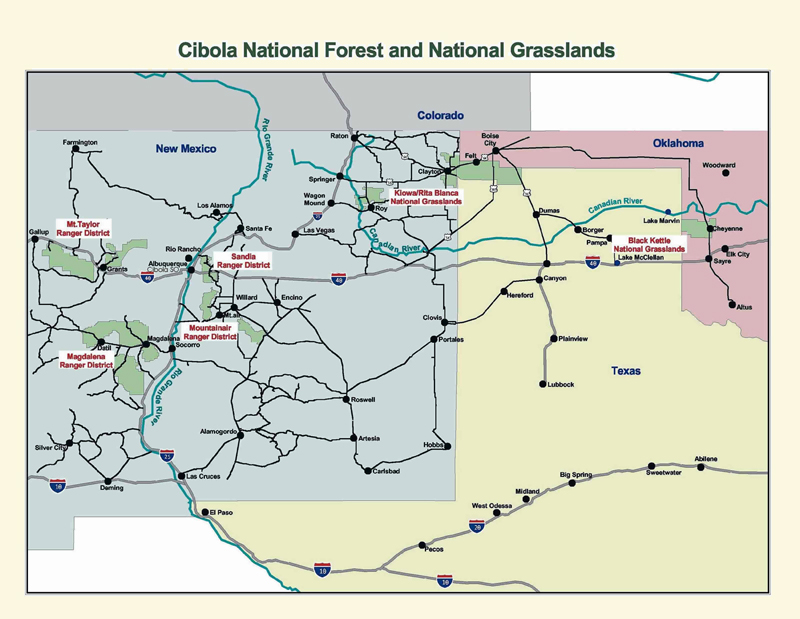
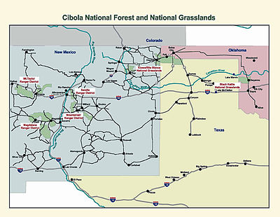 Map of Cibola National Forest.
The Cibola National Forest is a 1,631,266 acres (6,601.5 km2) United States National Forest in western and central New Mexico, USA. [1] The forest also manages four National Grasslands that stretch from northeastern New Mexico eastward into the Texas Panhandle and western Oklahoma. It is administered by the United States Forest Service from offices in Albuquerque, New Mexico. Elevation ranges from 5,000 ft (1,500 m) to 11,301 ft (3,445 m). (The preceding figures do not include any of the four National Grasslands mentioned below, which are detailed in their individual articles.)
The Cibola National Forest is organized into several divisions over three states. The Rita Blanca National Grassland 92,989 acres (376.3 km2) in Dallam County, Texas and Cimarron County, Oklahoma), Black Kettle National Grassland 31,286 acres (126.6 km2) in Roger Mills County, Oklahoma and Hemphill County, Texas), and McClellan Creek National Grassland 1,449 acres (5.9 km2) in Gray County, Texas) are in the Oklahoma-Texas panhandle region.
New Mexico is home to much of the Forest, including the Kiowa National Grassland 136,417 acres (552.1 km2) in Harding, Union, Mora, and Colfax counties, New Mexico). The Sandia Ranger District is in Central New Mexico in eastern Bernalillo and southeastern Sandoval counties, and includes the Sandia Mountains and the Manzanita Mountains. The Sandia Mountain Wilderness is included in this area.
In central New Mexico the Mountainair Ranger District in Torrance, northwestern Lincoln, and eastern Valencia counties, includes the Gallinas Mountains and the Manzano Mountains, including the Manzano Mountain Wilderness. The Mount Taylor Ranger District is in northern Cibola, southern McKinley, and western Sandoval counties in western New Mexico, and includes Mount Taylor and the Zuni Mountains.
The Magdalena Ranger District is in south central New Mexico in western Socorro, northeastern Catron, and northern Sierra counties, and comprises the Bear Mountains, the Datil Mountains, the Magdalena Mountains and the San Mateo Mountains. There are two wilderness areas in this area - the Apache Kid and Withington Wilderness areas.
Not counting the three Grasslands areas, the Cibola National Forest proper is located in descending order of land area in Socorro, Cibola, McKinley, Catron, Torrance, Bernalillo, Sandoval, Lincoln, Sierra, and Valencia counties in New Mexico.
The combined Cibola National Grasslands are 262,141 acres (1,060.8 km2) in size.
Cibola biomes range from Chihuahuan desert to short grass prairie to piñon-juniper to sub-alpine spruce and fir. It offers an abundance of commercial and recreational opportunities including grazing, oil/gas, timber, picnicking, camping, skiing, hiking and mountain biking as well as the aerial Sandia Peak Tramway with a restaurant and skiing at the top. The region also boasts wildlife as diverse as the biomes they inhabit.
Animals represented include:
- bear,
- mountain lion,
- prairie dog,
- mule deer,
- pronghorn antelope,
- Black Rosy Finch and
- wild turkey.
Due to the Rio Grande, a large variety of migrating waterfowl and other birds follow the river's flyway during the spring and fall. Birds of prey are also present using the updrafts and thermals along the north-south alignment of the central mountains for their migration.
Fires
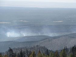 Trigo Fire burning in a canyon
In 2008 the Trigo Fire burned 13,709 acres (55.48 km2) mostly within the Mountainair Ranger District of the Cibola National Forest.
References
- ^ Table 6 - NFS Acreage by State, Congressional District and County - United States Forest Service - September 30, 2007
External links
- official Cibola National Forest website
- Encyclopedia of Oklahoma History and Culture - Black Kettle National Grassland
Categories:- Cibola National Forest
- National Forests of New Mexico
- Protected areas of Bernalillo County, New Mexico
- Protected areas of Sandoval County, New Mexico
- Protected areas of Socorro County, New Mexico
- Protected areas of Cibola County, New Mexico
- Protected areas of McKinley County, New Mexico
- Protected areas of Catron County, New Mexico
- Protected areas of Torrance County, New Mexico
- Protected areas of Lincoln County, New Mexico
- Protected areas of Sierra County, New Mexico
- Protected areas of Valencia County, New Mexico

Wikimedia Foundation. 2010.