- Magdalena Mountains
-
Magdalena Mountains Range 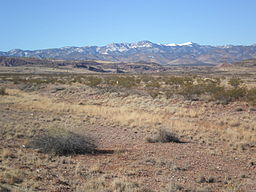 Magdalena Mountains seen from about 10 miles to the east along U.S. Route 60.
Country United States State New Mexico Highest point South Baldy - elevation 10,783 ft (3,287 m) - coordinates 33°59′27″N 107°11′15″W / 33.99083°N 107.1875°W Length 18 mi (29 km), North-South  Location of the Magdalena Mountains within New Mexico
The Magdalena Mountains are a small in area, but regionally high, mountain range in Socorro County, in west-central New Mexico in the southwestern United States. The highest point in the range is South Baldy, at 10,783 ft (3,287 m). The range runs roughly north-south and is about 18 miles (28 km) long. The range lies just south of the community of Magdalena, and about 18 miles (28 km) west of Socorro. The range takes its name from a volcanic peak on the west side, named Magdalena Peak, after Mary Magdalene. A talus formation on the mountain is said to resemble a woman's face.[1]
The Magdalena Mountains are an east-tilted fault-block range, superimposed on Cenozoic calderas. They form part of the western edge of the Rio Grande Rift Valley, fronting the La Jencia Basin. Much mining activity, involving gold, silver, zinc and lead, occurred on the west side of the range between 1866 and 1960.[1] The mines in the vicinity are particularly well known for museum-quality specimens of the zinc carbonate mineral Smithsonite.
Most of the Magdalena Mountains are within the Magdalena Ranger District of the Cibola National Forest, and parts are also administered by the Bureau of Land Management. There are no designated wilderness areas in the range, but there are sizeable (up to approximately 35,000 acre) roadless areas featuring trails and abundant hiking opportunities. There are two Wilderness Study Areas in the southern end of the range.[1][2] At the southern end of the main range crest, just south of South Baldy, lies the Langmuir Laboratory for Atmospheric Research of the New Mexico Institute of Mining and Technology (New Mexico Tech). The same area hosts the Magdalena Ridge Observatory Interferometer, also operated by New Mexico Tech, along with other institutions. A well-established network of trails exists in the Magdalena Mountains. GPS tracks of many hikes, trail runs, and mountain biking routes can be found at the NMT Earth and Environmental Science Department Outdoor Recreation web page and in the Socorro Area Fat Tire Guide.
Significant summits include:[3]
Mountain Height (ft) Height (m) Coordinates Prominence (ft) South Baldy 10,783 3,287 33°59′29″N 107°11′17″W / 33.9913°N 107.1880°W 3,813 Timber Peak 10,510 3,203 33°58′44″N 107°09′37″W / 33.9790°N 107.1603°W 650 North Baldy 9,858 3,005 34°03′01″N 107°10′53″W / 34.0503°N 107.1813°W 554 Buck Peak 9,085 2,769 33°58′58″N 107°07′51″W / 33.9827°N 107.1307°W 625 References
- ^ a b c Butterfield, Mike, and Greene, Peter, Mike Butterfield's Guide to the Mountains of New Mexico, New Mexico Magazine Press, 2006, ISBN 978-0-937206-88-1
- ^ Magdalena Mountains at the New Mexico Wilderness Alliance
- ^ NM peaks on Lists of John
Coordinates: 33°58′20″N 107°11′06″W / 33.9723°N 107.1850°W
Categories:- Mountain ranges of New Mexico
- Cibola National Forest
- Landforms of Socorro County, New Mexico
- Bureau of Land Management areas in New Mexico
- New Mexico geography stubs

Wikimedia Foundation. 2010.