- Oliver Lee Memorial State Park
-
Oliver Lee Memorial State Park New Mexico State Park 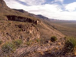 The western escarpment of the Sacramento Mountains, looking south at sunset from the Dog Canyon Trail
Named for: Oliver Lee Country  United States
State  New Mexico
County Otero County Location Alamagordo [1] - elevation 4,363 ft (1,330 m) [1] - coordinates 32°44′48″N 105°54′58″W / 32.74667°N 105.91611°W Area 640 acres (259 ha) Established 1980 [2] Management New Mexico State Parks Division 
 Oliver Lee Memorial State Park
in New MexicoWebsite: Oliver Lee Memorial State Park Oliver Lee Memorial State Park is a state park of New Mexico, USA, in Otero County. The park is 40 acres (16 ha) and sits at an elevation of 4,554 feet (1,388 m).[1] It is situated at the base of Dog Canyon in the Sacramento Mountains, and provides opportunities for camping, hiking, picnicking, wildlife viewing, a nature trail, and a guided tour of Oliver Lee's historic 19th-century ranch house.
The Dog Canyon National Recreational Trail climbs to provide views of the Tularosa Basin and the Organ Mountains. Nearby are the community of Alamogordo and the White Sands National Monument. Oliver Lee Memorial State Park was established in 1980.[2]
Contents
History
Oliver Lee Memorial State Park consists of two separate parcels of land. Both parcels are historically significant. The Dog Canyon tract was used by Apache warriors as a defensive position and a base of operations during their numerous battles and wars with Euro-American explorers and settlers.[2] Oliver Lee's homestead near the mouth of Dog Canyon was built in 1893. Lee was an influential citizen of New Mexico's settlement. The ranch is now a historic site and demonstrates how the ranch home looked while Lee was living there.[2] As a well known rancher Lee was able to use his political influence to bring the railroad to nearby Alamogordo in 1898 and establish financial connections with influential citizens in El Paso, Texas.[2] The second and northern parcel of land, has been studied extensively by archaeologists to determine the cultural history of the area.[2]
Native Americans
Oliver Lee Memorial State Park is situated in the Chihuahuan Desert. The Otero County area of New Mexico receives very little rain with an average yearly rainfall of just 11.6 inches (290 mm).[3] The fact that a perennially flowing stream of water passes through Dog Canyon made it an important location for settlement by Native Americans that lived in, and travelled through the Tularosa Basin.
The earliest known people to live in the area of the park were Paleoindians. They lived in the area from 9500 BC to about 5500 BC. They hunted a variety of now extinct animals like the Mammoth and large Bison.[2] Evidence of their existence at the park include fluted projectile points and evidence of time-period campsites.[2]
The Paleoindians were followed by peoples of the Archaic period from 5500 BC to 200 AD. These people were more sedentary than their the Paleoindians as evidenced by remnants of plant processing. The Archaics hunted animals and gathered plants for food. They were followed during the Formative period 200 - 1400 by the Jornada Mogollon peoples. The Jornada Mogollons were farmers that lived in villages and practiced a combination of dry-land and flood-land agriculture.[2] Archaeologists have found ground stones, ceramics, projectile points, rock pueblo ruins, pithouses and rock art that are consistent with the cultural practices of the Jornada Mogollans.[2]
The Mescalero Apache established their dominance in the Tularosa Basin area by 1400. They were a mobile tribe that lived in tipis and subsisted on foods they both hunted and gathered. They also left behind projectile points. Other evidence of their time in the area includes drills, spears and stone axes. These Apache were the Indians that were encountered by Spanish explorers and later Anglo-American settlers. The Apache were highly territorial and defended their lands from incursion by settlers from Mexico and the southwestern territories of the United States.[2]
Early settlers
The Apache were eventually forced from their lands by the forces of the United States. The Oliver Lee Memorial State Park area saw numerous conflicts between the Apache and Anglo-Americans from 1848 until 1912.[2] The U.S. military and the Mescaleros had many confrontations within Dog Canyon itself over this time period during the Apache Wars.[2]
The first homestead in the area was established by Francois Jean Rochas in 1885.[4] He built his home at the mouth of Dog Canyon. He lived in a two room rock and adobe home. Rochas planted an orchard and built retaining walls on the ridges that flank the canyon. His home is marked by a partly reconstructed cabin on the interpretive trail that is west of the park's visitor center.[2]
The park's namesake, Oliver Milton Lee, arrived in the area from Buffalo Gap, Texas in 1893. He established a 320-acre (130 ha) ranch on land just south of Dog Canyon. Lee built a ranch house, barns, corrals, reservoir and slaughterhouse on his land. He also developed an irrigation system that provided water for his ranch from the stream in the canyon. Remants of the water system can be see at the park.[2] Oliver Lee later held office in the New Mexico Senate and continued operating his ranches until his own death in 1941. He was able to use his political influence to improve the area by bringing the railroad to Alamogordo in 1898.[2]
Lee sold his ranch in 1907. After a series of several owners, the ranch lands were made a part of the White Sands National Monument in 1939. Management of the 440-acre (180 ha) Dog Canyon tract was transferred to the State Parks Division in 1983, three years after the establishment of the parcel to the north of the canyon.[2] Ownership of the southern part of the park was transferred to the state of New Mexico in 1998.[2]
Geology
Oliver Lee Memorial State Park is at the base of the western escarpment of the Sacramento Mountains of New Mexico. It contains Dog Canyon and land to the north of the canyon. The canyon is bisected by a perennial stream, a rarity in the Chihuahuan Desert.[2]
The Sacramento Mountains are a mountain range lying just east of Alamogordo in Otero County (small portions of the range are in Lincoln County and Chaves County). From north to south, the Sacramento Mountains extend for 85 miles (137 km), and from east to west they encompass 42 miles (68 km).[5] Dog Canyon is one of several canyons found on the west side of the mountains. The canyon and cliff faces show the geologic history of the park stretching from the Ordovician times (570 million years ago) to the Permian times (300 million years ago).[2] Evidence of marine life in the area points to a time period when the land was covered by a shallow sea. The rocks contain fossils of nautiloid cephalopods. Native Americans used chert that was left behind as the seas receded to make stone tools.[2] Rocks from the Mississippian age show continental shelf deposits and reef-like remains of fossilized crinoids, bryozoans and dense limestone.[2] The Sacramentos underwent a volcanic time during the Tertiary Period (30 million years ago). The volcanic forces created igneous sills into the rocks from the Devonian Period.[2]
Oliver Lee Memorial State Park is on the edge of the Tularosa Basin. Hydrologically, the Tularosa Basin is a closed basin; no streams flow out. Surface water that doesn’t evaporate or soak into the ground eventually accumulates at intermittent lakes. The basin covers about 6,500 square miles (16,800 km2). It was formed 25 million years ago by faults that caused the surrounding mountains to fall and the basin to sink.[2]
Dog Canyon was carved into the basin fill materials of sand, silt and clay by heavy runoffs of earth and water from the surrounding mountains. The heavy rocks and fast moving waters carved the canyon out over millions of years. Lake Otero was formed by heavy snowmelt and rains during the late Pleistocene. About 20,00 years ago the climate changed. As the temperatures rose Lake Otero began to evaporate. Parts of the ancient lake can be found in Lake Lucero, Alkali Flat playa and the gypsum dunes of White Sands National Monument.[2]
Water, flora and fauna
Water is a vital resource in the Chihuahuan Desert. The stream found in Dog Canyon has created a riparian environment in Oliver Lee Memorial State Park that is unique for the area. The stream is kept flowing by rain and snow-melt. The water seeps up from the ground in springs that naturally occur in the limestone formations of the park. The stream dries out just to the just of the park and the remaining water flows underground. It supports a small variety of insects and amphibians, but no fish.[2]
Trees found along the stream include Rio Grande Cottonwood (Populus deltoides wislizeni), New Mexico Locust (Robinia neomexicana), and Velvet Ash (Fraxinus velutina). In the areas away from the stream One-seeded Juniper (Juniperus monosperma), Desert Willow (Chilopsis linearis) and Netleaf Hackberry (Celtis reticulata) are found. Shrubs of the park include Four-wind Saltbush (Atriplex canescens) and Creosote Bush (Larrea tridentata. Wild grapes (Vitis arizonica) and Western Poison Ivy (Toxicodendron rydbergii) can be found in the cool and wetter parts of Dog Canyon.[2] A variety of cacti species can be found in the park including Strawberry Hedgehog (Echinocereus fendleri), Cane Cholla (Opuntia imbricata) and numerous prickly pears (Opuntia spp.). Aquatic plants like Cattail (Typha angustifolia), Giant Helleborine (Epipactis gigantea) and Maidenhair Fern (Adiantum capillus-veneris) are sustained by the stream that flows through the canyon.[2][6] A botanical resource list is provided by the park staff.[2]
Oliver Lee Memorial State Park is home to mammals that are typically found in the upper Chihuahuan Desert. They include Collared Peccary, Ground squirrels, Mule Deer, Black-tailed Jackrabbit and the Desert Cottontail. These are prey to predators like American Black Bears, Cougars, and Bobcats. American Badgers, North American Porcupines, Raccoon, White-nosed Coati and several species of bats and skunks are also found in the desert of the park.[2] Two species of rattlesnakes are found in the park, Western Diamondback and Black-tail. Several species of lizards, skinks, geckos, turtles, and non-venomous snakes can be found in the park. The Texas horned lizard, which is threatened by loss of habitat, pesticides and development in Texas and Oklahoma, is thriving in the park. The horned lizards are legally protected in the park and throughout New Mexico.[2] Known amphibians found in the park include salamanders and toads.[2] The park is also home to birds such as Turkey Vultures, Red-tailed Hawks, Mourning Doves, hummingbirds, warblers and wrens.[2]
Recreation
Oliver Lee Memorial State Park is open for year-round recreation. Recreational opportunities include hiking, camping, picnicking and wild life viewing.[3] There are three trails at the park. Dog Canyon Trail begins at the visitor center and climbs the canyon walls over a distance of 5.5 miles (8.9 km) and rising 3,144 feet (958 m).[2] At the top of the canyon the trail enters the neighboring Lincoln National Forest. Two interpretive trails at the park allow visitors to access the riparian environment along the stream in the canyon and the Oliver Lee Ranch House.[2] There are 44 campsites at the park, 16 of which have electric hookups.[6] Picnic ares are available in various locations of the park.[6]
References
- ^ a b c "Oliver Lee State Park". Geographic Names Information System. United States Geological Survey. August 31, 1992. http://geonames.usgs.gov/pls/gnispublic/f?p=gnispq:3:::NO::P3_FID:1987905. Retrieved 2010-07-16.
- ^ a b c d e f g h i j k l m n o p q r s t u v w x y z aa ab ac ad ae af ag ah ai "Oliver Lee Memorial State Park: Management and Development Plan" (pdf). New Mexico Energy, Minerals and Natural Resources Department. http://www.emnrd.state.nm.us/PRD/documents/OliverLeeStatePark.pdf. Retrieved 2010-07-20.
- ^ a b "Oliver Lee Memorial State Park". New Mexico Engery, Mineral and Natural Resources Department. http://www.emnrd.state.nm.us/PRD/oliverlee.htm. Retrieved 2010-07-20.
- ^ "Oliver Lee Memorial State Park Photo Tour". New Mexico Energy, Minerals and Natural Resources Department. http://www.emnrd.state.nm.us/PRD/oliverleephototour.htm. Retrieved 2010-07-20.
- ^ "Sacramento Mountains". Geographic Names Information System. United States Geological Survey. November 30, 1990. http://geonames.usgs.gov/pls/gnispublic/f?p=gnispq:3:::NO::P3_FID:920683. Retrieved 2010-07-20.
- ^ a b c "Oliver Lee Memorial State Park brochure". New Mexico Energy, Minerals and Natural Resources Department. http://www.emnrd.state.nm.us/PRD/documents/OliverLeeBrochureUpdated07.pdf. Retrieved 2010-07-21.
External links
Categories:- Chihuahuan Desert
- New Mexico state parks
- Parks in Otero County, New Mexico
- Protected areas established in 1980


Wikimedia Foundation. 2010.