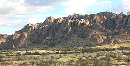
- Dragoon Mountains
-
Dragoon Mountains Mountain Range Dragoon Mountains viewed from the south.Country United States State Arizona Region Madrean Sky Islands District Cochise County Highest point Mount Glenn - elevation 7,520 ft (2,292 m) Length 43 mi (69 km), North to South Width 35 mi (56 km), East to West Extent includes low land hills and valleys[1]
Dragoon Mountains Coordinates: 31°53′N 109°59′W / 31.883°N 109.983°WCoordinates: 31°53′N 109°59′W / 31.883°N 109.983°W Area - Total 2,385.4 km2 (921 sq mi) Dragoon Mountains are a range of mountains located in Cochise County, Arizona. The range is about 25 mi (40 km) long, running on an axis extending south-south east through Willcox.
Contents
Geography
The mountain range is one of Arizona's "sky islands". Mt. Glenn (7,520 ft/2,292 m) is highest point in the Dragoon Mountains. The Little Dragoon Mountains are the continuation of the Dragoon Mountains north of Texas Canyon. The mountains were included in the short-lived Dragoon National Forest, which was established in 1907 and combined into Coronado National Forest in 1908, in the Douglas Ranger District.
History
The warrior Cochise and his army defeated a small force of Confederate soldiers here at the First Battle of Dragoon Springs but was defeated at the Second Battle of Dragoon Springs a few days later. Cochise Stronghold Memorial Park lies near Mt. Glen on the eastern slope of the range and the historic town of Tombstone can be found at the southwestern portion of the range. There are also several ghost towns in the Dragoon Mountains including Gleeson and Courtland.
During the Earp Vendetta Ride in 1882, Wyatt Earp and his posse captured, tortured and executed a native named "Indian Charlie" Cruz in these mountains for his involvement in the death of Morgan Earp.
References
External links
Categories:- Madrean Sky Islands mountain ranges
- Landforms of Cochise County, Arizona
- Mountain ranges of Arizona
- Cochise County conflict
- Arizona geography stubs
Wikimedia Foundation. 2010.


