- Mount Hopkins (Arizona)
-
Mount Hopkins 
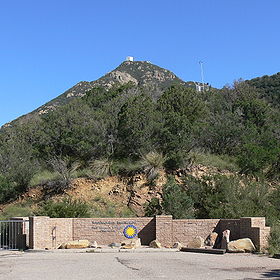
Summit of Mount Hopkins from the entrance to the Fred Lawrence Whipple Observatory that has two locations, one at the bottom of the mountains and the second (this one) located on the slopes of Mount Hopkins.Elevation 8,585 ft (2,617 m) Location Location Santa Cruz County, Arizona, USA Range Santa Rita Mountains Coordinates 31°41′18″N 110°53′05″W / 31.68833°N 110.88472°WCoordinates: 31°41′18″N 110°53′05″W / 31.68833°N 110.88472°W Topo map USGS Mount Hopkins Mount Hopkins is a mountain in Santa Cruz County, Arizona part of the Santa Rita Mountains range. Fred Lawrence Whipple Observatory is located on it. It is within the Coronado National Forest and was named after Gilbert Hopkins who was killed nearby in 1865 during the Battle of Fort Buchanan.
Categories:- Mountains of Arizona
- Landforms of Santa Cruz County, Arizona
- Arizona geography stubs
Wikimedia Foundation. 2010.
