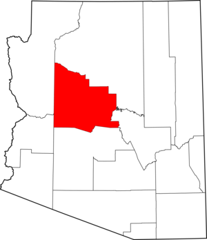
- Yavapai County, Arizona
Infobox U.S. County
county = Yavapai County
state = Arizona

map size = 175
founded = 1865
seat = Prescott | area_total_sq_mi =8128
area_land_sq_mi =8123
area_water_sq_mi =4
area percentage = 0.06%
census yr = 2007
pop = 212,635
density_km2 =8
web = www.co.yavapai.az.us
|Yavapai County is located near the center of the
U.S. state ofArizona . As of 2007, its population was estimated to be 212,635, an increase of 45,118 people since the 2000 census count of 167,517" [http://www.census.gov/population/www/estimates/metro_general/2007/CBSA-EST2007-01.csv] ." "United States Census Bureau ." Retrieved onApril 5 ,2008 ] . Thecounty seat is Prescott.GR|6History
Yavapai County was the one of four original Arizona Counties created by the
1st Arizona Territorial Legislature . The county territory was defined as being east of latitude 113° 20' and north of theGila River . [cite book | last = Wagoner | first = Jay J. | title = Arizona Territory 1863-1912: A Political history | publisher = University of Arizona Press | location = Tucson | date = 1970 | isbn=0-8165-0176-9 | pages= p. 58] . Soon thereafter, the counties of Apache, Coconino, Maricopa, and Navajo were carved from the original Yavapai County. Yavapai County's present boundaries were established in 1891.The county is named after the
Yavapai people , who were the principal inhabitants at the time that this area was annexed by the United States.Geography
According to the U.S. Census Bureau, the county has a total area of 8,128
square mile s (21,051km² ), of which, 8,123 square miles (21,039 km²) of it is land and 4 square miles (12 km²) of it (0.06%) is water. For comparison, Yavapai County has about 93% of the area of the U.S. state ofNew Jersey .The county's topography makes a dramatic transition from the lower
Sonoran Desert to the south to the heights of theCoconino Plateau to the north, and theMogollon Rim to the east.Major Highways
*
*
*
*
*
*
*
*
*Adjacent Counties
*
Mohave County, Arizona - west
*La Paz County, Arizona - southwest
*Maricopa County, Arizona - south
*Gila County, Arizona - east
*Coconino County, Arizona - north/northeastNational
protected area s*
Agua Fria National Monument
*Coconino National Forest (part)
*Kaibab National Forest (part)
*Montezuma Castle National Monument
*Prescott National Forest (part)
*Tonto National Forest (part)
*Tuzigoot National Monument Land ownership and management
*Private ownership: about 25% of Yavapai County's land (by area) is privately owned.
*
Public land : about 75% of the county's area is publicly owned, including:*Federal ownership: about 50% of the county's area is owned by theFederal government of the United States , including::*National Forest lands, managed by theUS Forest Service : 38% of the county's area::*Federal lands managed by the U.S.Bureau of Land Management : 11.6% of the county's area::*Small areas of Federal land are managed by the U.S.Bureau of Indian Affairs and theNational Park Service : less than 0.5% of the county's area.:*About 25% of Yavapai County is owned by theState of Arizona as state trust lands, managed by theArizona State Land Department .Source: [http://www.azcommerce.com/doclib/commune/yavapai%20county.pdf Yavapai County Profile]
Demographics
As of the
census GR|2 of 2000, there were 167,517 people, 70,171 households, and 46,733 families residing in the county. Thepopulation density was 21 people per square mile (8/km²). There were 81,730 housing units at an average density of 10 per square mile (4/km²). The racial makeup of the county was 91.89% White, 0.39% Black or African American, 1.60% Native American, 0.51% Asian, 0.08% Pacific Islander, 3.58% from other races, and 1.95% from two or more races. 9.78% of the population were Hispanic or Latino of any race.There were 70,171 households out of which 23.80% had children under the age of 18 living with them, 55.00% were married couples living together, 8.10% had a female householder with no husband present, and 33.40% were non-families. 26.70% of all households were made up of individuals and 12.40% had someone living alone who was 65 years of age or older. The average household size was 2.33 and the average family size was 2.79.
In the county the population was spread out with 21.10% under the age of 18, 7.10% from 18 to 24, 22.40% from 25 to 44, 27.40% from 45 to 64, and 22.00% who were 65 years of age or older. The median age was 44 years. For every 100 females there were 96.20 males. For every 100 females age 18 and over, there were 93.50 males.
The median income for a household in the county was $34,901, and the median income for a family was $40,910. Males had a median income of $30,738 versus $22,114 for females. The
per capita income for the county was $19,727. About 7.90% of families and 11.90% of the population were below thepoverty line , including 15.90% of those under age 18 and 6.70% of those age 65 or over.By 2006 Census Bureau Estimates placed the population of Yavapai County at 208,014. This represented a 24.2% growth in the population since 2000. [ [http://quickfacts.census.gov/qfd/states/04/04025.html Yavapai County QuickFacts from the US Census Bureau ] ]
Yavapai County is defined as the Prescott
Metropolitan Statistical Area by theUnited States Census Bureau [cite web | url = http://www.whitehouse.gov/omb/bulletins/fy2007/b07-01.pdf | title = OMB Bulletin No. 07-01: Update of Statistical Area Definitions and Guidance on Their Uses | format =PDF | publisher =United States Office of Management and Budget | date =2006-12-18 | accessdate = 2007-04-09]Communities
Cities
*Cottonwood
*Peoria (most of Peoria is in Maricopa County)
*Prescott
*Sedona (part of Sedona is in Coconino County)Towns
*Camp Verde
*Chino Valley
*Clarkdale
*Dewey-Humboldt
*Jerome
*Prescott ValleyCensus-designated places
*Ash Fork
*Bagdad
*Big Park
*Black Canyon City
*Congress
*Cordes Lakes
*Cornville
*Cottonwood-Verde Village
*Lake Montezuma
*Mayer
*Paulden
*Peeples Valley
*Seligman
*Spring Valley
*Wilhoit
*Williamson
*YarnellOther communities
*Bumble Bee
*Cherry
*Cleator
*Clemenceau
*Cordes
*Crown King
*Drake
*Iron Springs
*Kirkland
*Skull Valley
*Tip TopAttractions
Yavapai County is home to
Arcosanti , a prototypearcology , developed byPaolo Soleri , and under construction since 1970. Arcosanti is open Monday through Sunday from 9:00 til 5:00, and holds tours from 10:00 til 4:00 on the hour, every hour. Arcosanti is just north ofCordes Junction, Arizona .Out of Africa Wildlife Park [http://www.outofafricapark.com/] is a popular private zoo that specializes in big cats, and features Tiger Splash [http://www.outofafricapark.com/tiger_splash.html] , an aquatic performance in aswimming pool , and other animal acts. The park moved to theCamp Verde area from theEast Valley in 2005.Approximately convert|10|mi|km|0|sing=off northwest of the town of Bagdad lies the Upper Burro Creek Wilderness Area, a convert|27440|acre|km2|0|sing=on protected area home to at least 150 species of birds and featuring one of the Arizona desert's few undammed perennial streams. [ [http://www.wilderness.net/index.cfm?fuse=NWPS&sec=wildView&wname=Upper%20Burro%20Creek%20Wilderness Upper Burro Creek Wilderness] - Wilderness.net]
References
Further reading
*Fuis, G.S. (1996). "The geology and mechanics of formation of the Fort Rock dome, Yavapai County, Arizona" [U.S. Geological Survey Professional Paper 1266] . Washington, D.C.: U.S. Department of the Interior, U.S. Geological Survey.
External links
* [http://www.azcommerce.com/doclib/commune/yavapai%20county.pdf Yavapai County Profile] by [http://www.azcommerce.com/ Arizona Department of Commerce]

Wikimedia Foundation. 2010.