- Ash Fork, Arizona
Infobox Settlement
official_name = Ash Fork, Arizona
settlement_type = CDP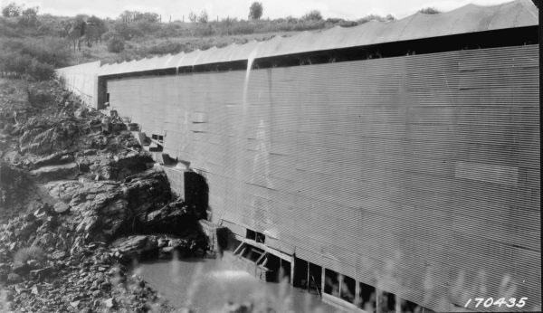
imagesize = 250px
image_caption = US Forest Service photo of theAshfork-Bainbridge Steel Dam taken in 1922.
image_
mapsize = 250px
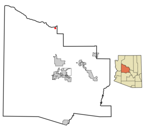
map_caption = Location inYavapai County and the state ofArizona
mapsize1 =
map_caption1 =
subdivision_type = Country
subdivision_type1 = State
subdivision_type2 = County
subdivision_name =United States
subdivision_name1 =Arizona
subdivision_name2 = Yavapai
government_type =
leader_title =
leader_name =
established_date =
area_magnitude =
area_total_km2 = 6
area_total_sq_mi = 2.3
area_land_km2 = 5.9
area_land_sq_mi = 2.3
area_water_km2 = 0.0
area_water_sq_mi = 0.0
elevation_ft = 5160
elevation_m = 1573
population_as_of = 2000
population_footnotes =
population_total = 457
population_metro =
population_density_km2 = 76.9
population_density_sq_mi = 199.1
timezone = MST
utc_offset = -7
latd = 35 |latm = 13 |lats = 16 |latNS = N
longd = 112 |longm = 29 |longs = 14 |longEW = W
timezone_DST =
utc_offset_DST =
postal_code_type =ZIP code
postal_code = 86320
area_code = 928
blank_name = FIPS code
blank_info = 04-04440
blank1_name = GNIS feature ID
blank1_info = 0025794
footnotes =
website =Ash Fork is a
census-designated place (CDP) in Yavapai County,Arizona ,United States . The population was 457 at the 2000 census.Geography
Ash Fork is located at coor dms|35|13|16|N|112|29|14|W|city (35.221236, -112.487100)GR|1.
According to the
United States Census Bureau , the CDP has a total area of 2.3 square miles (6.0 km²), all of it land.Geologic places of interest to visit include
Cathedral Caverns which are approximately convert|10|mi|km west of town off Arizona Road, andDante's Descent , a convert|380|ft|m|sing=on deep sinkhole that is also known as Devil's Hole, which is approximately five miles north west of town off Crookton Road.Approximately convert|15|mi|km to the north of Ash Fork is Beale Road, which has the distinction of being the first federally funded highway.
History
The town was purportedly named in 1882 by F.W. Smith, General Superintendent of the old Atlantic and Pacific Railroad, because of ash trees at the site. The first official post office was established April 12, 1883, with one Henry W. Kline serving as the first Postmaster. [Barnes, Will C.; Granger, Byrd (ed.) Arizona Place Names University of Arizona Press. 1997. P. 30 ] In later years, Ash Fork was the location of the Escalante, a large hotel and "
Harvey House " built in 1907 and closed in 1948, operated by theFred Harvey Company . Ash Fork's convenient location along the railway and later famousU.S. Route 66 made it recognizable to many cross-country travelers, as evidenced by its fleeting mention in several films from the era ofClassical Hollywood cinema , such as 1947's Dark Passage starringHumphrey Bogart andLauren Bacall . Certain areas of the town were also selected to be used as sets in the filming of 1992's Universal Soldier, supposedly due to the extremely low purchase price of several buildings, including an old motel, which were blown up for cinematic effect.The
Ashfork-Bainbridge Steel Dam is located outside of Ash Fork.Demographics
As of the
census GR|2 of 2000, there were 457 people, 149 households, and 109 families residing in the CDP. Thepopulation density was 199.1 people per square mile (76.7/km²). There were 189 housing units at an average density of 82.3/sq mi (31.7/km²). The racial makeup of the CDP was 96.28% White, 1.31% Native American, 1.53% from other races, and 0.88% from two or more races. 51.42% of the population were Hispanic or Latino of any race.There were 149 households out of which 35.6% had children under the age of 18 living with them, 54.4% were married couples living together, 6.7% had a female householder with no husband present, and 26.2% were non-families. 22.1% of all households were made up of individuals and 10.1% had someone living alone who was 65 years of age or older. The average household size was 3.07 and the average family size was 3.45.
In the CDP the population was spread out with 28.7% under the age of 18, 13.6% from 18 to 24, 25.2% from 25 to 44, 21.4% from 45 to 64, and 11.2% who were 65 years of age or older. The median age was 34 years. For every 100 females there were 161.1 males. For every 100 females age 18 and over, there were 143.3 males.
The median income for a household in the CDP was $30,893, and the median income for a family was $36,875. Males had a median income of $23,854 versus $21,094 for females. The
per capita income for the CDP was $11,802. About 16.5% of families and 20.4% of the population were below thepoverty line , including 27.1% of those under age 18 and 18.4% of those age 65 or over.References
External links
Wikimedia Foundation. 2010.