- Tumacacori-Carmen, Arizona
Infobox Settlement
official_name = Tumacacori-Carmen, Arizona
settlement_type = CDP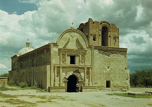
imagesize = 300px
image_caption =Tumacacori mission , 1947. Photo:George A. Grant 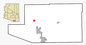
mapsize = 250px
map_caption = Location in Santa Cruz County and the state ofArizona
mapsize1 =
map_caption1 =
subdivision_type = Country
subdivision_type1 = State
subdivision_type2 = County
subdivision_name =United States
subdivision_name1 =Arizona
subdivision_name2 = Santa Cruz
established_title =
established_date =
government_type =
leader_title =
leader_name =
area_magnitude =
area_total_km2 = 16.1
area_total_sq_mi = 6.2
area_land_km2 = 16.1
area_land_sq_mi = 6.2
area_water_km2 = 0.0
area_water_sq_mi = 0.0
elevation_ft =
elevation_m =
population_as_of = 2000
population_footnotes =
population_total = 569
population_density_km2 = 35.3
population_density_sq_mi = 91.8
timezone = MST (no DST)
utc_offset = -7
latd = 31 |latm = 33 |lats = 40 |latNS = N
longd = 111 |longm = 2 |longs = 52 |longEW = W
website =
timezone_DST =
utc_offset_DST =
postal_code_type =
postal_code =
area_code =
blank_name = FIPS code
blank_info = 04-77367
blank1_name =
blank1_info =
footnotes =Tumacacori-Carmen is a
census-designated place (CDP) in Santa Cruz County,Arizona ,United States . The population was 569 at the 2000 census.History
Tumacacori is the site of a Franciscan mission that was built in the late 1700s. It takes its name from an earlier mission site founded by Father
Eusebio Kino in 1691, which is on the east side of the river south of the National Park. This Kino-period mission was founded at an extant native O'odham or Sobaipuri settlement and represents the first mission in southern Arizona, but not the first mission in Arizona. The remains of the native settlement are still extant and have been investigated and reported on by archaeologist Deni Seymour.The later Franciscan mission, which is now a ruin presrved as
Tumacácori National Historical Park , was never rebuilt after being abandoned after repeatedApache raids in the 1800s that killed farmers and ranchers in the area and put a stop to the growth of the area's economy.Geography
Tumacacori-Carmen is located at coor dms|31|33|40|N|111|2|52|W|city (31.561157, -111.047810)GR|1.
According to the
United States Census Bureau , the CDP has a total area of 6.2square mile s (16.1km² ), all of it land. The locale is in a valley cut by theSanta Cruz River .Demographics
As of the
census GR|2 of 2000, there were 569 people, 223 households, and 152 families residing in the CDP. Thepopulation density was 91.6 people per square mile (35.4/km²). There were 252 housing units at an average density of 40.6/sq mi (15.7/km²). The racial makeup of the CDP was 76.98% White, 0.18% Black or African American, 1.05% Native American, 1.58% Asian, 17.57% from other races, and 2.64% from two or more races. 58.00% of the population were Hispanic or Latino of any race.There were 223 households out of which 26.5% had children under the age of 18 living with them, 52.9% were married couples living together, 9.9% had a female householder with no husband present, and 31.8% were non-families. 27.8% of all households were made up of individuals and 9.9% had someone living alone who was 65 years of age or older. The average household size was 2.55 and the average family size was 3.13.
In the CDP the population was spread out with 23.7% under the age of 18, 7.7% from 18 to 24, 26.0% from 25 to 44, 28.6% from 45 to 64, and 13.9% who were 65 years of age or older. The median age was 41 years. For every 100 females there were 96.9 males. For every 100 females age 18 and over, there were 96.4 males.
The median income for a household in the CDP was $35,938, and the median income for a family was $36,250. Males had a median income of $26,806 versus $18,594 for females. The
per capita income for the CDP was $18,607. About 10.1% of families and 10.8% of the population were below thepoverty line , including none of those under age 18 and 26.3% of those age 65 or over.ee also
*
Mission San José de Tumacácori
*Sonoita Creek
*Mexican period of Arizona References
*Di Peso, Charles C. "The Upper Pima of San Cayetano del Tumacacori: An Archaeohistorical Reconstruction of the Ootam of Pimeria Alta," Dragoon: Amerind Foundation, 1956
*Dobyns, Henry F. "Tubac Through Four Centuries: A Historical Resume and Analysis." Prepared for the Arizona State Parks Board 15 March 1959, Reformatted by Tubac Presidio State Historical Park, August 1995 and revised. Available on line at http://parentseyes.arizona.edu/tubac/index.html.*Doyel, D. E. "Excavations in the Middle Santa Cruz River Valley, Southeastern Arizona." Contribution to Highway Salvage Archaeology in "Arizona", Number 44. Tucson: Arizona State Museum, U of Arizona, 1977.
*Seymour, Deni J.::* "Piman Settlement Survey in the Middle Santa Cruz River Valley, Santa Cruz County, Arizona," report submitted to Arizona State Parks in fulfillment of survey and planning grant contract requirements, 1993.:* "Delicate Diplomacy on a Restless Frontier: Seventeenth-Century Sobaípuri Social And Economic Relations in Northwestern New Spain, Part I." New Mexico Historical Review, Volume 82, no. 4, 2007.
:* [http://www.springerlink.com.ezproxy2.library.arizona.edu/content/w43p168015123202/fulltext.html "A Syndetic Approach to Identification of the Historic Mission Site of San Cayetano del Tumacácori."] International Journal of Historical Archaeology, Vol. 11(3):269-296, 2007.
:* "Delicate Diplomacy on a Restless Frontier: Seventeenth-Century Sobaípuri Social And Economic Relations in Northwestern New Spain, Part II." New Mexico Historical Review, Volume 83, no. 2, 2008.
External links

Wikimedia Foundation. 2010.