- Tubac, Arizona
Infobox Settlement
official_name = Tubac, Arizona
settlement_type = CDP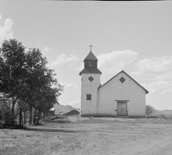
imagesize = 300px
image_caption = St. Ann's Church, Tubac, 1937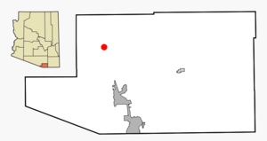
mapsize = 250px
map_caption = Location in Santa Cruz County and the state ofArizona
mapsize1 =
map_caption1 =
subdivision_type = Country
subdivision_type1 = State
subdivision_type2 = County
subdivision_name =United States
subdivision_name1 =Arizona
subdivision_name2 = Santa Cruz
established_title =
established_date =
government_type =
leader_title =
leader_name =
area_magnitude =
area_total_km2 = 21.2
area_total_sq_mi = 8.2
area_land_km2 = 21.2
area_land_sq_mi = 8.2
area_water_km2 = 0.0
area_water_sq_mi = 0.0
elevation_ft = 3209
elevation_m = 978
population_as_of = 2000
population_footnotes =
population_total = 949
population_density_km2 = 44.8
population_density_sq_mi = 115.7
timezone = MST (no DST)
utc_offset = -7
latd = 31 |latm = 37 |lats = 32 |latNS = N
longd = 111 |longm = 3 |longs = 7 |longEW = W
website =
timezone_DST =
utc_offset_DST =
postal_code_type =ZIP code s
postal_code = 85640, 85646
area_code = 520
blank_name = FIPS code
blank_info = 04-75940
blank1_name = GNIS feature ID
blank1_info = 0035489
footnotes =Tubac is a
census-designated place (CDP) in Santa Cruz County,Arizona ,United States . The population was 949 at the 2000 census. The name is a Spanish corruption of O'odham phrase "s-cuk baʼa", or perhaps "cu wa", meaning "black water" or "low place", respectively [ [http://www.tubacaz.com/history.asp Tubac Chamber of Commerce] ] Tubac is situated on theSanta Cruz River .Tubac was the original Spanish colonial garrison in Arizona. It was depopulated during the
O'odham Uprising in theeighteenth century . During thenineteenth century , the area was repopulated by miners, farmers and ranchers, but the town of Tubac is best known today as anartists' colony .Geography
Tubac is located at coor dms|31|37|32|N|111|3|7|W|city (31.625462, -111.051921)GR|1.
According to the
United States Census Bureau , the CDP has a total area of 8.2square mile s (21.2km² ), all of it land.History
Established in 1752 as a Spanish
presidio , the first Spanish colonial garrison in what is nowArizona , Tubac was one of the stops on theCamino Real (the "Royal Road") from Mexico to the Spanish settlements inCalifornia .Tubac's most famous Spanish resident was
Juan Bautista de Anza . While stationed at Tubac (1760-1776), de Anza built the chapel of Santa Gertrudis, the foundations of which lie beneath today's St. Ann's Church.California gambler and highwayman
Jack Powers was murdered in Mexico in November 1860, south of Nogales, and his body fed to a pen of starving hogs. The uneaten part of his corpse was buried in the Arizona Territory south of Tubac. [Walker A. Tompkins, "Santa Barbara History Makers". McNally & Loftin, 1983. p. 105. ISBN 0-87461-059-1]Attractions
The remains of the old Spanish presidio are preserved by
Tubac Presidio State Historic Park . The park also features a regional museum, an underground archeology display, and other historic buildings.Demographics
As of the
census GR|2 of 2000, there were 949 people, 481 households, and 303 families residing in the CDP. Thepopulation density was 115.9 people per square mile (44.8/km²). There were 569 housing units at an average density of 69.5/sq mi (26.9/km²). The racial makeup of the CDP was 88.72% White, 1.16% Native American, 0.42% Asian, 8.96% from other races, and 0.74% from two or more races. 18.23% of the population were Hispanic or Latino of any race.There were 481 households out of which 12.5% had children under the age of 18 living with them, 59.3% were married couples living together, 2.9% had a female householder with no husband present, and 36.8% were non-families. 32.6% of all households were made up of individuals and 21.0% had someone living alone who was 65 years of age or older. The average household size was 1.97 and the average family size was 2.45.
In the CDP the population was spread out with 12.3% under the age of 18, 2.5% from 18 to 24, 12.1% from 25 to 44, 37.8% from 45 to 64, and 35.2% who were 65 years of age or older. The median age was 58 years. For every 100 females there were 92.5 males. For every 100 females age 18 and over, there were 89.5 males.
The median income for a household in the CDP was $39,444, and the median income for a family was $59,375. Males had a median income of $36,528 versus $30,268 for females. The
per capita income for the CDP was $46,643. About 2.1% of families and 6.6% of the population were below thepoverty line , including none of those under age 18 and 7.9% of those age 65 or over.References
External links
* [http://www.tubacaz.com/ Tubac, Arizona; Chamber of Commerce]
* [http://www.pr.state.az.us/parks/parkhtml/tubac.html Tubac Presidio State Historic Park]
* [http://parentseyes.arizona.edu/tubac/ History of Tubac] , prepared forArizona State Parks

Wikimedia Foundation. 2010.