- National Register of Historic Places listings in Yavapai County, Arizona
-
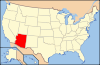
 Location of Yavapai County in Arizona
This is a list of the National Register of Historic Places listings in Yavapai County, Arizona. It is intended to be a complete list of the properties and districts on the National Register of Historic Places in Yavapai County, Arizona, United States. The locations of National Register properties and districts for which the latitude and longitude coordinates are included below, may be seen in a Google map.[1]
There are 131 properties and districts listed on the National Register in the county, including 1 that is also a National Historic Landmark. 71 of these properties and districts are located in the city of Prescott, and are listed separately, while the remaining 60 properties and districts (including the National Historic Landmark) are located elsewhere in the county, and are listed here.
-
- This National Park Service list is complete through NPS recent listings posted November 10, 2011.[2]
Current listings
Prescott
Exclusive of Prescott
[3] Landmark name Image Date listed Location City or town Summary 1 Ash Fork Maintenance Camp No. 1 March 2, 2000 Western end of old U.S. Route 66
35°13′22″N 112°29′28″W / 35.222778°N 112.491111°WAsh Fork 2 Beaver Creek Ranger Station 
June 10, 1993 Off Interstate 17 northeast of Rimrock in the Coconino National Forest
34°40′22″N 111°42′41″W / 34.672778°N 111.711389°WRimrock 3 Broadway Bridge September 30, 1988 Broadway St. over Bitter Creek
34°46′27″N 112°03′19″W / 34.774167°N 112.055278°WClarkdale 4 Building at 826 North Main Street September 19, 1986 826 N. Main St.
34°44′46″N 112°01′36″W / 34.746111°N 112.026667°WCottonwood 5 Camp Date Creek March 22, 1996 North of U.S. Route 89
34°15′45″N 112°55′24″W / 34.2625°N 112.923333°WDate Creek Also known as Camp McPherson 6 Childs-Irving Hydroelectric Facilities 
August 9, 1991 From the eastern bank of the Verde River northeast to Stehr Lake and along Fossil Creek in the Tonto National Forest Strawberry 7 Clark Memorial Clubhouse October 29, 1982 Off N. 9th St.
34°46′20″N 112°03′20″W / 34.772222°N 112.055556°WClarkdale 8 Clarkdale Historic District January 8, 1998 Roughly along Main St., roughly bounded by the Verde River including industrial smelter site
34°46′27″N 112°03′31″W / 34.774167°N 112.058611°WClarkdale 9 Clear Creek Church August 6, 1975 3.5 mi (5.6 km) southeast of Camp Verde
34°31′30″N 111°49′41″W / 34.525°N 111.828056°WCamp Verde 10 Clear Creek Pueblo and Caves February 10, 1975 Address Restricted Camp Verde Sinagua pueblo 11 Clemenceau Public School September 19, 1986 1 N. Willard St.
34°44′24″N 112°01′33″W / 34.74°N 112.025833°WCottonwood Now Clemenceau Heritage Museum 12 Copper Creek Guard Station June 10, 1993 Northeast of Black Canyon City in the Tonto National Forest
34°12′51″N 111°58′40″W / 34.214167°N 111.977778°WBlack Canyon City 13 Cottage Hotel February 12, 1998 Junction of 1st St. and Shoeny Ave.
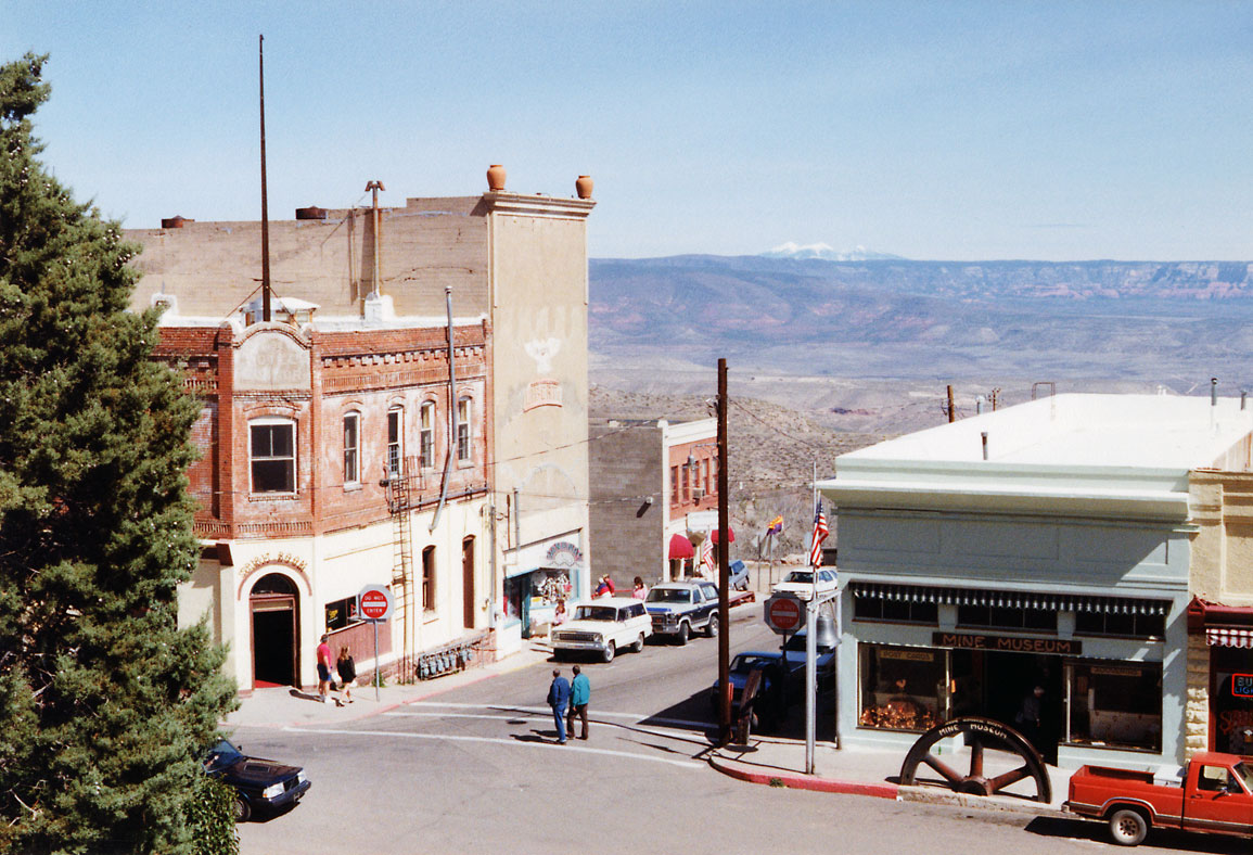
35°19′40″N 112°52′35″W / 35.327778°N 112.876389°WSeligman 14 Cottonwood Commercial Historic District May 18, 2000 Approximately from 712 to 1124 N. Main St.
34°44′52″N 112°01′36″W / 34.747778°N 112.026667°WCottonwood 15 Cross Creek Ranch House May 29, 2008 10 Russet Ridge Pl.
34°48′53″N 111°50′14″W / 34.814614°N 111.837173°WSedona 16 Crown King Ranger Station June 10, 1993 West of Crown King in the Prescott National Forest
34°12′22″N 112°20′27″W / 34.206111°N 112.340833°WCrown King 17 Edens House September 19, 1986 1015 N. Cactus St.
34°44′54″N 112°01′38″W / 34.748333°N 112.027222°WCottonwood 18 Fewke's Fort Below Aztec Pass (AR-03-09-06-23) January 20, 1989 Address Restricted Paulden Prescott Culture archaeological site 19 Fort Verde District 
October 7, 1971 Bounded by Hance, Coppinger, and Woods Sts.; also roughly north and east of Hance and Coppinger Sts. to Verde Ditch
34°33′54″N 111°51′08″W / 34.565°N 111.852222°WCamp Verde Fort Verde State Historic Park and vicinity. Second set of addresses represents a boundary increase. 20 Fossil Creek Bridge September 30, 1988 Forest Service Rd. over Fossil Creek
34°23′39″N 111°37′45″W / 34.394167°N 111.629167°WCamp Verde 21 Hatalacva Ruin July 24, 1974 Address Restricted Clarkdale Sinagua ruin 22 Hell Canyon Bridge September 30, 1988 Abandoned U.S. Route 89 over Hell Canyon
34°58′45″N 112°22′54″W / 34.979167°N 112.381667°WDrake 23 Hyde Mountain Lookout House January 28, 1988 Prescott National Forest
34°50′15″N 112°55′10″W / 34.8375°N 112.919444°WCamp Wood 24 Jerome Historic District 
November 13, 1966 Jerome
34°45′16″N 112°06′45″W / 34.754444°N 112.1125°WJerome 25 Kay-El-Bar Ranch May 22, 1978 North of Wickenburg on Rincon Rd.
34°00′34″N 112°44′53″W / 34.009444°N 112.748056°WWickenburg Guest ranch 26 Kirkland Store October 1, 1998 Main St. at the corner of Iron Springs Rd. and Kirkland Junction Rd.
34°25′01″N 112°42′32″W / 34.416944°N 112.708889°WKirkland 27 Little Hell Canyon Bridge September 30, 1988 Abandoned U.S. Route 89 over Little Hell Canyon
35°04′48″N 112°24′22″W / 35.08°N 112.406111°WDrake 28 Loy Butte Pueblo February 10, 1975 Address Restricted Sedona Sinagua ruin 29 Master Mechanic's House September 19, 1986 333 S. Willard St.
34°44′00″N 112°01′33″W / 34.733333°N 112.025833°WCottonwood 30 Mayer Apartments July 13, 1989 Central Ave., southwest of Ash St.
34°23′54″N 112°14′01″W / 34.398333°N 112.233611°WMayer 31 Mayer Business Block July 13, 1989 Oak St. and Central Ave.
34°23′54″N 112°13′57″W / 34.398333°N 112.2325°WMayer 32 Mayer Red Brick Schoolhouse July 21, 2004 Main St.
34°24′N 112°14′W / 34.4°N 112.24°WMayer 33 Mingus Lookout Complex January 28, 1988 Prescott National Forest
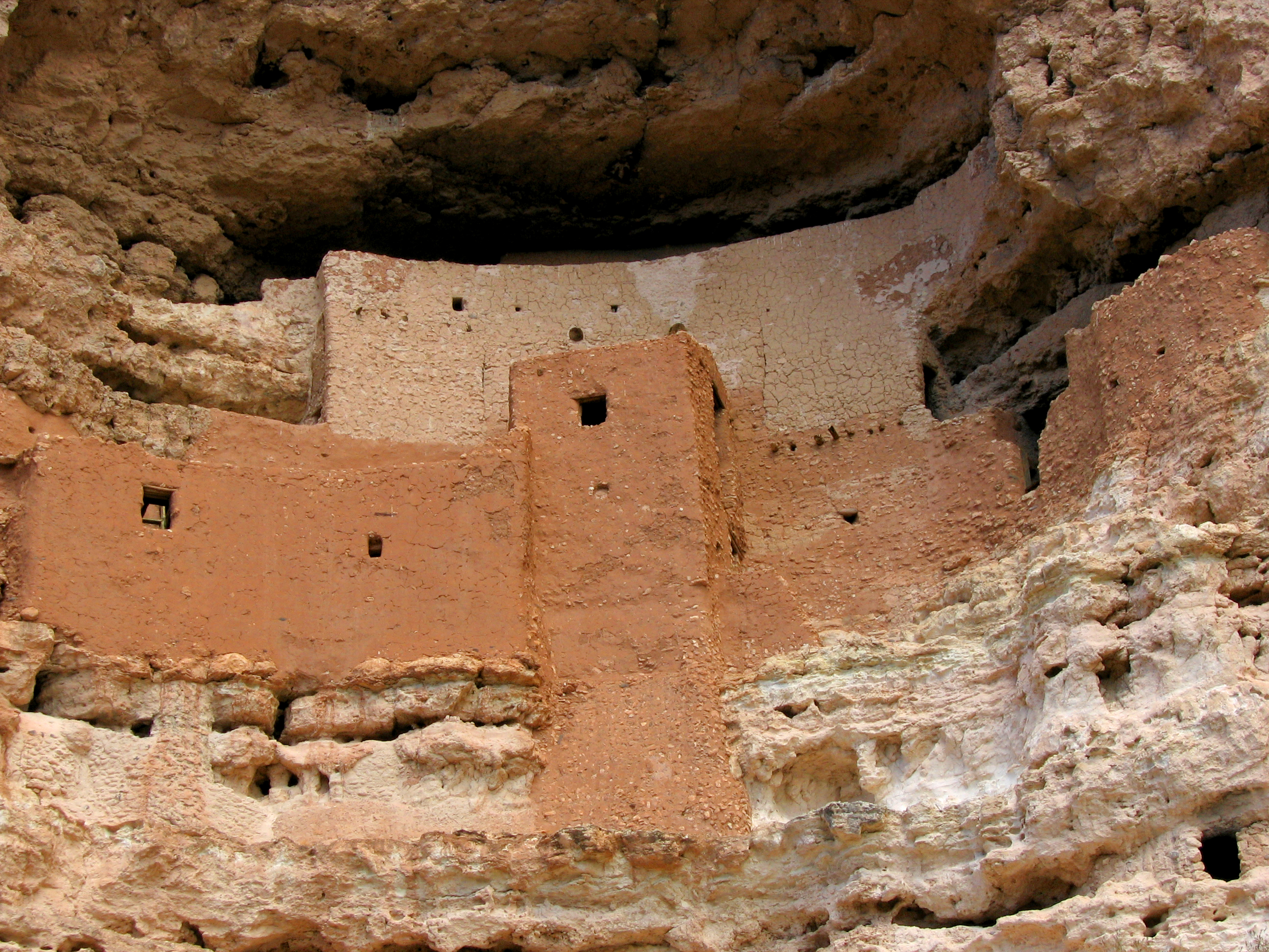
34°41′39″N 112°07′38″W / 34.694167°N 112.127222°WJerome 34 Montezuma Castle National Monument 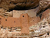
October 15, 1966 40 mi (64 km) south of Flagstaff on Interstate 17
34°38′19″N 111°47′17″W / 34.638611°N 111.788056°WCamp Verde Major Sinagua cliff dwelling 35 Pecan Lane Rural Historic Landscape May 11, 2000 537 to 867 Montezuma Castle Highway
34°34′47″N 111°51′12″W / 34.579722°N 111.853333°WCamp Verde 36 Peeples Valley School September 26, 2007 18205 U.S. Route 89
34°17′03″N 112°43′17″W / 34.284167°N 112.721389°WPeeples Valley 37 Perkinsville Bridge 
March 31, 1989 Perkinsville-Williams Rd. over the Verde River
34°53′43″N 112°12′18″W / 34.895278°N 112.205°WPerkinsville South of Ash Fork 38 Perry Mesa Archeological District November 20, 1975 Address Restricted Black Canyon City Located on Agua Fria National Monument 39 Poland Tunnel March 29, 1978 West of Poland off State Route 69
34°26′48″N 112°22′23″W / 34.446667°N 112.373056°WPoland 40 Rock House December 19, 1994 Pine Tree Ln. northwest of Groom Creek
34°29′21″N 112°26′45″W / 34.489167°N 112.445833°WGroom Creek 41 Sacred Mountain March 4, 1975 Address Restricted Rimrock Sinagua archaeological site 42 Santa Fe, Prescott & Phoenix Railway, Limestone Canyon District December 13, 1994 Address Restricted Ash Fork and Chino Valley 43 Seligman Commercial Historic District 
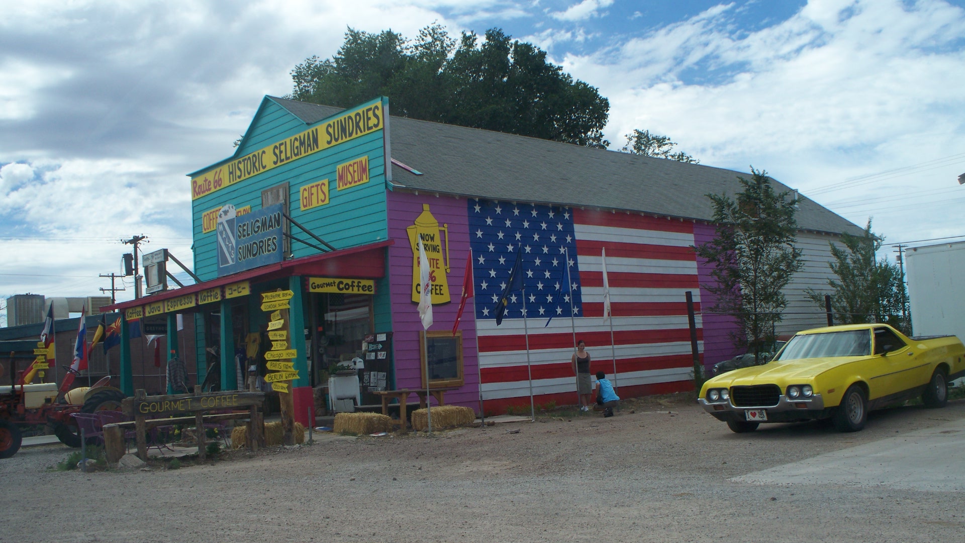
February 1, 2005 Roughly bounded by 1st and Lamport Sts. and Picacho and Railroad Aves.
35°19′35″N 112°52′27″W / 35.326389°N 112.874167°WSeligman 44 Smelter Machine Shop September 19, 1986 360 S. 6th St.
34°43′59″N 112°01′23″W / 34.733056°N 112.023056°WCottonwood 45 Strahan House September 19, 1986 725 E. Main St.
34°44′37″N 112°01′16″W / 34.743611°N 112.021111°WCottonwood 46 Superintendent's Residence October 14, 1986 315 S. Willard
34°44′01″N 112°01′33″W / 34.733611°N 112.025833°WCottonwood UVX smelter 47 Sycamore Cliff Dwelling September 28, 1990 Address Restricted Sedona Sinagua ruins 48 Sycamore Ranger Station June 10, 1993 Forest Rd. 68F southwest of Camp Verde in the Prescott National Forest
34°21′07″N 111°58′08″W / 34.351944°N 111.968889°WCamp Verde 49 Thompson Ranch September 19, 1986 2874 Alternate U.S. Route 89
34°43′17″N 111°59′32″W / 34.721389°N 111.992222°WCottonwood 50 Tuzigoot Museum September 9, 2010 Alternate US 89A and Tuzigoot Rd.
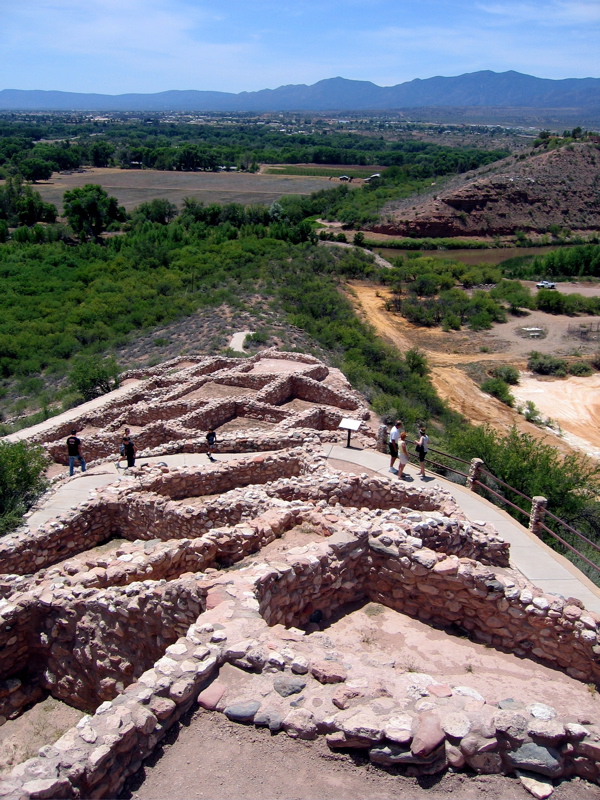
34°46′13″N 112°01′36″W / 34.770278°N 112.026667°WClarkdale 51 Tuzigoot National Monument Archeological District 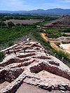
October 15, 1966 Address Restricted Clarkdale Large Sinagua pueblo 52 UVX Smelter Operations Complex September 19, 1986 361 S. Willard
34°43′57″N 112°01′34″W / 34.7325°N 112.026111°WCottonwood 53 Verde River Bridge September 30, 1988 2.7 mi (4.3 km) south of Paulden on Sullivan Lake Rd.
34°51′50″N 112°27′34″W / 34.863889°N 112.459444°WPaulden 54 Verde River Sheep Bridge 
November 21, 1978 North of Carefree on the Verde River
34°04′39″N 111°42′26″W / 34.0775°N 111.707222°WCarefree Demolished 1988 [1] 55 Walnut Creek Bridge March 31, 1989 Forest Service Rd. over Walnut Creek
34°55′44″N 112°48′55″W / 34.928889°N 112.815278°WSimmons 56 Walnut Grove Bridge September 30, 1988 3.5 mi (5.6 km) northwest of Walnut Grove on Wagoner Rd.
34°18′37″N 112°34′05″W / 34.310278°N 112.568056°WWalnut Grove 57 Willard House September 19, 1986 114 W. Main
34°45′01″N 112°01′43″W / 34.750278°N 112.028611°WCottonwood 58 Hank and Myrtle Wingfield Homestead July 27, 1999 806 E. Quarterhorse Ln.
34°32′07″N 111°50′27″W / 34.535278°N 111.840833°WCamp Verde 59 Robert W. Wingfield House February 3, 1986 Montezuma Castle Highway
34°34′55″N 111°51′09″W / 34.581944°N 111.8525°WCamp Verde 60 Woolsey Ranchhouse Ruins November 7, 1977 North of Humboldt off State Route 69
34°30′43″N 112°13′52″W / 34.511944°N 112.231111°WHumboldt King Woolsey's ranch, circa 1870 See also
- List of National Historic Landmarks in Arizona
- National Register of Historic Places listings in Arizona
References
- ^ The latitude and longitude information provided in this table was derived originally from the National Register Information System, which has been found to be fairly accurate for about 99% of listings. For about 1% of NRIS original coordinates, experience has shown that one or both coordinates are typos or otherwise extremely far off; some corrections may have been made. A more subtle problem causes many locations to be off by up to 150 yards, depending on location in the country: most NRIS coordinates were derived from tracing out latitude and longitudes off of USGS topographical quadrant maps created under the North American Datum of 1927, which differs from the current, highly accurate WGS84 GPS system used by Google maps. Chicago is about right, but NRIS longitudes in Washington are higher by about 4.5 seconds, and are lower by about 2.0 seconds in Maine. Latitudes differ by about 1.0 second in Florida. Some locations in this table may have been corrected to current GPS standards.
- ^ "National Register of Historic Places: Weekly List Actions". National Park Service, United States Department of the Interior. Retrieved on November 10, 2011.
- ^ Numbers represent an ordering by significant words. Various colorings, defined here, differentiate National Historic Landmark sites and National Register of Historic Places Districts from other NRHP buildings, structures, sites or objects.
U.S. National Register of Historic Places Topics Lists by states Alabama • Alaska • Arizona • Arkansas • California • Colorado • Connecticut • Delaware • Florida • Georgia • Hawaii • Idaho • Illinois • Indiana • Iowa • Kansas • Kentucky • Louisiana • Maine • Maryland • Massachusetts • Michigan • Minnesota • Mississippi • Missouri • Montana • Nebraska • Nevada • New Hampshire • New Jersey • New Mexico • New York • North Carolina • North Dakota • Ohio • Oklahoma • Oregon • Pennsylvania • Rhode Island • South Carolina • South Dakota • Tennessee • Texas • Utah • Vermont • Virginia • Washington • West Virginia • Wisconsin • WyomingLists by territories Lists by associated states Other Properties on the National Register of Historic Places in Arizona 
Municipalities and communities of Yavapai County, Arizona Cities Cottonwood | Peoria‡ | Prescott | Sedona‡

Towns CDPs Ash Fork | Bagdad | Big Park | Black Canyon City | Congress | Cordes Lakes | Cornville | Lake Montezuma | Mayer | Paulden | Peeples Valley | Seligman | Spring Valley | Verde Village | Wilhoit | Williamson | Yarnell
Unincorporated
communitiesCherry | Cleator | Crown King | Drake | Iron Springs | Kirkland | Red Rock | Skull Valley
Indian reservation Hualapai Indian Reservation
Ghost towns Alexandra | Big Bug | Bradshaw City | Bumble Bee | Catoctin | Cordes | Jerome Junction | Octave | Piedmont | Stanton | Tip Top | Weaver
Footnotes ‡This populated place also has portions in an adjacent county or counties
Categories:- National Register of Historic Places in Arizona by county
- Yavapai County, Arizona
- History of Yavapai County, Arizona
-


Wikimedia Foundation. 2010.