- National Register of Historic Places listings in Pinal County, Arizona
-
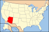
 Location of Pinal County in Arizona
This is a list of the National Register of Historic Places listings in Pinal County, Arizona.
This is intended to be a complete list of the properties and districts on the National Register of Historic Places in Pinal County, Arizona, United States. The locations of National Register properties and districts for which the latitude and longitude coordinates are included below, may be seen in a Google map.[1]
There are 109 properties and districts listed on the National Register in the county, including 1 that is also a National Historic Landmark.
-
- This National Park Service list is complete through NPS recent listings posted November 10, 2011.[2]
Current listings
[3] Landmark name Image Date listed Location City or town Summary 1 Acadia Ranch February 22, 1984 State Route 77
32°36′32″N 110°45′48″W / 32.608889°N 110.763333°WOracle Now the Acadia Ranch Museum 2 Adamsville Ruin August 25, 1970 Address Restricted Florence 3 All Saint's Church May 3, 1984 State Route 77
32°36′33″N 110°45′55″W / 32.609167°N 110.765278°WOracle 4 American Flag Post Office Ranch June 20, 1979 5 miles southeast of Oracle
32°35′N 110°43′W / 32.58°N 110.72°WOracle Oldest surviving territorial post office building in Arizona. 5 Ramon Arballo House August 1, 1986 405 Park St.
33°02′08″N 111°22′56″W / 33.035556°N 111.382222°WFlorence 6 Encarnacion Avenenti House July 13, 1987 203 Butte St.
33°01′52″N 111°23′07″W / 33.031111°N 111.385278°WFlorence 7 Earl Bayless House April 16, 1985 211 N. Cameron
32°52′42″N 111°44′50″W / 32.878333°N 111.747222°WCasa Grande 8 Wilbur O. Baylis/Grasty House April 16, 1985 221 N. Cameron
32°52′41″N 111°44′50″W / 32.878056°N 111.747222°WCasa Grande 9 Bien/McNatt House April 16, 1985 208A W. 1st St.
32°52′39″N 111°45′13″W / 32.8775°N 111.753611°WCasa Grande 10 Dr. George M. and Esther A. Brockway House May 26, 2004 501 S. Central Ave.
33°01′43″N 111°23′25″W / 33.028611°N 111.390278°WFlorence 11 Building at 121 North Florence Street November 20, 2002 121 N. Florence St.
32°52′35″N 111°45′14″W / 32.876389°N 111.753889°WCasa Grande 12 Building at 400 East Third Street November 20, 2002 400 E. 3rd St.
32°52′35″N 111°44′58″W / 32.876389°N 111.749444°WCasa Grande 13 Butte-Cochran Charcoal Ovens May 30, 1975 16 miles east of Florence north of Gila River
33°06′16″N 111°09′52″W / 33.104444°N 111.164444°WFlorence 14 C.H. Cook Memorial Church August 28, 1975 Church St.
33°04′44″N 111°44′28″W / 33.078889°N 111.741111°WSacaton 15 Camp Grant Massacre Site March 6, 1998 Address Restricted Lookout Mountain 16 Carminatti-Perham House August 1, 1986 6th and Florence Sts.
33°02′08″N 111°22′58″W / 33.035556°N 111.382778°WFlorence 17 Casa Grande Dispatch November 20, 2002 109 E. 2nd St.
32°52′36″N 111°45′10″W / 32.876667°N 111.752778°WCasa Grande 18 Casa Grande Hospital November 20, 2002 601 N. Cameron Ave.
32°52′44″N 111°44′50″W / 32.878889°N 111.747222°WCasa Grande 19 Casa Grande Hotel April 16, 1985 201 W. Main Ave.
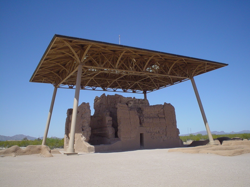
32°52′33″N 111°45′21″W / 32.875833°N 111.755833°WCasa Grande 20 Casa Grande National Monument 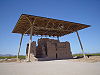
October 15, 1966 Casa Grande National Monument
32°59′49″N 111°31′55″W / 32.99694°N 111.53194°WCoolidge 21 Casa Grande Stone Church June 15, 1978 Florence Boulevard and N. Park Ave.
32°52′47″N 111°45′13″W / 32.879722°N 111.753611°WCasa Grande 22 Casa Grande Union High School and Gymnasium February 3, 1986 420 E. Florence Boulevard
32°52′49″N 111°44′49″W / 32.880278°N 111.746944°WCasa Grande 23 Casa Grande Woman's Club Building March 21, 1979 407 N. Sacaton St.
32°52′46″N 111°45′15″W / 32.879444°N 111.754167°WCasa Grande 24 Central Creditors Association Building April 16, 1985 118 N. Sacaton
32°52′38″N 111°45′19″W / 32.877222°N 111.755278°WCasa Grande 25 Church of the Nazarene November 20, 2002 305 E. 4th St.
32°52′39″N 111°45′00″W / 32.8775°N 111.75°WCasa Grande 26 H.H. Albert and Freeman Colton House August 1, 1986 1500 Willow St.
33°01′28″N 111°23′20″W / 33.024444°N 111.388889°WFlorence 27 Coolidge Dam 
October 29, 1981 Southwest of San Carlos
33°10′26″N 110°31′37″W / 33.173889°N 110.526944°WSan Carlos (ed. note: does this span 2 counties, should appear in other county list too) 28 Coolidge Woman's Club October 4, 1990 240 W. Pinkley Ave.
32°58′44″N 111°31′06″W / 32.978889°N 111.518333°WCoolidge 29 William Cox Building September 3, 1999 501 N. Marshall St.
32°52′42″N 111°45′03″W / 32.878333°N 111.750833°WCasa Grande 30 Cruz Trading Post April 16, 1985 200 W. Main St.
32°52′36″N 111°45′18″W / 32.876667°N 111.755°WCasa Grande 31 Judge William T. Day House July 25, 1985 310 W. 1st St.
32°52′41″N 111°45′20″W / 32.878056°N 111.755556°WCasa Grande 32 Devil's Canyon Bridge September 30, 1988 Abandoned U.S. Route 60 over Devil's Canyon
33°19′39″N 111°01′54″W / 33.3275°N 111.031667°WSuperior 33 James S. Melquides E. Douglass House May 27, 2004 850 S. Park St.
33°01′27″N 111°22′57″W / 33.024167°N 111.3825°WFlorence 34 Evergreen Addition Historic District January 22, 2009 Generally bounded by McMurray Blvd., Gilbert Ave., Florence Blvd., and Casa Grande Ave.
32°52′59″N 111°44′43″W / 32.883125°N 111.745369°WCasa Grande 35 First Baptist Church November 20, 2002 218 E. 8th St.
32°52′51″N 111°45′02″W / 32.880833°N 111.750556°WCasa Grande 36 First Florence Courthouse July 30, 1974 5th and Main Sts.
33°02′32″N 111°23′40″W / 33.042222°N 111.394444°WFlorence 37 First Presbyterian Church of Florence June 10, 1994 225 E. Butte Ave.
33°01′51″N 111°23′04″W / 33.030833°N 111.384444°WFlorence 38 Fisher Memorial Home April 16, 1985 300 E. 8th St.
32°52′50″N 111°45′02″W / 32.880556°N 111.750556°WCasa Grande 39 Florence Townsite Historic District October 26, 1982 Roughly bounded by 3rd and Florence Sts., Butte and Central Aves., and Chase/Ruggles Ditch
33°02′01″N 111°23′13″W / 33.033611°N 111.386944°WFlorence 40 Florence Union High School June 22, 1987 S. Main St.
33°01′21″N 111°23′16″W / 33.0225°N 111.387778°WFlorence 41 Thomas Fulbright House October 4, 1996 75 S. Matilda St.
33°01′50″N 111°23′00″W / 33.030556°N 111.383333°WFlorence 42 Grewe Site May 30, 2001 Address Restricted Coolidge 43 Ha-ak Va-ak Intaglio Site September 6, 1979 Address Restricted Sacaton 44 Harvey-Niemeyer House August 1, 1986 1613 Main St.
33°01′45″N 111°23′13″W / 33.029167°N 111.386944°WFlorence 45 C. D. Henry House August 1, 1986 1520 Willow St.
33°01′49″N 111°23′20″W / 33.030278°N 111.388889°WFlorence 46 Hieroglyphic Canyon Site April 11, 1994 Address Restricted Apache Junction 47 Hohokam-Pima National Monument July 19, 1974 20 miles south of Phoenix on Interstate 10
33°11′12″N 111°55′0″W / 33.18667°N 111.916667°WGila River Indian Reservation 48 House at 222 West Ninth St. November 20, 2002 222 W. 9th St.
32°52′54″N 111°45′19″W / 32.881667°N 111.755278°WCasa Grande 49 House at 317 East Eighth Street November 20, 2002 317 E. 8th St.
32°52′49″N 111°44′57″W / 32.880278°N 111.749167°WCasa Grande 50 House at 320 West Eighth Street November 20, 2002 320 W. 8th St.
32°52′50″N 111°45′24″W / 32.880556°N 111.756667°WCasa Grande 51 House at 323 West Eighth St. November 20, 2002 323 W. 8th St.
32°52′49″N 111°45′24″W / 32.880278°N 111.756667°WCasa Grande 52 House at 59 North Brown Avenue November 20, 2002 59 N. Brown Ave.
32°52′21″N 111°44′42″W / 32.87245°N 111.74502°WCasa Grande 53 House at 736 North Center Avenue November 20, 2002 736 N. Center Ave.
32°52′48″N 111°45′09″W / 32.88°N 111.7525°WCasa Grande 54 House at North Lehmberg Avenue November 20, 2002 1105 N. Lehmberg Ave.
32°53′08″N 111°44′34″W / 32.885556°N 111.742778°WCasa Grande 55 Dr. George Huffman House August 1, 1986 507 E. Butte St.
33°01′51″N 111°22′55″W / 33.030833°N 111.381944°WFlorence 56 Johnson's Grocery Store April 16, 1985 301 N. Picacho
32°52′36″N 111°45′02″W / 32.876667°N 111.750556°WCasa Grande 57 Kannally Ranch March 28, 1996 Mt. Lemmon Highway east of Oracle
32°36′34″N 110°43′59″W / 32.609444°N 110.733056°WOracle 58 Kelvin Bridge September 30, 1988 Florence-Kelvin Highway over the Gila River
33°06′10″N 110°58′26″W / 33.102778°N 110.973889°WKelvin 59 V.W. Kilcrease Building November 20, 2002 139 W. 1st St.
32°52′36″N 111°45′16″W / 32.876667°N 111.754444°WCasa Grande 60 Henry and Anna Kochsmeier House November 20, 2002 403 W. 2nd Ave.
32°52′33″N 111°45′32″W / 32.875833°N 111.758889°WCasa Grande 61 Gus Kratzka House April 16, 1985 N. Maricopa and 3rd St.
32°52′45″N 111°45′18″W / 32.879167°N 111.755°WCasa Grande 62 La Casa del High Jinks October 16, 1996 High Jinks Rd., 8 miles southeast of Oracle and 2.5 miles west of Mt. Lemmon Rd.
32°34′16″N 110°44′18″W / 32.571111°N 110.738333°WOracle 63 Laundry Building April 16, 1985 Rear of 309 W. 8th
32°52′49″N 111°45′22″W / 32.880278°N 111.756111°WCasa Grande 64 Dr. H. B. Lehmberg House April 16, 1985 929 N. Lehmberg
32°52′59″N 111°44′35″W / 32.883056°N 111.743056°WCasa Grande 65 Lincoln Hospital November 20, 2002 112 N. Brown Ave.
32°52′27″N 111°44′39″W / 32.874167°N 111.744167°WCasa Grande 66 Inez and Davis Littlefield Bea House August 1, 1986 1913 Elizabeth St.
33°01′38″N 111°23′08″W / 33.027222°N 111.385556°WFlorence 67 Andronico Lorona Second House August 1, 1986 704 Silver St.
33°02′05″N 111°22′51″W / 33.034722°N 111.380833°WFlorence 68 Los Robles Archeological District May 11, 1989 Address Restricted Red Rock 69 Magma Hotel August 19, 1994 100-130 Main St.
33°17′38″N 111°05′45″W / 33.293889°N 111.095833°WSuperior 70 Mandell and Meyer Building November 20, 2002 211 N. Florence St.
32°52′36″N 111°45′12″W / 32.876667°N 111.753333°WCasa Grande 71 Manjarres House August 6, 1987 203 Silver St.
33°02′05″N 111°22′49″W / 33.034722°N 111.380278°WFlorence 72 McClellan Wash Archeological District May 11, 1989 Address Restricted Picacho 73 James and Mary McGee House May 27, 2004 330 E. Butte Ave.
33°01′54″N 111°22′58″W / 33.031667°N 111.382778°WFlorence 74 Meehan/Gaar House April 16, 1985 202 W. 1st St.
32°52′37″N 111°45′15″W / 32.876944°N 111.754167°WCasa Grande 75 Mineral Creek Bridge September 30, 1988 Old U.S. Route 77 over Mineral Creek
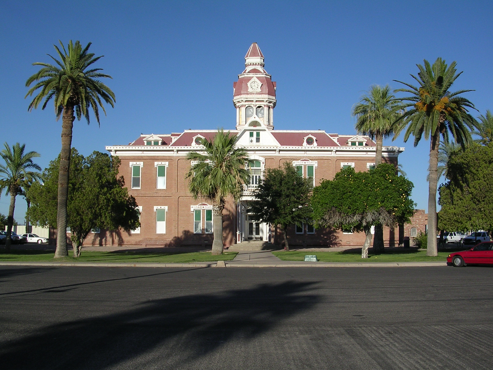
33°07′20″N 110°58′32″W / 33.122222°N 110.975556°WKelvin 76 Paramount Theatre September 3, 1999 420 N. Florence St.
32°52′42″N 111°45′07″W / 32.878333°N 111.751944°WCasa Grande 77 Period Revival House July 25, 1985 905 N. Lehmberg
32°52′57″N 111°44′35″W / 32.8825°N 111.743056°WCasa Grande 78 Picacho Pass Skirmish Site-Overland Mail Co. Stage Station at Picacho Pass November 22, 2002 1 mile northwest of Interchange #219 on Interstate 10
32°40′10″N 111°24′53″W / 32.669444°N 111.414722°WPicacho The site is near Picacho Peak State Park where a reenactment takes place. 79 Adrian Pierson House July 13, 1987 E. 6th St. and U.S. Route 89
33°02′08″N 111°22′42″W / 33.035556°N 111.378333°WFlorence 80 Pinal County Courthouse 
August 2, 1978 Pinal and 12th Sts.
33°01′56″N 111°23′06″W / 33.032222°N 111.385°WFlorence 81 Pioneer Market April 16, 1985 119 Florence St.
32°52′35″N 111°45′15″W / 32.876389°N 111.754167°WCasa Grande 82 Prettyman's Meat Market and Grocery/Brigg's Jeweler April 16, 1985 114 W. Main St.
32°52′34″N 111°45′16″W / 32.876111°N 111.754444°WCasa Grande 83 W. Y. Price House August 1, 1986 1612 Willow St.
33°01′48″N 111°23′20″W / 33.03°N 111.388889°WFlorence 84 Queen Creek Bridge 
September 30, 1988 Abandoned U.S. Route 60 over Upper Queen Creek Canyon
33°17′47″N 111°05′19″W / 33.296389°N 111.088611°WSuperior 85 Queen Creek Bridge September 30, 1988 Old Florence Highway over Queen Creek
33°17′16″N 111°19′42″W / 33.287778°N 111.328333°WFlorence Junction 86 Rancho Linda Vista September 9, 1999 1955 W. Linda Vista Rd.
32°36′12″N 110°47′41″W / 32.603333°N 110.794722°WOracle 87 Rancho Solano September 7, 1995 34145 S. Golder Dam Rd.
32°34′01″N 110°50′52″W / 32.566944°N 110.847778°WCatalina 88 S.S. Blinky Jr. Building November 20, 2002 511 W. 2nd St.
32°52′47″N 111°45′31″W / 32.879722°N 111.758611°WCasa Grande 89 Sacaton Dam Bridge September 30, 1988 Gila River Indian Reservation Rd.
33°05′19″N 111°41′11″W / 33.088611°N 111.686389°WSacaton 90 Saint Anthony's Church and Rectory April 16, 1985 215 N. Picacho
32°52′32″N 111°45′07″W / 32.875556°N 111.751944°WCasa Grande 91 San Tan Canal Bridge September 30, 1988 Gila River Indian Reservation Rd.
33°05′30″N 111°41′11″W / 33.091667°N 111.686389°WSacaton 92 Shonessy Building/Don Chun Wo Store April 16, 1985 121 W. Main Ave.
32°52′32″N 111°45′19″W / 32.875556°N 111.755278°WCasa Grande 93 Shonessy House April 16, 1985 115 W. Main Ave.
32°52′31″N 111°45′19″W / 32.875278°N 111.755278°WCasa Grande 94 Snaketown 
October 15, 1966 Chandler vicinity Chandler 95 Southern Pacific Railroad Depot November 20, 2002 201 W. Main St.
32°52′34″N 111°45′19″W / 32.876111°N 111.755278°WCasa Grande Burned 7-2009, no longer standing 96 Stone Bungalow April 16, 1985 515 E. 3rd St.
32°52′32″N 111°44′56″W / 32.875556°N 111.748889°WCasa Grande 97 Stone Warehouse April 16, 1985 119 Florence St. in rear
32°52′36″N 111°45′16″W / 32.876667°N 111.754444°WCasa Grande 98 Benjamin Templeton House November 20, 2002 923 N. Center Ave.
32°52′57″N 111°45′12″W / 32.8825°N 111.753333°WCasa Grande 99 Boyce Thompson Southwestern Arboretum March 26, 1976 2 miles west of Superior on U.S. Route 60
33°16′21″N 111°09′27″W / 33.2725°N 111.1575°WSuperior 100 Truman-Randall House July 13, 1987 2010 S. Main St.
33°01′37″N 111°23′14″W / 33.026944°N 111.387222°WFlorence 101 Valley National Bank November 20, 2002 221 N. Florence St.
32°52′14″N 111°45′12″W / 32.870556°N 111.753333°WCasa Grande 102 Vasquez House April 16, 1985 114 E. Florence Boulevard
32°52′48″N 111°45′08″W / 32.88°N 111.752222°WCasa Grande 103 Verdugo Homestead Historic District August 30, 2001 Address Restricted Randolph 104 Ward's Variety Store April 16, 1985 112 N. Sacaton
32°52′37″N 111°45′19″W / 32.876944°N 111.755278°WCasa Grande 105 P. C. Warner First House August 1, 1986 310 3rd St.
33°02′13″N 111°23′05″W / 33.036944°N 111.384722°WFlorence 106 White House April 16, 1985 901 N. Morrison
32°52′54″N 111°44′47″W / 32.881667°N 111.746389°WCasa Grande 107 Walter Wilbur House November 20, 2002 904 E. 8th St.
32°52′50″N 111°44′32″W / 32.880556°N 111.742222°WCasa Grande 108 C. J. (Blinky) Wilson House April 16, 1985 223 W. 10th
32°52′57″N 111°45′18″W / 32.8825°N 111.755°WCasa Grande 109 Winkelman Bridge September 30, 1988 Old State Route 77 over the Gila River
32°59′06″N 110°46′18″W / 32.985°N 110.771667°WWinkelman See also
- List of National Historic Landmarks in Arizona
- National Register of Historic Places listings in Arizona
References
- ^ The latitude and longitude information provided in this table was derived originally from the National Register Information System, which has been found to be fairly accurate for about 99% of listings. For about 1% of NRIS original coordinates, experience has shown that one or both coordinates are typos or otherwise extremely far off; some corrections may have been made. A more subtle problem causes many locations to be off by up to 150 yards, depending on location in the country: most NRIS coordinates were derived from tracing out latitude and longitudes off of USGS topographical quadrant maps created under the North American Datum of 1927, which differs from the current, highly accurate WGS84 GPS system used by Google maps. Chicago is about right, but NRIS longitudes in Washington are higher by about 4.5 seconds, and are lower by about 2.0 seconds in Maine. Latitudes differ by about 1.0 second in Florida. Some locations in this table may have been corrected to current GPS standards.
- ^ "National Register of Historic Places: Weekly List Actions". National Park Service, United States Department of the Interior. Retrieved on November 10, 2011.
- ^ Numbers represent an ordering by significant words. Various colorings, defined here, differentiate National Historic Landmark sites and National Register of Historic Places Districts from other NRHP buildings, structures, sites or objects.
U.S. National Register of Historic Places Topics Lists by states Alabama • Alaska • Arizona • Arkansas • California • Colorado • Connecticut • Delaware • Florida • Georgia • Hawaii • Idaho • Illinois • Indiana • Iowa • Kansas • Kentucky • Louisiana • Maine • Maryland • Massachusetts • Michigan • Minnesota • Mississippi • Missouri • Montana • Nebraska • Nevada • New Hampshire • New Jersey • New Mexico • New York • North Carolina • North Dakota • Ohio • Oklahoma • Oregon • Pennsylvania • Rhode Island • South Carolina • South Dakota • Tennessee • Texas • Utah • Vermont • Virginia • Washington • West Virginia • Wisconsin • WyomingLists by territories Lists by associated states Other Properties on the National Register of Historic Places in Arizona 
Municipalities and communities of Pinal County, Arizona Cities Apache Junction‡ | Casa Grande | Coolidge | Eloy | Maricopa

Towns CDPs Ak-Chin Village | Arizona City | Blackwater | Cactus Forest | Campo Bonito | Casa Blanca | Chuichu | Dudleyville | Gold Canyon | Goodyear Village | Kohatk | Oracle | Picacho | Queen Valley | Red Rock | Sacaton | Sacaton Flats Village | Saddlebrooke | San Manuel | Santa Cruz | Santan | San Tan Valley | Stanfield | Stotonic Village | Sweet Water Village | Tat Momoli | Top-of-the-World‡ |
Unincorporated
communitiesBapchule | Chandler Heights‡ | Randolph | Valley Farms
Indian reservations Ghost towns American Flag | Cochran | Copper Creek | Pinal City | Ray | Reymert | Sasco | Tiger
Footnotes ‡This populated place also has portions in an adjacent county or counties
Categories:- National Register of Historic Places in Arizona by county
- Pinal County, Arizona
- History of Pinal County, Arizona
-


Wikimedia Foundation. 2010.