- Coolidge Dam
-
Coolidge Dam 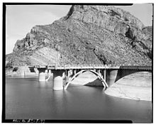
Upstream face of Coolidge Dam, from Historic American Engineering RecordCountry United States Location Gila County, Arizona Coordinates 33°10′29″N 110°31′40″W / 33.174687°N 110.527863°WCoordinates: 33°10′29″N 110°31′40″W / 33.174687°N 110.527863°W Status Operational Construction began 1924 Opening date 1930 Construction cost US$10 million Owner(s) San Carlos Indian Irrigation District Dam and spillways Type of dam Arch dam Height 249 ft Crest width 580 ft Volume 200,000 cuyd Crest elevation 2535 ft Impounds Gila River Spillways 2 Type of spillway Ogee Reservoir Creates San Carlos Reservoir Capacity 910,000 acre·ft (1.12×10⁹ m3) Type Conventional The Coolidge Dam is a reinforced concrete multiple dome and buttress dam 31 miles (50 km) southeast of Globe, Arizona on the Gila River. Built between 1924 and 1928, the Coolidge Dam was part of the San Carlos Irrigation Project. Coolidge Dam was named after the 30th US President, Calvin Coolidge and was dedicated by President Coolidge on March 4, 1930. The design and construction engineer was Herman Neuffer, who oversaw much of the construction undertaken by the Bureau during the 1920s in Arizona and New Mexico.
Coolidge Dam impounds San Carlos Lake in the San Carlos Apache Indian Reservation. The project irrigates 100,000 acres (400 km²).
Since the water is impounded so it can be released when farmers need it, San Carlos Lake is often at a low level except in wet periods. When former President Coolidge dedicated the dam in 1930, the dam had not begun to fill. Cherokee humorist Will Rogers looked at the grass in the lake bed, and said, “If this were my dam, I’d mow it.”[1]
Contents
History
Construction
Coolidge Dam was constructed by the Bureau of Indian Affairs (BIA), which also owns and operates it, at a cost of US$10 million.[2] It was built between 1924 and 1928. The overall structure used 200,000 cubic yards (150,000 m3) of concrete and consists of three domes, which are supported by massive buttresses on 100-foot (30 m) centers. It rises 249 feet (76 m), with a crest length of 580 feet (180 m). Two uncontrolled ogee crest spillways are concrete lined and located on each abutment.[3]
Opposition from Apache tribe
Construction of the dam incurred opposition from the Apache tribe, who feared a violation of their treaty rights, according to an author writing for the Federal Writers' Project:
- A compromise was finally made with the Indians, and the tribal burial grounds and the old camp from which Geronimo started his bloody raids now lie deep under the waters of the reservoir. It was proposed to disinter the bodies but the Apache vehemently objected to what they considered desecration of the dead, so a concrete slab was laid over the principal burial ground at a cost of $11,000.[4]
Hydroelectric power generation
As part of the San Carlos Indian Irrigation Project (SCIIP), Coolidge Dam generates electricity from a hydroelectric plant. A diesel electric generating plant also run by the Project was built simultaneously and located on reservation land near the town of Coolidge. Both facilities provide power for irrigation wells, local towns, rural users and mining operations.[5] The electric plant at the dam was completed and began generating electricity in 1935, and the diesel plant was completed in December of that year and produced electricity the following year.[6]
Structural modifications
In 1988, the Bureau of Reclamation completed a study that concluded that the dam needed modifications to prevent a failure should a significant flood or an earthquake occur. Earlier floods that had resulted in water topping the dam had eroded the abutments, and the buttresses were judged to be unstable. Work started in 1991 and included an access road to the downstream side of the dam. The work concluded in 1995. The final cost was estimated at $US46.5 million.[7]
Flood of 1993
In January of 1993, heavy rainfall (up to three times the normal amount) in Arizona filled San Carlos Lake and the operators were forced to release excess water. The ground was saturated, and the continuing rainfall ran off into the streams and rivers. In addition, the weather pattern for the year caused higher than normal temperatures in areas that would typically remain under snow. These areas received rain instead of snow, and the rivers began to run earlier and with far more volume than normal. Rivers in the southern part of Arizona at that time contained anywhere from three to nearly six times their normal amount of water. To complicate matters, the snowpack was already 150% the normal amount. Dam operators for Coolidge Dam released water in record levels because storage capacity had been reached.[8]
As a result of the heavy water releases, several El Paso Natural Gas pipelines, which crossed the Gila River near Coolidge, Winkleman, and Kelvin were “scoured” or uncovered by the force of the water and failed. The water flow was concentrated through the release gates, as opposed to letting the water overtop the dam, which would have created a different scour rate. The force of the Gila River undermined and ultimately caused the failure of the north and south abutments of the bridge crossing at Attaway Road, upstream from Coolidge. The estimated flow from Coolidge Dam during January of 1993 was 927 cubic meters per second, about seven times the expected maximum release rate, 133 cubic meters per second, and was the highest release rate for the dam since its construction. Discharge at Winkleman was recorded at 1050 cubic meters per second on January 20, 1993. Winkleman Flats, a small area near Winkleman, was flooded as well.[8] However, despite earlier concerns about the dam's safety, it survived the flood even though retrofit work was in process at the time.
Recreational use
 Gila River downstream from Coolidge Dam
Fishing and boating
San Carlos Lake is stocked periodically, and when the winter has experienced average or above average precipitation, is one of the largest lakes in Arizona. The San Carlos Apache Tribe Recreation & Wildlife Dept. stocks several species of fish using various methods to create a good fishing environment. Several species are self-sustaining:
- sunfish (Lepomis sp.)
- largemouth bass (Micropterus salmoides)
- black crappie (Pomoxis nigromaculatus)
- channel catfish (Ictalurus punctatus)
- flathead catfish (Pylodictis olivaris)
Other fish are stocked from cold-water fisheries including brown trout and rainbow trout. Jet-skiing, water skiing and boating are allowed. Individuals who are not members of the San Carlos Apache tribe who wish to use the lake must contact the tribal office for a permit since the lake is on tribal land.[9]
Bicycle trail
Bicyclists can ride the access road to the dam face and back. The route is scenic and little-traveled, and rises a total of about 700 feet along the 13 mile route. The elevation at the dam is about the same as the starting point, so the trip is not strictly a climb, but peaks about the middle of the distance and then descends again to about 2,600 ft.
When they reach the dam, cyclists can either return to the starting point along the two-lane paved road, or they can continue eastward along the rougher part of the road until it rejoins US Route 70. Before traveling on the reservation, non-tribe members must obtain a permit. A mountain bike or other rugged type bicycle is recommended for cyclists traveling east from the dam to Rte 70.[10]
References
- ^ Coolidge Dam Celebrates 78th Anniversary | Copper Country News
- ^ Unsigned (January 1929). "Huge Domes Strengthen New Coolidge Dam". Popular Science (Bonnier Corporation) 114 (1): 66. ISSN 0161-7370. http://books.google.com/books?id=oCcDAAAAMBAJ&pg=PA66#v=onepage&q&f=false. Retrieved 30 May 2011.
- ^ "Coolidge Dam". US Bureau of Reclamation. Archived from the original on 2001-10-31. http://web.archive.org/web/20011031185425/http://www.usbr.gov/cdams/dams/coolidge.html. Retrieved 2011-05-31.
- ^ Federal Writers' Project (1966). Arizona, The Grand Canyon State: A State Guide. US History Publishers. p. 14. ISBN 9781603540032. http://books.google.com/books?id=mB9Sm6JCnAQC.
- ^ Bennett, Elmer F. (2008). Federal Indian Law (Reprint ed.). The Lawbook Exchange, Ltd.. p. 302. ISBN 9781584777762. http://books.google.com/books?id=YOT45AKh9VMC&source=gbs_navlinks_s.
- ^ United States. Congress. House (1938). Hearings, Volume 10. the University of Michigan.. p. 240. ISBN 9781584777762. http://books.google.com/books?id=eTdDWw_PhmMC.
- ^ United States. Dept. of the Interior. Office of Inspector General; Robert J. Williams (1998) (digital). Audit report: safety of dams project constructed by the Bureau of Reclamation at Coolidge Dam. p. 3. http://azmemory.lib.az.us/cdm4/item_viewer.php?CISOROOT=/feddocs&CISOPTR=612&CISOBOX=1&REC=1. Retrieved 31 May 2011.
- ^ a b Slosson, James E.; Robert A. Larson (1997). Robert A. Larson. ed. Storm-induced geologic hazards: case histories from the 1992-1993 winter in southern California and Arizona (Illustrated ed.). Geological Society of America. p. 26. ISBN 9780813741116. http://books.google.com/books?id=4EpSB8I6ruQC&pg=PA34#v=onepage&q&f=false.
- ^ "Southwest Tribal Fisheries Commission". http://www.swtfc.org/tribal_profiles_and_map/san_carlos.htm. Retrieved 31 May 2011.
- ^ Maxa, Christine; David A. James (2007). Cycling Arizona: The Statewide Road Biking Guide (Illustrated ed.). Big Earth Publishing. pp. 158–159. ISBN 9781565795372.
External links
- USBR Coolidge Dam Website[dead link]
- Coolidge Dam photo series from Historic American Engineering Record
- Southwest Tribal Fisheries Commission - San Carlos Apache Tribe
- San Carlos Apache Tribe Recreation & Wildlife Dept. - hunting permission forms and information about fishing permits
- The American Southwest: San Carlos Lake
- http://web.archive.org/web/20011031185425/http://www.usbr.gov/cdams/dams/coolidge.html
U.S. National Register of Historic Places Topics Lists by states Alabama • Alaska • Arizona • Arkansas • California • Colorado • Connecticut • Delaware • Florida • Georgia • Hawaii • Idaho • Illinois • Indiana • Iowa • Kansas • Kentucky • Louisiana • Maine • Maryland • Massachusetts • Michigan • Minnesota • Mississippi • Missouri • Montana • Nebraska • Nevada • New Hampshire • New Jersey • New Mexico • New York • North Carolina • North Dakota • Ohio • Oklahoma • Oregon • Pennsylvania • Rhode Island • South Carolina • South Dakota • Tennessee • Texas • Utah • Vermont • Virginia • Washington • West Virginia • Wisconsin • WyomingLists by territories Lists by associated states Other  Category:National Register of Historic Places •
  Portal:National Register of Historic Places
Power stations in Arizona Coal-fired
generating stationsHydroelectric dams Wind farms Solar thermal plants Nuclear plants Utility companies Arizona Electric Power Cooperative • Arizona Public Service • Salt River Project • Tucson Electric PowerCategories:- Buildings and structures on the National Register of Historic Places in Arizona
- Buildings and structures in Gila County, Arizona
- Buildings and structures in Pinal County, Arizona
- Buttress dams
- Calvin Coolidge
- Dams in Arizona
- Dams on the National Register of Historic Places
- Gila River
- Hydroelectric power plants in Arizona
- Arizona building and structure stubs
- United States dam stubs


Wikimedia Foundation. 2010.