- Cholla Power Plant
-
Cholla Power Plant 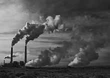 Location of Cholla Power Plant
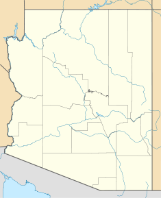

Country United States Location Joseph City, AZ Coordinates 34°56′25″N 110°18′01″W / 34.94028°N 110.30028°WCoordinates: 34°56′25″N 110°18′01″W / 34.94028°N 110.30028°W Status Active Commission date 1962 Owner(s) Arizona Public Service Power station information Primary fuel Subbituminous coal Power generation information Maximum capacity 1021 MW Cholla is a major coal-fired power plant near Joseph City, Arizona. The coal burned at the plant comes from the McKinley Mine in New Mexico.
Units
The plant currently consists of the following units:[1]
Unit Nameplate capacity (MWe) Commissioning Notes 1 113.6 1962 2 288.9 1978 3 312.3 1980 4 414 1981 References
- ^ "Existing Electric Generating Units in the United States, 2006" (Excel). Energy Information Administration, U.S. Department of Energy. 2006. http://www.eia.doe.gov/cneaf/electricity/page/capacity/capacity.html. Retrieved 2008-07-14.
External links
Power stations in Arizona Coal-fired
generating stationsAbitibi Snowflake • Apache • Cholla • Coronado • H. Wilson Sundt • NavajoHydroelectric dams Wind farms Solar thermal plants Nuclear plants Utility companies Arizona Electric Power Cooperative • Arizona Public Service • Salt River Project • Tucson Electric PowerCategories:- Buildings and structures in Navajo County, Arizona
- Coal-fired power stations in Arizona
- United States power station stubs


Wikimedia Foundation. 2010.