- National Register of Historic Places listings in La Paz County, Arizona
-
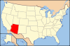
 Location of La Paz County in Arizona
This is a list of the National Register of Historic Places listings in La Paz County, Arizona. It is intended to be a complete list of the properties and districts on the National Register of Historic Places in La Paz County, Arizona, United States. The locations of National Register properties and districts for which the latitude and longitude coordinates are included below, may be seen in a Google map.[1]
There are 9 properties and districts listed on the National Register in the county.
-
- This National Park Service list is complete through NPS recent listings posted November 10, 2011.[2]
Listings county-wide
[3] Landmark name Image Date listed Location City or town Summary 1 Eagletail Petroglyph Site September 28, 1988 Address Restricted Hyder 2 Harquahala Mountain Smithsonian Solar Observatory Historic District May 1, 1997 Harquahala Mountain (Wilderness), southwest of Gladden Gladden 3 Harquahala Peak Observatory October 3, 1975 East of Wenden off U.S. Route 60
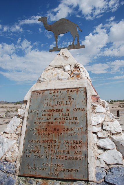
33°48′48″N 113°20′44″W / 33.813333°N 113.345556°WWenden 4 Hi Jolly Monument 
February 28, 2011 North end of Cemetery Rd.
33°39′52″N 114°14′11″W / 33.664444°N 114.236389°WQuartzsite Pyramidal Monuments in Arizona MPS 5 Rhoda Nohlechek House May 10, 1996 Northwestern corner of the junction of 2nd St. and Date Ave.
33°49′24″N 113°32′27″W / 33.823333°N 113.540833°WWenden 6 Old La Paz August 25, 1970 Address Restricted Ehrenberg 7 Old Presbyterian Church June 3, 1971 Southwest of Parker on 2nd Ave.
34°06′45″N 114°18′48″W / 34.1125°N 114.313333°WParker 8 Parker Jail April 3, 1975 Northern side of Agency Rd. in Pop Harvey Park
34°08′55″N 114°17′39″W / 34.148611°N 114.294167°WParker 9 Ripley Intaglios November 20, 1975 Address Restricted Ehrenberg See also
- List of National Historic Landmarks in Arizona
- National Register of Historic Places listings in Arizona
References
- ^ The latitude and longitude information provided in this table was derived originally from the National Register Information System, which has been found to be fairly accurate for about 99% of listings. For about 1% of NRIS original coordinates, experience has shown that one or both coordinates are typos or otherwise extremely far off; some corrections may have been made. A more subtle problem causes many locations to be off by up to 150 yards, depending on location in the country: most NRIS coordinates were derived from tracing out latitude and longitudes off of USGS topographical quadrant maps created under the North American Datum of 1927, which differs from the current, highly accurate WGS84 GPS system used by Google maps. Chicago is about right, but NRIS longitudes in Washington are higher by about 4.5 seconds, and are lower by about 2.0 seconds in Maine. Latitudes differ by about 1.0 second in Florida. Some locations in this table may have been corrected to current GPS standards.
- ^ "National Register of Historic Places: Weekly List Actions". National Park Service, United States Department of the Interior. Retrieved on November 10, 2011.
- ^ Numbers represent an ordering by significant words. Various colorings, defined here, differentiate National Historic Landmark sites and National Register of Historic Places Districts from other NRHP buildings, structures, sites or objects.
U.S. National Register of Historic Places Topics Lists by states Alabama • Alaska • Arizona • Arkansas • California • Colorado • Connecticut • Delaware • Florida • Georgia • Hawaii • Idaho • Illinois • Indiana • Iowa • Kansas • Kentucky • Louisiana • Maine • Maryland • Massachusetts • Michigan • Minnesota • Mississippi • Missouri • Montana • Nebraska • Nevada • New Hampshire • New Jersey • New Mexico • New York • North Carolina • North Dakota • Ohio • Oklahoma • Oregon • Pennsylvania • Rhode Island • South Carolina • South Dakota • Tennessee • Texas • Utah • Vermont • Virginia • Washington • West Virginia • Wisconsin • WyomingLists by territories Lists by associated states Other Properties on the National Register of Historic Places in Arizona 
Municipalities and communities of La Paz County, Arizona Towns 
CDPs Unincorporated
communityIndian reservations Ghost towns Categories:- National Register of Historic Places in Arizona by county
- La Paz County, Arizona
- History of La Paz County, Arizona
-


Wikimedia Foundation. 2010.