- U.S. Route 89A
Infobox U.S. Route
route=89A
alternate_name=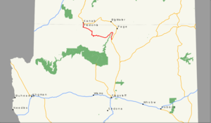
length_mi=91.74
length_round=0
length_ref= [Summing AZ and UT Milage logs used as sources in the Major intersections section]
established=1960
decommissioned=
direction_a=South
starting_terminus=
junction=
direction_b=North
ending_terminus=
cities=Fredonia, AZ
Kanab, UT
spur_type=US
spur_of=89U.S. Route 89A is a north-south auxiliary
U.S. highway , though its actual direction of travel is more east-west. The state of Arizona has designated this highway the Fredonia-Vermilion Cliffs Scenic Road. [cite web
url=http://www.azdot.gov/highways/SWProjMgmt/enhancement/scenic_roads/scenic_roads_byways.asp
title = Scenic Roads
publisher = Arizona Department of Transportation] The highway is used to accessGrand Canyon National Park and is known for theNavajo Bridge . Until 2008, the Utah portion was known as State Route 11.Route description
The highway's southern terminus is at U.S. Route 89 south of
Page, Arizona . Its northern terminus is inKanab, Utah , also as US-89. US 89A runs near or throughLee's Ferry , theNavajo Bridge ,Vermilion Cliffs , theKaibab Plateau , andFredonia, Arizona . The eastern portion of the highway runs through part of theNavajo Nation . FromJacob Lake , State Route 67 leads south to the North Rim ofGrand Canyon National Park . Then north to the neighboring cities ofFredonia, Arizona andKanab, Utah . The Utah portion of US 89A is defined by Utah Code Annotated §72-4-114.cite web
url=http://le.utah.gov/~code/TITLE72/htm/72_04_011400.htm
title = Utah Code
author = State of Utah
accessdate=2008-03-22]History
This was part of mainline U.S. 89 until the construction of
Glen Canyon Dam . In1960 , U.S. 89 was moved to a new, more northerly route and the old route became U.S. 89A.The Utah segment of U.S. 89A was first commissioned State Route 11 in 1910. This highway ran from Nephi to the
Arizona state line near Kanab. This route is still drivable as the modern US-89A, US-89, and SR-132. With the establishment of theUnited States highway system in 1926, most of SR-11 was used for the routing of US-89 through southern Utah; the official route designation, however, remained SR-11.cite web
url = http://www.dot.utah.gov/main/uconowner.gf?n=200609121819241
title = Highway Resolutions - Route 11
format = pdf
date =2007-09
accessdate =2008-02-03
publisher = Utah Department of Transportation] In 1969, as part of a series of changes to state routes, the portion north of Sevier Junction (I-70 and US-89 near Joseph) was transferred to other routes, leaving no part of SR-11 was signed with the number. It is also during this time that that a new alignment for US-89 was constructed to serve theGlen Canyon Dam , with SR-11 being now signed as US-89A south of Kanab and US-89 to the north. As part of the1977 Utah state route renumbering to conform signage and legislative definitions, SR-11 was truncated to what is now signed US89A. The route was signed SR-11, with "TO US-89A" at the northern terminus in Kanab and a "TO US-89" at the Arizona state line. In 2008, however, SR-11 was deleted after a bill in the Utah legislature was passed to restore U.S. Route 89A in Utah.cite web
url= http://le.utah.gov/~2008/htmdoc/hbillhtm/HB0061.htm
title = H.B. 61 Bill Documents - 2008 General Session
publisher = State of Utah|]Junction list
ee also
*
U.S. Route 89
*Arizona State Route 89A References
External links
* [http://www.arizonaroads.com/us/us89a.html US-89A at Arizona Roads]
* [http://members.aol.com/utahhwys/001-020.htm#rte011 State Route 11 at Utah Highways]
###@@@KEYEND@@@###

Wikimedia Foundation. 2010.