- Arizona State Route 89A
Infobox road
marker_
state=AZ
highway_name=
name_notes=
type=state
route=89A
alternate_name=
maint=ADOT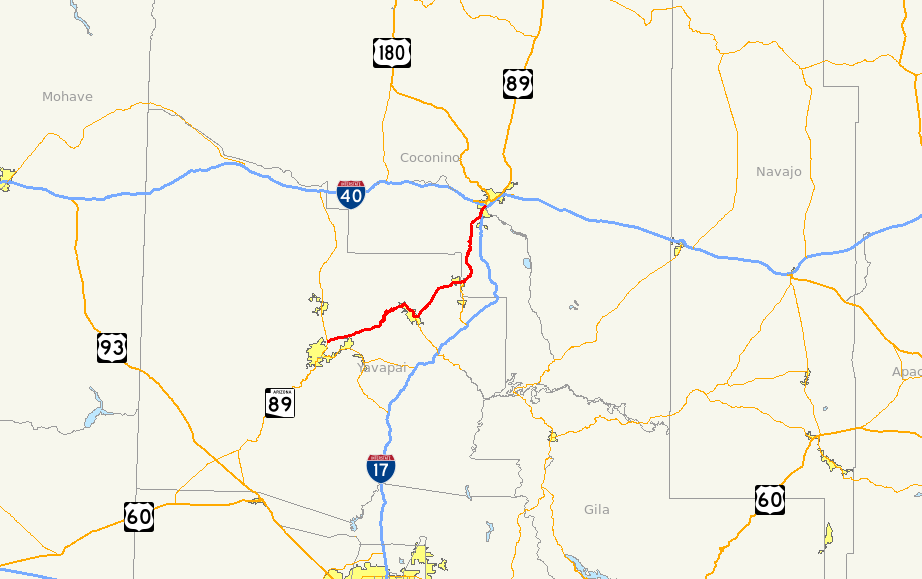
length_mi=79.85
length_round=2
length_ref=cite web|url=http://tpd.az.gov/data/reports/2006SHSLog.pdf|title=2006 ADOT Highway Log|publisher=Arizona Department of Transportation |accessdate=2008-04-08]
length_notes=
established=
decommissioned=
direction_a=South
starting_terminus=jct|state=AZ|SR|89 in Prescott
junction=jct|state=AZ|I|17 in Flagstaff
jct|state=AZ|I|40 in Flagstaff
direction_b=North
ending_terminus=jct|state=AZ|BL|40|dab1=Flagstaff in Flagstaff
previous_type=US
previous_route=89A
next_type=AZ
next_route=89L
commons=State Route 89A (SR 89A) is a convert|79.85|mi|km|sing=on
state highway that runs from Prescott north to Flagstaff in theU.S. state ofArizona . The highway is notable for its scenic value as it passes through Sedona and theOak Creek Canyon . SR 89A was initially established as a state highway in 1927 as SR 79. It later became U.S. Route 89A in 1941 before becoming SR 89A in 1992.Route description
SR 89A runs from its southern terminus in Prescott northward through the towns of Jerome, Cottonwood and Sedona to its northern terminus in Flagstaff. The highway is known for its scenic views as it passes through the Sedona and
Oak Creek Canyon .Prescott to Jerome
The southern terminus of SR 89A is located at a junction with SR 89 north of Prescott near the Antelope Hills Golf Course and
Ernest A. Love Field . The highway heads east from the junction with SR 89 as a four-lanedivided highway withdiamond interchange s located at some intersections. It continues as a divided highway until it reaches Fain Road in Prescott Valley. The highway continues beyond this intersection as a two-lane undivided highway.As the highway continues to the northeast, it begins to ascend the Black Hills mountain range. The highway follows the terrain through a series ofhairpin turn s as the it climbs in elevation. Once the highway reaches passes over the mountains, it begins its descent into theVerde Valley . During its descent, SR 89A enters the town of Jerome. In Jerome, the highway provides access to theJerome State Historical Park .Jerome to Sedona
SR 89A heads northeast as it leaves Jerome through the Verde Valley. After it enters the town of Clarkdale, it turns towards the southeast at an intersection with 11th Street. The highway provides access to the
Tuzigoot National Monument andDead Horse Ranch State Park along this stretch. It continues towards the southeast through Clarkdale before it enters the town of Cottonwood. In Cottonwood, the highway begins to follow Cottonwood Street until it reaches an intersection with Main Street. It turns towards the southeast to follow Main Street to an intersection with SR 260. SR 260 heads towards the south towards the city of Camp Verde while SR 89A heads towards the northeast towards Sedona.As the highway heads towards the northeast from Cottonwood, it becomes a divided highway north of Rocking Chair Road. Before reaching Sedona, SR 89A provides access to
Red Rock State Park . The highway remains a divided highway until it reaches Sedona. Sedona is an arts and resort community known for its redsandstone formations.cite book |title=Scenic Driving Arizona |last=Green |first=Stewart |year=2003 |publisher=Falcon |isbn=0-7627-2701-2 |edition=2nd Edition |page=107] As it enters Sedona, SR 89A is known as the Si Birch Memorial Highway. The highway continues east through Sedona, providing access to theSedona Airport . SR 89A continues towards the east through Sedona to an intersection with SR 179. SR 179 heads south from this intersection through the southern part of Sedona and also provides access toInterstate 17 .edona to Flagstaff
The highway heads northeast from Sedona and follows Oak Creek as it enters Oak Creek Canyon. SR 89A curves to the north as it follows the creek and provides access to
Slide Rock State Park along this portion of the highway. The highway leaves the creek as it begins to ascend the canyon. It goes through a series ofhairpin turn s to reach the top of the canyon on theMogollon Rim . There is a scenic view area off of the highway at the top of the canyon. SR 89A continues north away from the canyon towards Flagstaff. The highway curves towards the northeast as it passes to the west of the Forest Highlands Gold Club. The highway continues to the northeast to I-17 in Flagstaff nearFlagstaff Pulliam Airport . SR 89A begins to run concurrently with I-17 towards the north from this point. The two highways continue north to an interchange with I-40. I-17 ends north of I-40 at McConnell Drive as SR 89A continues north along Milton Road. SR 89A passes to the west ofNorthern Arizona University before reaching its northern terminus at Interstate 40 Business in Flagstaff.cite map|url=http://maps.google.com/maps?f=d&hl=en&geocode=16018623520395322213,34.631770,-112.428950%3B15326047693133933703,34.839586,-111.875054%3B14052918793332164733,35.192745,-111.658554&saddr=AZ-89-ALT+N+E+%4034.631770,+-112.428950&daddr=AZ-89-ALT+N+%4034.839586,+-111.875054+to:S+Milton+Rd+%4035.192745,+-111.658554&via=1&doflg=ptm&sll=34.911535,-112.04375&sspn=0.900923,1.51062&ie=UTF8&z=9|publisher=Google Maps |title=Overview map of SR 89A|accessdate=2008-05-05]History
The routing of SR 89A first became a state highway in 1927 as SR 79. At the time, only the portion from Prescott to Clarkdale was built, but the remaining portion to Flagstaff had been planned. [cite map|url=http://www.rockymountainroads.com/maps/1927-az.html|publisher=Arizona Highway Department|year=1927|accessdate=2008-05-12|title=Official State Routes and State Highways of the State of Arizona] By 1929, the highway had been extended north to Sedona, although the entire highway was not paved at this time. [cite map|url=http://www.rockymountainroads.com/maps/1929-az.html|publisher=Arizona Highway Department|year=1929|accessdate=2008-05-12|title=Map of Arizona] By 1930, a graded dirt road was built between Flagstaff and Sedona. [cite map|url=http://www.rockymountainroads.com/maps/1930-az.html|publisher=Arizona Highway Department|year=1930|accessdate=2008-05-12|title=Condition Map of State Highway System] By 1934, the southern half of the section between Sedona and Flagstaff had been improved to a gravel road, with the northern half under construction. [cite map|url=http://www.rockymountainroads.com/maps/1934-az.html|publisher=Arizona Highway Department|year=1934|accessdate=2008-05-12|title=Condition Map of State Highway System] By 1935, the construction on the northern section near Flagstaff was complete. The southern end of the highway near Prescott and the section between Jerome and Cottonwood had been paved by this time. [cite map|publisher=Arizona State Highway Department|title=Road Map of Arizona|year=1935|url=http://www.arizonaroads.com/maps/index.html|accessdate=2008-05-12] By 1938, the entire route had been paved. [cite map|publisher=
Rand McNally |title=Road Map of Arizona and New Mexico|year=1938|url=http://www.arizonaroads.com/maps/index.html|accessdate=2008-05-12]By 1941, the highway was redesignated from SR 79 to U.S. Route 89A. Before the establishment of the route for
Interstate 17 , the only route to Flagstaff was through Prescott. There were two routes available: US 89A through Jerome, Cottonwood, Clarkdale, Sedona and Oak Creek Canyon or north through Chino Valley via US 89 to US 66. [cite map|url=http://www.rockymountainroads.com/maps/1941-az.html|publisher=Arizona Highway Department|year=1941|accessdate=2008-05-12|title=Road Map of Arizona] In 1993, the highway was redesignated from US 89A to SR 89A. [cite web|author=Arizona Department of Transportation|url=http://www.azhighwaydata.com/resolutions/?resnum=1993-02-A-008|title=ADOT Right-of-Way Resolution 1993-02-A-008|accessdate=2008-05-12]Junction list
References
Wikimedia Foundation. 2010.