- Arizona State Route 179
Infobox road
marker_
state=AZ
highway_name=
name_notes=
type=state
route=179
alternate_name=
maint=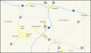
length_mi=14.49
length_round=2
length_ref=cite web |url=http://tpd.az.gov/data/reports/2006SHSLog.pdf |title=2006 ADOT Highway Log |author=Arizona Department of Transportation |accessdate=2008-04-09]
length_notes=
established=
decommissioned=
direction_a=South
starting_terminus=jct|state=AZ|I|17
junction=
direction_b=North
ending_terminus=jct|state=AZ|SR|89A in Sedona
previous_type=AZ
previous_route=177
next_type=AZ
next_route=180A
commons=State Route 179, also known as SR 179 and the Red Rock Scenic Byway, is a north-south state highway in
Arizona running from Interstate 17 north of Rimrock to SR 89A in Sedona. SR 179 is designated as anAll-American Road due to the sandstone formations through which it travels along its 7.5 mile length, which is within thePrescott National Forest .Route description
The southern terminus of SR 179 is located at exit 298 on I-17 northeast of Rimrock. It heads northwest from the interchange briefly before curving towards the north. It keeps this heading as it passes through the red rock area of Arizona on its way to Sedona. As it enters the Sedona city limits, it roughly follows along the east side of Oak Creek. It eventually crosses the creek just prior to reaching its northern terminus at SR 89A. [cite map|publisher=
Google Maps |title=Overview map of SR 179|accessdate=2008-04-17|url=]History
SR 179 originally continued south to Camp Verde. However, the southern section of the road was turned over to the
National Forest Service for maintenance after the construction of I-17.The road is currently being widened to a 4 lane divided highway between I-17 and Sedona, with 5 lanes located in the urban stretches in the village of Oak Creek and in Sedona. There are 8 roundabount intersections planned along the route. Construction is scheduled to be completed in 2009.
Junction list
References
External links
* [http://arizonaroads.com/arizona/az179.html SR 179 at Arizona Roads]

Wikimedia Foundation. 2010.