- Arizona State Route 143
Infobox road
marker_
state=AZ
highway_name=
name_notes=
type=state
route=143
alternate_name=Hohokam Expressway
maint=ADOT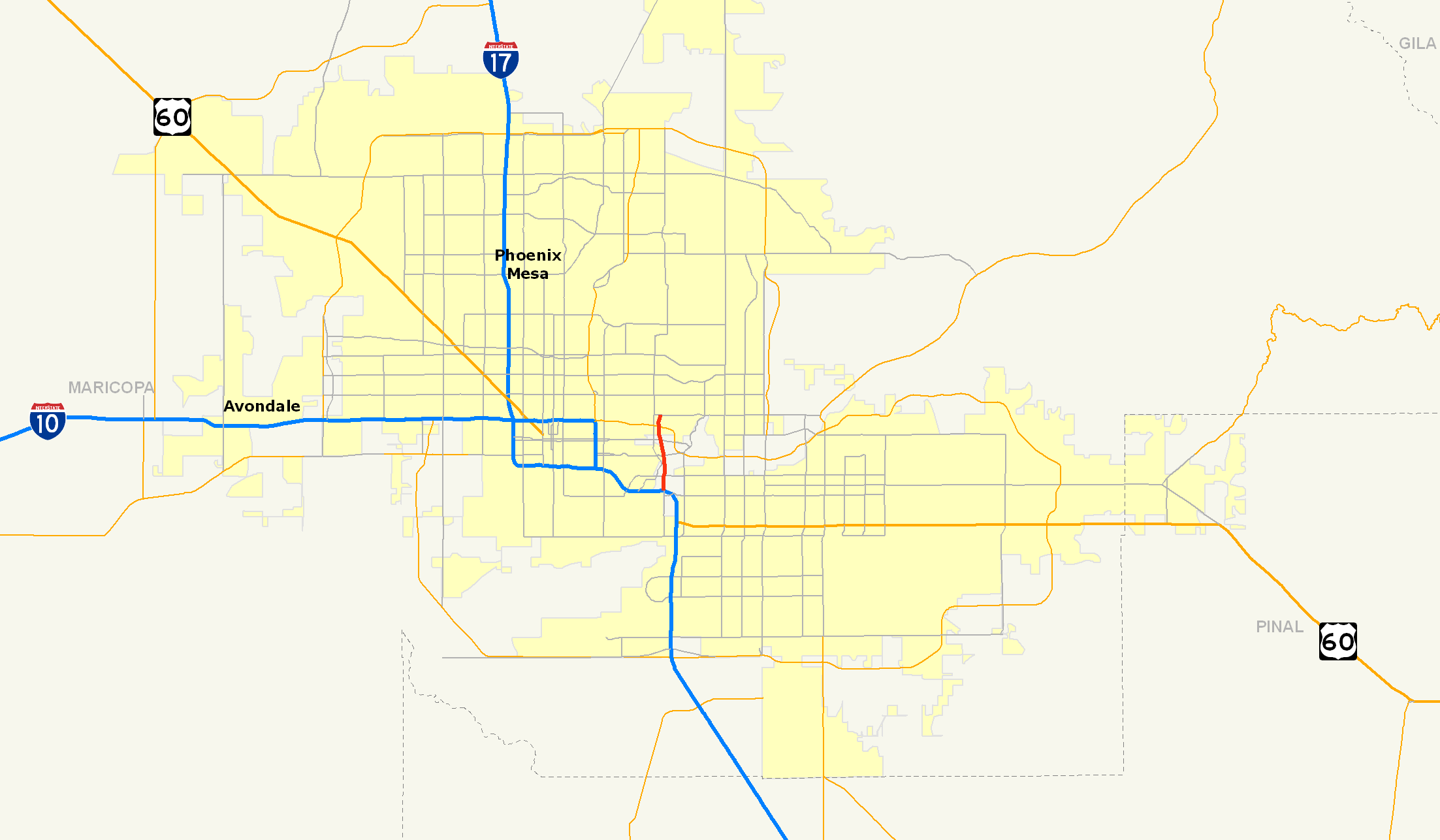
length_mi=3.93
length_round=2
length_ref=cite web |url=http://tpd.az.gov/data/reports/2006SHSLog.pdf |title=2006 ADOT Highway Log |author=Arizona Department of Transportation |accessdate=2008-04-09]
length_notes=
established=
decommissioned=
direction_a=North
starting_terminus=McDowell Rd
beltway_city=
junction=jct|state=AZ|I|10 in Phoenix
jct|state=AZ|SR|202 in Phoenix
direction_b=South
ending_terminus=jct|state=AZ|I|10 in Phoenix
counties=
cities=
system=
previous_type=AZ
previous_route=101
next_type=AZ
next_route=169
browse=
commons=State Route 143, also known as SR 143 and the Hohokam Expressway, is a north-south and access-controlled
freeway in Maricopa County,Arizona that runs from a junction with Interstate 10 at 48th Street in Phoenix to McDowell Road. The only other major junction along the 3.93-mile route is with Loop 202, which is located one half-mile south of McDowell Road and the northern terminus.The road lies directly to the east of
Phoenix Sky Harbor International Airport . Along with theSky Harbor Expressway (former SR 153), SR 143's primary purpose is to provide East Valley residents with access to Sky Harbor from westbound Interstate 10 and US 60. This removes the need to travel longer on constantly-congested I-10 and avoid the junction with Interstate 17's southern terminus.Route description
The Hohokam Expressway begins at an intersection with McDowell Road in Phoenix. The freeway continues southward to an ornately designed junction with the Red Mountain portion of Loop 202. Commuters are then allotted access to
Sky Harbor International Airport prior to the Salt River crossing.The southern half of SR 143 begins with the original interchange with University Drive, and then one with Interstate 10 and US 60. After these two interchanges, the freeway ends by transitioning into 48th Street, a surface street.
History
The Hohokam Expressway has a long history and gestation period. The road was first planned as part of the
1960 Phoenix Freeway plan as a collector road for traffic from the east side of Phoenix, as well as a proposed eastern exit from Sky Harbor Airport. The present-day interchange with Interstate 10 was completed in1967 as part of the original I-10freeway construction through the southeast sections of the valley such as the Tempe and Chandler suburbs. [ cite web
url = http://www.rockymountainroads.com/az-143.html
title = Hohokam Expressway
publisher = AARoads
accessdate = 2008-01-22 ]The final design was released in
1974 , when SR 143 was known as Business I-10 and not yet afreeway , but aparkway withtraffic signal s andintersection s. The design portrayed the new parkway leaving Interstate 10 north along 48th Street corridor, then angling across the Salt River to reach 44th Street where it was planned to end at Washington St. When it opened in1978 , it included the vital eastern access to Sky Harbor Airport, replacing the old 40th Street entrance that was eliminated when 40th Street was demolished to make way for a new airport terminal andrunway expansions. [ cite web
url = http://www.rockymountainroads.com/az-143.html
title = Hohokam Expressway
publisher = AARoads
accessdate = 2008-01-22 ]The new parkway rapidly earned a reputation as a constantly congested road, despite having only three traffic signals. As an attempt at decreasing congestion, a grade-separated interchange at University Drive was built in
1985 . The bridge was built to handle two lanes of traffic in each direction though without a shoulder or emergency lane. (This has been identified as a reason of the traffic backups still seen today, as the rest of the freeway is now built to three lanes on either side, thus creating a bottleneck at the University Drive overpass.)In 1985, the route was surveyed as part of the new
Maricopa Association of Governments 1985 Freeway Plan, and was added to the system with a reroute and upgrade tofreeway status. Business Loop I-10 was renamed to SR 143 and was realigned to meet up with the under construction Loop 202 at 48th Street, as opposed to the old 44th Street alignment. [ cite web
url = http://www.rockymountainroads.com/az-143.html
title = Construction Timeline
publisher = AARoads
accessdate = 2008-01-22 ]Construction timeline
*February
1991 : University Dr to the Sky Harbor Blvd
*November 1991: Sky Harbor Blvd to Washington St
*February1992 : Washington St to McDowell Rdafety concerns
At the southern terminus of the freeway, SR 143 begins at the intersection of 48th Street and Broadway, climbing over Interstate 10 on the original 48th Street bridge built in
1967 . There is no shoulder on thebridge and there is an original sign for University Dr, with oldbutton copy letters. Traffic heading southbound at this point is warned of a traffic signal that hides over theoptical horizon of the overpass to most traffic. To combat safety issues raised by the lack of visibility of the main traffic signals, a second traffic signal was installed at a higherelevation so that it is visible to traffic on the northern approach of the overpass. Included in this second signal is a high-intensity strobe embedded in the red signal. In addition to the strobing signal light,rumble strips have been cut into the bridge deck at several intervals, and there is a sign that turns on if the signal is red and the speed limit is reduced, further alerting traffic that the freeway is ending. [http://www.rockymountainroads.com/az-143.html]Part of the bridge deck is shared with an exit-only lane leading to a cloverleaf ramp to Interstate 10/US 60 Eastbound to Tucson, which has a ramp speed limit of only 25mph to access the freeway. Traffic is frequently backed up to University Drive from this exit, and has raised additional safety concerns of the intersection and highway junction. Also, the Broadway Road intersection is less than one quarter mile south of I-10. Traffic is currently backing up from that intersection to I-10, causing further delays and potential accidents due to the visibility and design of the bridge over I-10. ADOT is currently studying the redesign of the southern section of SR 143, including the infamous bridge, to the Sky Harbor Airport exit in an attempt to fix the numerous safety issues with the addition of collector-distributor lanes when the freeway is widened between
2009 and2012 . C/D lanes are also known to split a freeway into "local" and "express" lanes.Being that SR 143 connects the Red Mountain Freeway (Loop 202) to Interstate 10, this route is popular with local commuters seeking to bypass a stretch of Interstate 10 and US 60 between the
Mini Stack and theBroadway Curve , adding to additional traffic overload and safety issues at the interchange with SR 143/I-10/US 60. The speed limit on I-10 throughout the city of Phoenix is currently 55mph. Many other area freeways have limits of 65mph, notable exceptions being theSky Harbor Expressway with 45mph andInterstate 17 with 55mph. [ cite web
url = http://www.rockymountainroads.com/az-143.html
title = SR 143
publisher = AARoads
accessdate = 2008-01-22 ]Exit list
The entire route is in Phoenix, Maricopa County.
References
External links
* [http://www.rockymountainroads.com/az-143.html Hohokam Expressway Guide]
* [http://www.azdot.gov/Highways/Valley_Freeways/Freeway_Maps/SR143.asp SR 143 Construction Projects]See also
*
Hohokam
*Sky Harbor International Airport
*List of Arizona State Routes
Wikimedia Foundation. 2010.