- Mini Stack
-
Mini Stack 
The Mini Stack, looking north up State Route 51 in 2010.Location Phoenix, Arizona Coordinates: 33°27′44″N 112°2′15″W / 33.46222°N 112.0375°WCoordinates: 33°27′44″N 112°2′15″W / 33.46222°N 112.0375°W Roads at
junction: I-10
I-10
 SR 51
SR 51 SR 202
Construction Type: {{{type}}} Maintained by: ADOT Map 
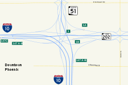
The Mini Stack is the freeway interchange among Interstate 10, State Route 51, and Loop 202 in Phoenix, Arizona, United States, located northeast of downtown.[1] Reconstructed in 2004 to its current setup, the interchange, which is the busiest in the state of Arizona with over 300,000 vehicles per day, provides full directional access between the three freeways as well as HOV lane connections for southbound SR 51 to eastbound I-10, westbound Loop 202 to westbound I-10, and eastbound I-10 to eastbound Loop 202.[2]
Contents
Description
The interchange constitutes exits 147A, 147B, and 147C on Interstate 10; exits 1 and 1A on Route 51; and exit 1A on Loop 202. The Mini Stack serves as the western terminus of Loop 202's Red Mountain Freeway segment and the southern terminus of the Piestewa Freeway, or Route 51.[3]
Interstate 10, the only through-route in this interchange, changes cardinal direction as it passes through the Mini Stack, heading from north to west for westbound travelers (where it is locally referred to as the Papago Freeway) and east to south for eastbound travelers (known locally as the Maricopa Freeway).
Delays
In a 2007 study performed by Forbes, the Mini Stack ranked number four in the United States in terms of delays with 22 million hours of delays each year. It was behind only Los Angeles' US 101 and I-405 interchange in California, Houston's I-610 and I-10 interchange in Texas, and Chicago's I-90/I-94 and I-290 interchange in Illinois.[4]
See also
References
- ^ Malone, Robert. "Phoenix I-10 and SR 51 interchange". Forbes. http://www.forbes.com/2007/06/11/traffic-highways-interstates-biz-logistics_cx_rm_0611traffic_slides_5.html?thisSpeed=30000. Retrieved 2008-02-01.
- ^ "State proposes an additional ten lanes for highway". East Valley Tribune. Archived from the original on 2008-05-02. http://web.archive.org/web/20080502015603/http://www.eastvalleytribune.com/story/84139. Retrieved 2008-03-18.
- ^ "Interstate 10 westbound - Maricopa County". AARoads. http://www.rockymountainroads.com/i-010wc_az.html. Retrieved 2008-02-01.
- ^ "America's 12 Worst Traffic Traps". Forbes. 2007-06-11. http://www.forbes.com/logistics/2007/06/11/traffic-highways-interstates-biz-logistics_cx_rm_0611traffic.html. Retrieved 2008-02-01.
External links
Roads and freeways in metropolitan Phoenix Radial Papago/Maricopa (I-10) • Black Canyon (I-17) • Piestewa (AZ 51) • Superstition (US 60) • Williams Gateway (AZ 24) • I-10 Reliever (AZ 30) • Sky Harbor (Former AZ 153)Circumferential Interchanges and other Categories:- Buildings and structures in Phoenix, Arizona
- Transportation in Phoenix, Arizona
- Interstate 10
- Road interchanges in the United States
Wikimedia Foundation. 2010.
