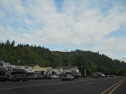
- Mapleton, Oregon
-
Mapleton — Unincorporated community — Location within the state of Oregon Coordinates: 44°1′52″N 123°51′57″W / 44.03111°N 123.86583°WCoordinates: 44°1′52″N 123°51′57″W / 44.03111°N 123.86583°W Country United States State Oregon County Lane Established 1886 Population (2000) – Total 918 Time zone Pacific (PST) (UTC-8) – Summer (DST) PDT (UTC-7) ZIP code 97453 Area code(s) 458 and 541 FIPS code GNIS feature ID Mapleton is an unincorporated community in Lane County, Oregon, United States. It is located on Oregon Route 126 and the Siuslaw River, 45 miles west of Eugene and 15 miles east of Florence.[1] It is also the western terminus of Oregon Route 36. As of the 2000 census, Mapleton had a total population of 918.[2]
History
Mapleton was likely named by Julia Ann Bean ("Grandma" Bean) for the abundance of Bigleaf Maple trees in the area.[3] Grandma Bean's husband was Obediah Roberts Bean, and their eldest child was judge Robert S. Bean.[3] Pioneers of 1852, the Beans moved to the Mapleton area in 1886 and the town was named shortly thereafter.[3] There was a post office called Seaton established north of the locality in 1885, and when it moved to the Mapleton area in 1889, Mrs. Bean became postmaster.[3] The post office was renamed Mapleton to match the town in 1896.[3]
References
- ^ "Mapleton, Oregon map and information". Oregon Hometown Locator. http://oregon.hometownlocator.com/or/lane/mapleton.cfm. Retrieved February 2010.
- ^ "Census 2000 Demographic Profile Highlights". United States Census Bureau. http://factfinder.census.gov/servlet/SAFFFacts?_event=Search&geo_id=86000US97461&_geoContext=01000US%7C86000US97461&_street=&_county=&_cityTown=&_state=&_zip=97453&_lang=en&_sse=on&ActiveGeoDiv=geoSelect&_useEV=&pctxt=fph&pgsl=860&_submenuId=factsheet_1&ds_name=DEC_2000_SAFF&_ci_nbr=null&qr_name=null®=null%3Anull&_keyword=&_industry=. Retrieved 2009-02-24.
- ^ a b c d e McArthur, Lewis A.; Lewis L. McArthur (2003) [1928]. Oregon Geographic Names (Seventh Edition ed.). Portland, Oregon: Oregon Historical Society Press. pp. 608–609. ISBN 0-87595-277-1.
External links
Municipalities and communities of Lane County, Oregon Cities Coburg | Cottage Grove | Creswell | Dunes City | Eugene | Florence | Junction City | Lowell | Oakridge | Springfield | Veneta | Westfir
Unincorporated
communitiesAlvadore | Belknap Springs | Blachly | Blue River | Brickerville | Cheshire | Cloverdale | Crow | Culp Creek | Cushman | Deadwood | Deerhorn | Dexter | Disston | Dorena | Elmira | Fall Creek | Finn Rock | Franklin | Gillespie Corners | Glenada | Glenwood | Goldson | Goshen | Greenleaf | Heceta Beach | Horton | Indiola | Jasper | Lancaster | Latham | Leaburg | Linslaw | London Springs | Lorane | Low Pass | Mabel | Mapleton | Marcola | McCredie Springs | McKenzie Bridge | Minerva | Mohawk | Nimrod | North Beach | Noti | Pleasant Hill | Rainbow | Riverview | Saginaw | Searose Beach | Siltcoos | Swisshome | Tide | Tiernan | Triangle Lake | Vaughn | Vida | Walden | Walker | Walterville | Walton | Wendling | Westlake
Ghost towns Categories:- Unincorporated communities in Lane County, Oregon
- Lane County, Oregon geography stubs
Wikimedia Foundation. 2010.


