- Oregon Route 410
-
"Oregon Route 220" redirects here. For the former unsigned Highway 220, see Mapleton-Eugene Highway.
Oregon Route 410
Route information Maintained by ODOT Length: 3.71 mi (5.97 km) Existed: 2003 – present Major junctions West end: Granite Hill Highway in Sumpter East end:  OR 7 near Sumpter
Highway system Oregon highways
Routes • Highways←  I-405
I-405OR 413  →
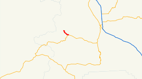
→Oregon Route 410 (OR 410) is an Oregon state highway running from Sumpter to OR 7 near Sumpter. OR 410 is known as the Sumpter Highway. It is 3.71 miles (5.97 km) long and runs east–west, entirely within Baker County.
OR 410 was established in 2003 as part of Oregon's project to assign route numbers to highways that previously were not assigned, and, as of July 2010, was unsigned.
Contents
Route description
OR 410 begins at the western city limits of Sumpter and heads east through Sumpter. It ends 1.83 miles (2.95 km) east of the eastern city limits at an intersection with OR 7.
History
The Sumpter Highway originally ran to the current intersection of OR 7 and OR 245 in Salisbury and was designated as OR 220. This designation was removed in the 1980s when the section east of the current terminus was redesignated as part of the Whitney Highway and OR 7. OR 410 was assigned to the Sumpter Highway in 2003.
Major intersections
Milepost City Intersection 0.00 Sumpter Begin Route 3.71 Near Sumpter OR 7 References
- Oregon Department of Transportation, Descriptions of US and Oregon Routes, http://www.oregon.gov/ODOT/HWY/TRAFFIC/TEOS_Publications/PDF/Descriptions_of_US_and_Oregon_Routes.pdf, page 30.
- Oregon Department of Transportation, Sumpter Highway No. 410, ftp://ftp.odot.state.or.us/tdb/trandata/maps/slchart_pdfs_1980_to_2002/Hwy410_2001.pdf
- Oregon Highways, Oregon Secondary State Routes (archive), http://web.archive.org/web/20050313200053/www.ylekot.com/orehwys/Routes_Secondary.html#ORE-220
Categories:- State routes in Oregon
- Transportation in Baker County, Oregon


Wikimedia Foundation. 2010.