- Oregon Route 39
-
For the unsigned Highway 39, see Salmon River Highway. For the former unsigned Highway 39, see Deschutes Highway.
Oregon Route 39
Route information Maintained by ODOT Length: 23.64 mi (38.04 km) Major junctions South end: 
 SR 139 and SR 161 near Merrill
 OR 140 in Klamath Falls
 US 97 Business in Klamath Falls
North end: US 97 in Klamath FallsHighway system Oregon highways
Routes • Highways←  OR 38
OR 38OR 42  →
→Oregon Route 39 is an Oregon state highway that runs between the city of Klamath Falls in Southern Oregon, and the California border between Merrill, Oregon and Tulelake, California.
Contents
Route description
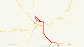
Oregon Route 39 begins at an interchange with U.S. Route 97, north of downtown Klamath Falls, and just west of the main campus of the Oregon Institute of Technology. For the first 5 miles (8.0 km) of its existence, it is an urban expressway, known locally as either Kit Carson Way or as the East Side Bypass, that skirts the eastern edge of Klamath Falls. The northernmost mile or so is shared with U.S. Route 97 Business, which departs from OR 39 and heads downtown via Esplanade Street.
East of the junction with Main Street, OR 39 continues in a southeasterly direction, skirting the main business district. The East Side Bypass ends at an intersection with 6th Street (OR 39 Business[citation needed]), in the eastern suburb of Altamont. OR 39 then heads east-southeast on 6th street for several more miles, until an intersection with Oregon Route 140. From U.S. Route 97, including the concurrency with U.S. 97 Business, to its departure from OR 140, including the concurrency, OR 39 consists of concurrent parts of the Klamath Falls-Malin Highway No. 50 (see Oregon highways and routes) and the Klamath Falls-Lakeview Highway No. 20.
At that intersection, OR 39 then turns due south, and is now known as the Klamath Falls-Malin Highway. OR 39 shares an alignment with OR 140 for about two miles (3 km), until OR 140 west diverges once again as the Southside Expressway. OR 39 then leave the Klamath Falls metropolitan area, and heads south-southeast for about 12 miles (19 km), until it reaches the town of Merrill. The highway then turns due east, running parallel to the California border. About 2 miles (3.2 km) east of Merrill, OR 39 and the Klamath Falls-Malin Highway depart; with the latter continuing east towards Malin, and OR 39 turning southeast. It runs southeast for 2 more miles as the Hatfield Highway No. 426 ending at the California border. The highway continues into California as State Route 139, which continues on to Tulelake, Canby, California, and other points in Northern California. At the state line is an intersection with State Route 161. Via State Route 299 and U.S. Route 395, one may continue on to Reno, Nevada.
History
At one point in the past, OR 39 (or its predecessor) continued east into Malin, Oregon from the junction between Malin and Merrill; then headed southeast (reuniting with SR 139 south of Tulelake, CA). This stretch of road continues to be known as the Klamath Falls-Malin Highway within Oregon, and has an ODOT Highway number (not a route number) of 50. It is unclear whether or not this highway will ever be signed.
Prior to the construction of the Eastside Bypass, OR 39 used to run through Klamath Falls via 6th Street, through downtown, exiting downtown via Oregon Avenue. (This also was a prior alignment for Oregon Route 140; Oregon Avenue continues west past US 97, until it ends at a junction with OR 140 west of town. Portions of this route are currently signed as OR 39 Business.[citation needed])
Major intersections
- Note: OR 39 uses several different highways (see Oregon highways and routes); the milepoint column shows mileage along these highways, not adjusted for equations, with the highway number in front.
The entire route is in Klamath County.
Location Milepoint[1] Destinations Notes 426 18.93 State line 426 16.51
50 16.51Malin (Klamath Falls-Malin Highway) 50 1.78 OR 140 west to US 97 – MedfordSouth end of OR 140 overlap 50 0.00 OR 140 east – Dairy, Lakeview, WinnemuccaNorth end of OR 140 overlap 50 -2.24 Klamath Falls (Klamath Falls-Lakeview Highway) Former OR 39 north/OR 140 west Klamath Falls 50 -4.97 
US 97 Bus. south – Klamath Falls City CenterSouth end of US 97 Bus. overlap 50 -6.81 US 97 north – BendInterchange References
- ^ Oregon Department of Transportation, Public Road Inventory (primarily the Digital Video Log), accessed March 2008
External links
Categories:- State routes in Oregon
- Transportation in Klamath County, Oregon


Wikimedia Foundation. 2010.