Oregon Route 234

Oregon Route 234

Oregon Route 234 marker

Oregon Route 234
Route information
Maintained by ODOT
Length: 17.78 mi (28.61 km)
Major junctions
West end: OR 99.svg OR 99 near Gold Hill
  I-5 (big).svg I-5 in Gold Hill
East end: OR 62.svg OR 62 near Eagle Point
Highway system

Oregon highways
Routes • Highways

OR 233 OR 237

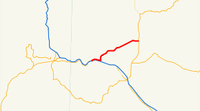
Oregon Route 234 is an Oregon state highway which runs between the city of Gold Hill, Oregon and the town of Eagle Point. It is known as the Sams Valley Highway No. 271 (see Oregon highways and routes), and is 18 miles (29 km) long. It lies entirely in Jackson County

Route description

OR 234 begins, at its western terminus, at an interchange with Interstate 5 in Gold Hill. For the first several miles of the highway's existence, it is concurrent with Oregon Route 99, which departs from the freeway to serve Gold Hill. In the city center, OR 234 and OR 99 diverge; with the latter returning to the freeway. OR 234 then heads northeast, passing through the northern edge of the Rogue Valley and the Cascade foothills. It passes nearby the community of Sams Valley, and ends at an intersection with Oregon Route 62, north of Eagle Point.

Intersections with other highways

  • I-5 and OR 99 in Gold Hill
  • OR 62 in Eagle Point

Wikimedia Foundation. 2010.

Игры ⚽ Нужна курсовая?

Look at other dictionaries:

  • Oregon Route 99E — Route information Maintained by …   Wikipedia

  • Oregon Route 99 — This article is about OR 99 south of Junction City. For the split routes north of Junction City, see Oregon Route 99E and Oregon Route 99W. For the former U.S. Route, see U.S. Route 99 in Oregon. Oregon Route 99 …   Wikipedia

  • Oregon Route 62 — For the unsigned Highway 62, see Florence Eugene Highway. Oregon Route 62 Route information …   Wikipedia

  • Oregon Route 237 — For the former unsigned Highway 237, see Myrtle Creek Highway. Oregon Route 237 Route information …   Wikipedia

  • Oregon Route 233 — For the unsigned Highway 233, see West Diamond Lake Highway. Oregon Route 233 Route information …   Wikipedia

  • Oregon's 1st congressional district — OR 1 redirects here. For Oregon Route 1, see Pacific Highway (U.S.). Oregon s 1st congressional district District map as of 2002 Current Representative vacant Area …   Wikipedia

  • Course of the Rogue River (Oregon) — This article is about the course of the river in Southern Oregon. For the river in Polk County, Oregon, see Rogue River (South Yamhill River). Coordinates: 42°25′21″N 124°25′45″W /  …   Wikipedia

  • List of highways numbered 234 — The following highways are numbered 234: United States California State Route 234 (unbuilt) Florida State Road 234 (former) Georgia State Route 234 …   Wikipedia

  • Sams Valley, Oregon — Sams Valley is an unincorporated community in Jackson County, Oregon, United States, on Oregon Route 234 northeast of Gold Hill, in the Medford area.Originally named Moonville ,cite news |url=http://archive.mailtribune.com/archive/99/sept99/91999n… …   Wikipedia

  • Liste der State-, U.S.- und Interstate-Highways in Oregon — Die I 5 in der Nähe des Mount Shasta Die Liste der State, U.S. und Interstate Highways in Oregon ist eine Aufstellung von State Highways in Oregon, USA nach Art und Nummer. Das Straßennetz wird von der Highway Division der Behörde Oregon… …   Deutsch Wikipedia

Share the article and excerpts

Direct link
Do a right-click on the link above
and select “Copy Link”