- Oregon Route 244
-
For the unsigned Highway 244, see Coquille-Bandon Highway.
Oregon Route 244 
Route information Maintained by ODOT Length: 47.22 mi (75.99 km) Major junctions West end:  US 395 near Ukiah
East end: 
 I-84 / US 30 in Hilgard
Highway system Oregon highways
Routes • Highways←  OR 242
OR 245  →
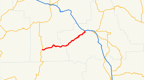
→Oregon Route 244 is an Oregon state highway running from Ukiah in Umatilla County to Hilgard in Union County. OR 244 is known as the Ukiah-Hilgard Highway No. 341 (see Oregon highways and routes). It is 47.22 miles (75.99 km) long and runs east–west.
Contents
Route description
OR 244 begins at an intersection with US 395 one mile (1.6 km) west of Ukiah and continues east and northeast to Hilgard, where it ends at an intersection with Interstate 84.
History
This is the 2nd Oregon Route to use the number 244. The first OR 244 was located in suburban Portland, connecting U.S. 99W near Tualatin with OR 43 in West Linn. This route later became part of an extended Oregon Route 212, but was deleted from the state highway system after Interstate 205 (Oregon-Washington) was completed.
Major intersections
Milepost City Intersection 0.00 Near Ukiah US 395 47.22 Hilgard Interstate 84 and U.S. Route 30 References
- Oregon Department of Transportation, Descriptions of US and Oregon Routes, http://www.oregon.gov/ODOT/HWY/TRAFFIC/TEOS_Publications/PDF/Descriptions_of_US_and_Oregon_Routes.pdf, page 22.
- Oregon Department of Transportation, Ukiah-Hilgard Highway No. 341, ftp://ftp.odot.state.or.us/tdb/trandata/maps/slchart_pdfs_1980_to_2002/Hwy341_1996.pdf
Categories:- State routes in Oregon
- Transportation in Umatilla County, Oregon
- Transportation in Union County, Oregon
Wikimedia Foundation. 2010.

