- Oregon Route 141
-
Oregon Route 141 
Route information Maintained by ODOT Length: 10.46 mi (16.83 km) Existed: 2003 – present Major junctions South end:  I-5 in Wilsonville
 OR 99W in Tigard
 OR 217 in Tigard
North end:  OR 217 in Beaverton
Highway system Oregon highways
Routes • Highways←  OR 140
OR 153  →
→Oregon Route 141, known as the Beaverton-Tualatin Highway No. 141 (see Oregon highways and routes), is an Oregon state highway which serves runs (contrary to its name) from the city of Wilsonville, Oregon to the southern edge of Beaverton. The highway is 10.46 miles (16.83 km) long.
Oregon Route 141 is a post-2002 number, and as of June 2011, does not have route markers posted.
Contents
Route description
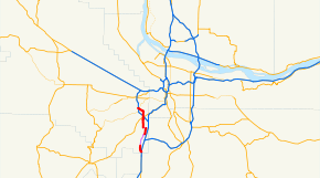
The southern terminus of Oregon Route 141 is at Exit 286 on Interstate 5 in northern Wilsonville. From there, the highway runs north along Boones Ferry Road, through the city of Tualatin and past the community of Durham. In Durham, it then turns west on Durham Road for approximately one mile, then turns north again Hall Boulevard in Tigard. It then heads north on Hall for several miles, crossing OR 99W in Tigard, and eventually ending at an intersection with OR 210 (Scholls Ferry Road) in the community of Progress (though the intersection is technically within the city of Beaverton). An interchange with OR 217 lies nearby.
Just north of the intersection with OR 99W, the highway crosses over, but does not intersect with, OR 217; however access to OR 217 at this point is provided via OR 99W.
This route, along with a further extension north into Beaverton on Hall Boulevard, and a further extension south into Woodburn via Boones Ferry Road, was the original route of OR 217, before the current freeway alignment was constructed in 1972.
As of 2006, route markers are not posted for this highway anywhere along its length. Complicating the definition of the highway, two separate sections of the route are maintained by cities (Tualatin and Tigard), and are technically not part of the official definition of OR 141.
Intersections with other highways
- I-5 in Wilsonville
- OR 99W in Tigard
- OR 210 in Beaverton
- OR 217 in Beaverton
History
Prior to the opening of the current OR 217 freeway in the 1970s, the entire route of OR 141 was part of the original OR 217 that connected OR 8 in Beaverton to OR 99E in Aurora.
External links
Categories:- State routes in Oregon
- Transportation in Washington County, Oregon
Wikimedia Foundation. 2010.

