- Durham, Oregon
-
Durham, Oregon — City — City hall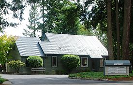 Location in Oregon
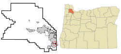
Coordinates: 45°23′40″N 122°45′31″W / 45.39444°N 122.75861°WCoordinates: 45°23′40″N 122°45′31″W / 45.39444°N 122.75861°W Country United States State Oregon County Washington Incorporated 1966 Government – Mayor Gery Schirado Area – Total 0.4 sq mi (1.1 km2) – Land 0.4 sq mi (1.1 km2) – Water 0 sq mi (0 km2) Elevation 197 ft (60.05 m) Population (2007) – Total 1,395 – Density 3,144.3/sq mi (1,212.7/km2) Time zone Pacific (UTC-8) – Summer (DST) Pacific (UTC-7) ZIP code 97224 Area code(s) 503 and 971 FIPS code 41-21250[1] GNIS feature ID 1120224[2] Website www.durham-oregon.us Durham is a city in Washington County, Oregon, United States. Incorporated in 1966, the city is surrounded by Tigard and Tualatin and is adjacent to the Bridgeport Village shopping complex. The population was 1,382 at the 2000 census. The 2007 estimate is 1,395 residents.[3]
Contents
History
The city was named for Albert Alonzo Durham, founder of the nearby town of Oswego.[4] Durham operated a sawmill and a flour mill on Fanno Creek, which flows through the city, from 1866 until his death in 1898.[5] The site, located along the Boones Ferry Road to Portland, was originally known as Durhams Mills.[6] In 1908, the Oregon Electric Railway established a stop called Durham at the location.[5] Residents of the city voted for incorporation in 1966 to protect the location from industrialization of its residential areas. Today, the community is primarily residential.[5]
Geography
According to the United States Census Bureau, the city has a total area of 0.4 square miles (1.0 km2), all of it land.[7] It sits at 197 feet (60 m) above sea-level.[8] The main road through Durham is Upper Boones Ferry Road, with Interstate 5 about .5 miles (0.80 km) east of the city.[9] Part of the western boundary of the city is the Tualatin River, with the only park, Durham City Park, also on the western edge of Durham.
Government
Durham's mayor is Gery Schirado and the city administrator is Roland Signett.[8][10] Children in the community attend the schools of the Tigard-Tualatin School District.[11] The city's police protection is provided under contract by the Tualatin Police Department,[10] and fire protection is provided by Tualatin Valley Fire & Rescue.[11] The city is part of the Tigard Water District for drinking water, while wastewater treatment is provided by Clean Water Services.[11] Durham's annual budget is around $2.4 million.[9]
Demographics
As of the census[1] of 2000, there were 1,382 people, 528 households, and 391 families residing in the city. The population density was 3,144.3 people per square mile (1,212.7/km²). There were 552 housing units at an average density of 1,255.9 per square mile (484.4/km²). The racial makeup of the city was 89.29% White, 0.80% African American, 0.72% Native American, 1.66% Asian, 0.36% Pacific Islander, 3.18% from other races, and 3.98% from two or more races. Hispanic or Latino of any race were 7.81% of the population.
There were 528 households out of which 43.2% had children under the age of 18 living with them, 56.8% were married couples living together, 14.4% had a female householder with no husband present, and 25.8% were non-families. 18.9% of all households were made up of individuals and 3.2% had someone living alone who was 65 years of age or older. The average household size was 2.62 and the average family size was 3.01.
In the city the population was spread out with 30.9% under the age of 18, 6.5% from 18 to 24, 29.6% from 25 to 44, 27.1% from 45 to 64, and 5.9% who were 65 years of age or older. The median age was 34 years. For every 100 females there were 94.1 males. For every 100 females age 18 and over, there were 87.3 males.
The median income for a household in the city was $51,806, and the median income for a family was $64,531. Males had a median income of $59,712 versus $33,750 for females. The per capita income for the city was $29,099. About 10.2% of families and 10.8% of the population were below the poverty line, including 14.7% of those under age 18 and 13.7% of those age 65 or over.
References
- ^ a b "American FactFinder". United States Census Bureau. http://factfinder.census.gov. Retrieved 2008-01-31.
- ^ "US Board on Geographic Names". United States Geological Survey. 2007-10-25. http://geonames.usgs.gov. Retrieved 2008-01-31.
- ^ PSU:Population Research Center
- ^ Foster, Laura O. (2009). Lake Oswego. Arcadia Publishing. p. 15. ISBN 9780738570853. http://books.google.com/books?id=l54TF_FfjzcC.
- ^ a b c "City of Durham". City of Durham, Oregon. http://www.durham-oregon.us/. Retrieved January 18, 2010.
- ^ McArthur, Lewis A.; McArthur, Lewis L. (2003) [First published 1928]. Oregon Geographic Names (7th ed.). Portland, Oregon: Oregon Historical Society Press. p. 309. ISBN 9780875952772. OCLC 53075956.
- ^ "US Gazetteer files: 2010, 2000, and 1990". United States Census Bureau. 2011-02-12. http://www.census.gov/geo/www/gazetteer/gazette.html. Retrieved 2011-04-23.
- ^ a b "Incorporated Cities: Durham". Oregon Blue Book. Oregon State Archives. http://bluebook.state.or.us/local/cities/ad/durham.htm. Retrieved 2 February 2010.
- ^ a b "Welcome". City of Durham. http://www.durham-oregon.us/. Retrieved 2 February 2010.
- ^ a b Oram, Bill (January 29, 2010). "Durham: Call a cop, Tualatin wants all our money". The Oregonian. http://www.oregonlive.com/tualatin/index.ssf/2010/01/durham_call_a_cop_tualatin_wants_all_our_money.html. Retrieved 2 February 2010.
- ^ a b c "Durham Community Profile". Infrastructure Finance Authority. Business Oregon. http://www.orinfrastructure.org/profiles/Durham/. Retrieved 2 February 2010.
External links
 Media related to Durham, Oregon at Wikimedia Commons
- Entry for Durham in the Oregon Blue Book
Municipalities and communities of Washington County, Oregon Cities Banks | Beaverton | Cornelius | Durham | Forest Grove | Gaston | Hillsboro | King City | Lake Oswego‡ | North Plains | Portland‡ | Rivergrove‡ | Sherwood | Tigard | Tualatin‡ | Wilsonville‡
CDPs Aloha | Bethany | Bull Mountain | Cedar Hills | Cedar Mill | Garden Home-Whitford | Metzger | Oak Hills | Raleigh Hills | Rockcreek | West Haven-Sylvan | West Slope
Unincorporated
communitiesBlooming | Bonny Slope | Buxton | Carnation | Cherry Grove | Dilley | Farmington | Gales Creek | Glenwood | Hayward | Helvetia | Kansas City | Kinton | Laurel | Laurelwood | Manning | Marlene Village | Middleton | Midway | Mountaindale | Mulloy | Norwood | Roy | Scholls | Timber | Tonquin | Verboort | West Union | Wilkesboro
Ghost towns Dixie | Greenville | Thatcher
Footnotes ‡This populated place also has portions in an adjacent county or counties
Categories:- Cities in Oregon
- Populated places in Washington County, Oregon


Wikimedia Foundation. 2010.