- Cherry Grove, Oregon
-
Cherry Grove — Unincorporated community — A church in the community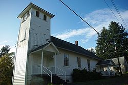 Location within the state of Oregon
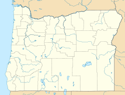
 Cherry Grove
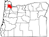
Coordinates: 45°26′52″N 123°14′32″W / 45.44778°N 123.24222°WCoordinates: 45°26′52″N 123°14′32″W / 45.44778°N 123.24222°W Country United States State Oregon County Washington Time zone Pacific (PST) (UTC-8) – Summer (DST) PDT (UTC-7) ZIP code 97119 Area code(s) 503 and 971 FIPS code GNIS feature ID Cherry Grove is an unincorporated community in Washington County, Oregon, United States. Cherry Grove is situated on the north bank of the Tualatin River near where it exits the Northern Oregon Coast Range and enters Patton Valley.
Cherry Grove was founded by Swedish immigrant August Lovegren in 1911. He had previously operated a lumber mill in Preston, Washington, after arriving in the United States in 1883. He wanted a name for the community that was connected with fruit growing, but his choice of "Appleton" was already taken by a place in Oregon. His cousin then suggested the name of her home of Cherry Grove, Minnesota.
Lovegren established a sawmill in the community and in September 1911 began operating a private electricity grid in Cherry Grove.[1] He used the sawmill's boiler in the operation, and in in September 1913 completed a dam on the Tualatin River to create a large log retention pond.[1] In January 1914, a flood destroyed both the dam and the boiler, leaving the community without electricity until Portland General Electric added service in 1935.[1] Cherry Grove's post office ran from 1912 through 1959 when service was transferred to Gaston.[2][3]
References
- ^ a b c Richert-Boe, Paul (1977-07-19). "Locally owned plants generated county's first electrcity". The Oregonian: p. B4W.
- ^ McArthur, Lewis A.; Lewis L. McArthur (2003) [1928]. Oregon Geographic Names (Seventh Edition ed.). Portland, Oregon: Oregon Historical Society Press. ISBN 0-87595-277-1.
- ^ Benson, Robert L. (October 19, 1976). "Business and Industry: Post offices, zip codes listed". Hillsboro Argus: p. 11.
Further reading
- Nixon, Birgetta & Mabel Tupper. Cherry Grove - A history from 1852 - 1977 (Cherry Grove, Oregon: 1977)
External links
- Historic photos of Cherry Grove from Salem Public Library
- Information about Cherry Grove and the Willamette Valley & Coast Railway from Abandoned Railways of the Pacific Northwest
- Cherry Grove history from VanNatta Forestry
- Several images of the falls on the Tualatin River above Cherry Grove from the Oregon State University Archives
Municipalities and communities of Washington County, Oregon Cities Banks | Beaverton | Cornelius | Durham | Forest Grove | Gaston | Hillsboro | King City | Lake Oswego‡ | North Plains | Portland‡ | Rivergrove‡ | Sherwood | Tigard | Tualatin‡ | Wilsonville‡
CDPs Aloha | Bethany | Bull Mountain | Cedar Hills | Cedar Mill | Garden Home-Whitford | Metzger | Oak Hills | Raleigh Hills | Rockcreek | West Haven-Sylvan | West Slope
Unincorporated
communitiesBlooming | Bonny Slope | Buxton | Carnation | Cherry Grove | Dilley | Farmington | Gales Creek | Glenwood | Hayward | Helvetia | Kansas City | Kinton | Laurel | Laurelwood | Manning | Marlene Village | Middleton | Midway | Mountaindale | Mulloy | Norwood | Roy | Scholls | Timber | Tonquin | Verboort | West Union | Wilkesboro
Ghost towns Dixie | Greenville | Thatcher
Footnotes ‡This populated place also has portions in an adjacent county or counties
Categories:- Unincorporated communities in Washington County, Oregon
- Oregon geography stubs


Wikimedia Foundation. 2010.