- North Plains, Oregon
-
North Plains, Oregon — City — City Hall
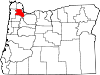
Nickname(s): City to the Sunset Location in Oregon
Coordinates: 45°35′50″N 122°59′53″W / 45.59722°N 122.99806°WCoordinates: 45°35′50″N 122°59′53″W / 45.59722°N 122.99806°W Country United States State Oregon County Washington Incorporated 1963 Government – Mayor David Hatcher Area – Total 0.8 sq mi (2.0 km2) – Land 0.8 sq mi (2.0 km2) – Water 0 sq mi (0 km2) Elevation 176 ft (53.6 m) Population (2000) – Total 1,605 – Estimate (2007) 1,813 – Density 2,044.7/sq mi (794.5/km2) Time zone Pacific (UTC-8) – Summer (DST) Pacific (UTC-7) ZIP code 97133 Area code(s) 503 FIPS code 41-53150[1] GNIS feature ID 1163180[2] Website www.northplains.org North Plains is a city in Washington County, Oregon, United States, off U.S. 26 on the northwest outskirts of the Portland metropolitan area. The population was 1,605 at the 2000 census; by July 2007 the population was estimated to be 1,813.[3]
Contents
Geography
According to the United States Census Bureau, the city has a total area of 0.8 square miles (2.1 km2), all of it land.
History
What was to become the city of North Plains was first platted in September 1910 by the Ruth Trust Company of Portland, which purchased area tracts after James J. Hill made plans to extend United Railways there.[4][5]
Pumpkin Ridge Golf Club, located just outside of town, was where David Duval won the Nike Tour Championship in 1993, and was home to the U.S. Women's Open in 1997 and 2003.[6] Horning's Hideout within the North Plains area was home to Faerieworlds Festival 2004[7]
Demographics
 North Plains Library.
As of the census[1] of 2000, there were 1,605 people, 594 households, and 422 families residing in the city. The population density was 2,044.7 people per square mile (794.5/km²). There were 633 housing units at an average density of 806.4 per square mile (313.3/km²). The racial makeup of the city was 90.78% White, 1.87% Asian, 1.68% Native American, 0.12% African American, 0.12% Pacific Islander, 2.74% from other races, and 2.68% from two or more races. Hispanic or Latino of any race were 7.10% of the population. On a percentage basis, North Plains is among the top 100 locations (with at least 500 residents) home to Panamanian Americans.[8]
There were 594 households out of which 40.9% had children under the age of 18 living with them, 58.8% were married couples living together, 8.8% had a female householder with no husband present, and 28.8% were non-families. 25.6% of all households were made up of individuals and 12.1% had someone living alone who was 65 years of age or older. The average household size was 2.70 and the average family size was 3.24.
In the city the population was spread out with 30.0% under the age of 18, 5.6% from 18 to 24, 35.0% from 25 to 44, 18.8% from 45 to 64, and 10.7% who were 65 years of age or older. The median age was 34 years. For every 100 females there were 97.7 males. For every 100 females age 18 and over, there were 92.3 males.
The median income for a household in the city was $49,563, and the median income for a family was $55,156. Males had a median income of $42,237 versus $27,857 for females. The per capita income for the city was $18,794. About 4.8% of families and 5.3% of the population were below the poverty line, including 3.8% of those under age 18 and 15.8% of those age 65 or over.
References
- ^ a b "American FactFinder". United States Census Bureau. http://factfinder.census.gov. Retrieved 2008-01-31.
- ^ "US Board on Geographic Names". United States Geological Survey. 2007-10-25. http://geonames.usgs.gov. Retrieved 2008-01-31.
- ^ Annual Estimates of the Population for Incorporated Places in Oregon from the U.S. Census Bureau
- ^ "North Plains History". Hillsboro Argus article dated June 25, 1963. City of North Plains. http://www.northplains.org/index.php/about-north-plains/city-history. Retrieved 2009-08-04. "The brochure points out in part that six months after the first train was run over the United Railways in January 1911, "The new town boasted a permanent population of 200 and after a year's growth North Plains is a thriving town of 400."...[The first plat was drawn in] September 1910 by Newell Gossett & Walsh Engineers for the Ruth Trust Co."
- ^ According to the Pacific Northwest Chapter of the National Railway Historical Society, United Railways was a Portland area short line that "operated one streetcar line, industrial trackage in Portland, and a logging and passenger line from northwest Portland to Banks, Vernonia, Keasey and beyond." The passenger service operated out of North Bank Station, a former freight-only depot at the corner of NW 11th and Hoyt, now known as the Pearl Townhouses. In 1944, United Railways was taken over by Spokane, Portland and Seattle Railway.
- ^ 2003 Fact Sheet from the U.S. Women's Open Championship website
- ^ Review of Faerieworlds Festival 2004 from the Faerieworlds website
- ^ Top 101 cities with the most residents born in Panama (population 500+) from city-data.com
External links
 Media related to North Plains, Oregon at Wikimedia Commons
- North Plains Public Library
- North Plains Chamber of Commerce
Municipalities and communities of Washington County, Oregon Cities Banks | Beaverton | Cornelius | Durham | Forest Grove | Gaston | Hillsboro | King City | Lake Oswego‡ | North Plains | Portland‡ | Rivergrove‡ | Sherwood | Tigard | Tualatin‡ | Wilsonville‡
CDPs Aloha | Bethany | Bull Mountain | Cedar Hills | Cedar Mill | Garden Home-Whitford | Metzger | Oak Hills | Raleigh Hills | Rockcreek | West Haven-Sylvan | West Slope
Unincorporated
communitiesBlooming | Bonny Slope | Buxton | Carnation | Cherry Grove | Dilley | Farmington | Gales Creek | Glenwood | Hayward | Helvetia | Kansas City | Kinton | Laurel | Laurelwood | Manning | Marlene Village | Middleton | Midway | Mountaindale | Mulloy | Norwood | Roy | Scholls | Timber | Tonquin | Verboort | West Union | Wilkesboro
Ghost towns Dixie | Greenville | Thatcher
Footnotes ‡This populated place also has portions in an adjacent county or counties
Categories:- Cities in Oregon
- Populated places in Washington County, Oregon


Wikimedia Foundation. 2010.