- Sherwood, Oregon
Infobox Settlement
official_name = Sherwood, Oregon
settlement_type =City
nickname =
motto =
imagesize =
image_caption =
image_
imagesize =
image_caption =
image_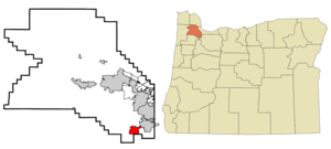
mapsize = 250px
map_caption = Location inOregon
mapsize1 =
map_caption1 =
subdivision_type = Country
subdivision_name =United States
subdivision_type1 = State
subdivision_name1 =Oregon
subdivision_type2 = County
subdivision_name2 = Washington
government_type =
leader_title =Mayor
leader_name = Keith Mays
established_title = Incorporated
established_date =1893
area_magnitude =
area_total_sq_mi = 4.1
area_total_km2 = 10.5
area_land_sq_mi = 4.1
area_land_km2 = 10.5
area_water_sq_mi = 0
area_water_km2 = 0
area_urban_sq_mi =
area_urban_km2 =
area_metro_sq_mi =
area_metro_km2 =
population_footnotes =
population_as_of =2006
population_note =
population_total = 16115
population_metro =
population_urban =
population_density_km2 = 1534.8
population_density_sq_mi = 3930.5
timezone = Pacific
utc_offset = -8
timezone_DST = Pacific
utc_offset_DST = -7
latd = 45 |latm = 21 |lats = 25 |latNS = N
longd = 122 |longm = 50 |longs = 36 |longEW = W
elevation_m = 58.8
elevation_ft = 193
website = [http://www.ci.sherwood.or.us http://www.ci.sherwood.or.us]
postal_code_type =ZIP code
postal_code = 97140
area_code = 503
blank_name = FIPS code
blank_info = 41-67100GR|2
blank1_name = GNIS feature ID
blank1_info = 1126877GR|3
footnotes =Sherwood is a city in Washington County,
Oregon ,United States . It is a residential community in the Tualatin Valley southwest of Portland. The population was 11,791 at the 2000 census. The 2006 estimate is 16,115 residents. [http://www.pdx.edu/media/p/r/PRC_Certified_Cities_2006.pdf PSU:Population Research Center] ]History
What is now the Sherwood area was originally inhabited by the
Atfalati band of theKalapuya nation. The first significant wave ofUnited States emigrants arrived in [http://www.historyglobe.com/ot/otmap1.htm 1843] . Native Americans were relocated to reservations after theDonation Land Claim Act of 1850-5 gave American citizens exclusive ownership of these lands. The relocation process took place under the guidance of a series of interesting federal employees, most notably Superintendent of Indian AffairsJoel Palmer , who was severely criticized for his humane treatment of the tribes.The
California Gold Rush of 1849 caused a dramatic shift in the area's economy.Oregon City, Oregon is located on a stretch of theWillamette River that had always been attractive to trade since prehistoric times, when trading activity was dominated by theChinookan tribe. When settlers of European extraction began arriving in large numbers, Oregon City became (arguably) the [http://www.endoftheoregontrail.org/ "End of the Oregon Trail"] . After the Gold Rush, however,Portland, Oregon replaced Oregon City as the area's most important center of trade and commerce. Sherwood sits within twenty miles of either metropolis.The name "Sherwood" arose from a declination of naming the town "Smock Ville" after its co-founders James Christopher and Mary Ellen Smock. In 1885, the Smocks gave a right-of-way on their property to the [http://gesswhoto.com/ohs-railroad.html Portland and Willamette Valley railway] . The Smocks platted the town in 1889, the same year rail service began. Tradition has it that no one, not even the town's founders, liked the name "Smock Ville," and so a public meeting was held to rename the town. A prominent businessman, Robert Alexander, suggested the name "Sherwood." According to Post Office records, Alexander was from
Sherwood, Michigan , and this was the town that was named afterSherwood Forest England. The U. S. Postal Department began sending mail to the Town of Sherwood, Oregon onJuly 5 ,1891 . Smock was the first postmaster. The Town of Sherwood was incorporated under [http://www.clydeburger.com/map/subset/documents/charter1893.htm Oregon Senate Bill 36] in 1893. She was incorporated in 1926 as the City of Sherwood, owing to a number of conflicts, most notably with the19th Amendment to the United States Constitution .The main industry in the 1890s was a pressed brick yard which closed in 1896, a victim of [http://eh.net/encyclopedia/article/whitten.panic.1893 the deep recession of 1893] . After the economic jump start of the
Klondike Gold Rush of 1897, the Town of Sherwood began to feature many of the small town qualities that were so fondly remembered by artists and intellectuals in later years. In 2007, a nationwide magazine placed Sherwood among the twenty most livable towns in America ("Money," July 2007). The population of the city in 1911 was 350 within a 1 square mile city limit. In 2004, the population had grown to 14,050 people and 4.5 square miles.Geography
Sherwood is located at coor dms|45|21|25|N|122|50|36|W|city (45.357024, -122.843261).GR|1
According to the
United States Census Bureau , the city has a total area of 4.1square mile s (10.5km² ), all of it land.Demographics
As of the
census GR|2 of 2000, there were 11,791 people, 4,253 households, and 3,300 families residing in the city. Thepopulation density was 2,895.5 people per square mile (1,118.6/km²). There were 4,412 housing units at an average density of 1,083.4/sq mi (418.5/km²). The racial makeup of the city was 92.36% White, 0.43% African American, 0.51% Native American, 2.22% Asian, 0.04% Pacific Islander, 1.76% from other races, and 2.67% from two or more races. Hispanic or Latino of any race were 4.72% of the population.There were 4,253 households out of which 46.3% had children under the age of 18 living with them, 65.7% were married couples living together, 8.8% had a female householder with no husband present, and 22.4% were non-families. 17.0% of all households were made up of individuals and 5.4% had someone living alone who was 65 years of age or older. The average household size was 2.77 and the average family size was 3.14.
In the city the population was spread out with 31.7% under the age of 18, 5.5% from 18 to 24, 41.2% from 25 to 44, 16.4% from 45 to 64, and 5.3% who were 65 years of age or older. The median age was 31 years. For every 100 females there were 95.4 males. For every 100 females age 18 and over, there were 92.9 males.
Portland State University's Population Research Center estimates the population at
July 1 ,2005 at 14,940.The median income for a household in the city was $62,518, and the median income for a family was $67,277. Males had a median income of $47,920 versus $33,657 for females. The
per capita income for the city was $25,793. About 1.5% of families and 2.7% of the population were below thepoverty line , including 2.0% of those under age 18 and 11.7% of those age 65 or over.chools
There are three elementary schools (J. Clyde Hopkins, Middleton, Archer Glen), soon to be four, one middle school (Sherwood Middle School), soon to be two, and one high school, Sherwood High School, in Sherwood. Each elementary school holds around 600 students, the middle school has about 1000, and the high school has an enrollment of 1200.
References
External links
* [http://www.ci.sherwood.or.us City of Sherwood]
Wikimedia Foundation. 2010.