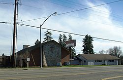
- Marlene Village, Oregon
-
Marlene Village, Oregon — Unincorporated community — Village Church in the community Coordinates: 45°31′01″N 122°49′08″W / 45.517°N 122.819°WCoordinates: 45°31′01″N 122°49′08″W / 45.517°N 122.819°W Country United States State Oregon County Washington Elevation 230 ft (70 m) Time zone Pacific (PST) (UTC-8) – Summer (DST) PDT (UTC-7) ZIP code 97006, 97229 Area code(s) 503 and 971 Marlene Village is an unincorporated community in Washington County, Oregon, United States.[1] It is located immediately northwest of Cedar Hills and south of the Sunset Highway (U.S. 26).
References
Municipalities and communities of Washington County, Oregon Cities Banks | Beaverton | Cornelius | Durham | Forest Grove | Gaston | Hillsboro | King City | Lake Oswego‡ | North Plains | Portland‡ | Rivergrove‡ | Sherwood | Tigard | Tualatin‡ | Wilsonville‡
CDPs Aloha | Bethany | Bull Mountain | Cedar Hills | Cedar Mill | Garden Home-Whitford | Metzger | Oak Hills | Raleigh Hills | Rockcreek | West Haven-Sylvan | West Slope
Unincorporated
communitiesBlooming | Bonny Slope | Buxton | Carnation | Cherry Grove | Dilley | Farmington | Gales Creek | Glenwood | Hayward | Helvetia | Kansas City | Kinton | Laurel | Laurelwood | Manning | Marlene Village | Middleton | Midway | Mountaindale | Mulloy | Norwood | Roy | Scholls | Timber | Tonquin | Verboort | West Union | Wilkesboro
Ghost towns Dixie | Greenville | Thatcher
Footnotes ‡This populated place also has portions in an adjacent county or counties
Categories:- Unincorporated communities in Washington County, Oregon
- Oregon geography stubs
Wikimedia Foundation. 2010.


