- Mountaindale, Oregon
-
Mountaindale, Oregon — Unincorporated community — Former Mountaindale Store at Mountaindale and Dairy Creek roads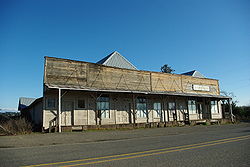 Location within the state of Oregon
 Mountaindale, Oregon
Coordinates: 45°37′29″N 123°02′20″W / 45.62472°N 123.03889°WCoordinates: 45°37′29″N 123°02′20″W / 45.62472°N 123.03889°W Country United States State Oregon County Washington Elevation 194 ft (59 m) Time zone Pacific (PST) (UTC-8) – Summer (DST) PDT (UTC-7) ZIP codes 97133 Area code(s) 503 and 971 FIPS code GNIS feature ID 1163167[1] Mountaindale is an unincorporated community in Washington County, Oregon, United States, about four miles northwest of North Plains.[2] Settled in the 1850s, the small community was the longtime home of the Mountaindale Store.
History
The Atfalati tribe of Native Americans had a seasonal campsite in the area prior to the arrival of European-Americans in the 1830s.[3] The first Euro-American settlers in the Mountaindale area were Samuel B. and Mary Raffety, who in 1852 traveled the Oregon Trail to the Oregon Territory and settled a donation land claim in northern Washington County in the foothills of the Oregon Coast Range.[4] Originally from Kentucky, they raised eight children on their 320-acre (130 ha) farm.[4] One child, Charles H. Raffety, later served as mayor of East Portland before its annexation into Portland.[4] Mountaindale School District 41 was formed on December 5, 1868, with Alzada Cornelius as the first teacher and W. D. Pittenger as the first superintendent.[4] The school was built at that time and was located on the Dobbins land claim.[5] The store was later built in front of the school.[5] The post office was established in 1873 as "Mountain Dale" and the name was changed to "Mountaindale" in 1895.[6][7] The name combining "mountain" and "dale" is descriptive, as the community is where East Fork Dairy Creek emerges from the foothills at the north edge of the Tualatin Valley.[6]
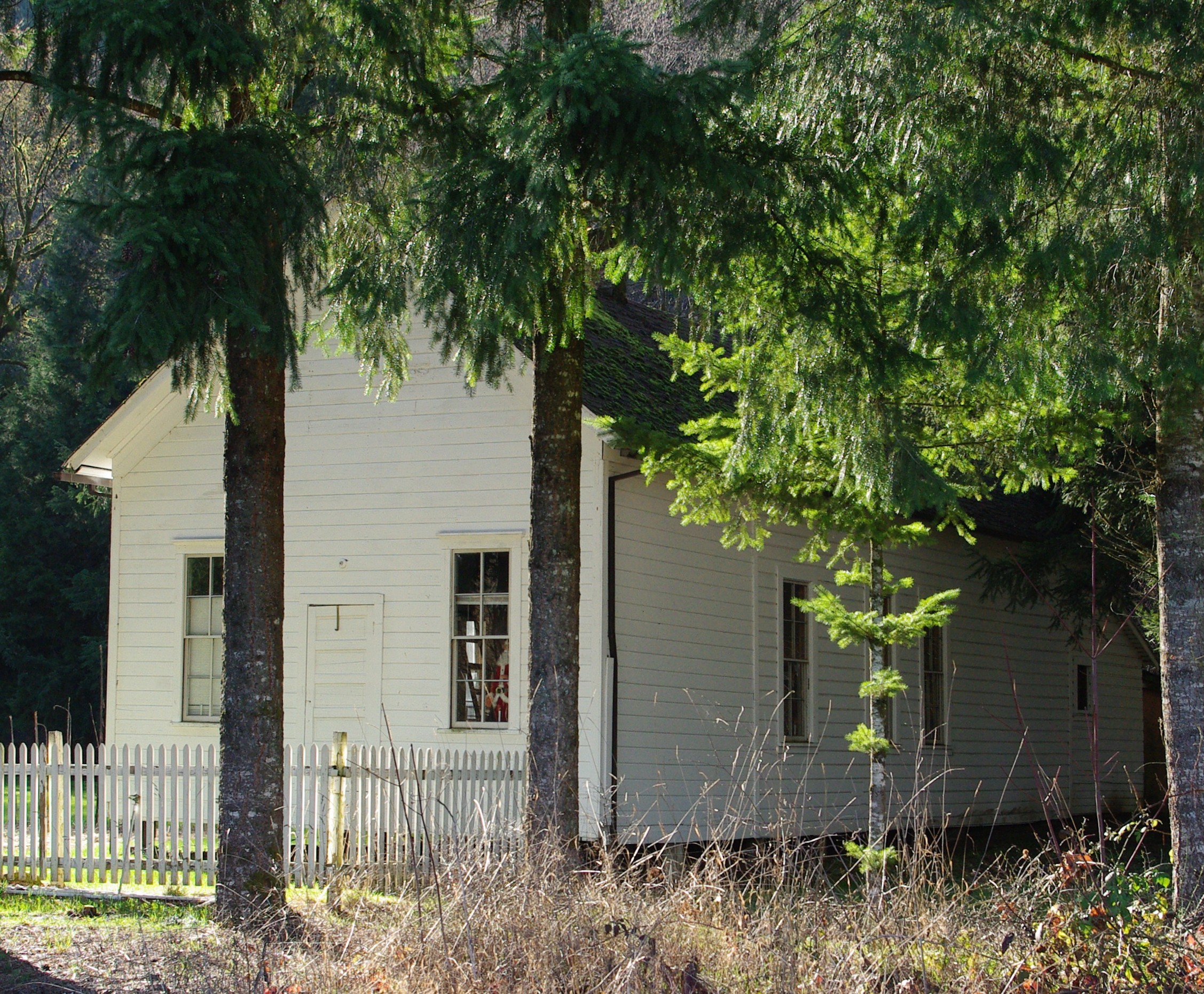
 Former school in 2010
In 1885,[8] a new schoolhouse was built for $200.[4] It was 30 feet (9.1 m) long, 13 feet (4.0 m) wide, and 12 feet (3.7 m) tall.[4] The new school was originally known as the Raffety School as it was built on land donated by Samuel Raffety.[5] Charles Reynolds opened the first store in the community in 1896.[4] In 1904, a new Mountaindale Store was built across the street from the original.[4] Reynolds also operated a freight line and a blacksmith shop.[4] In 1915, Mountaindale had two sawmills,[8] and much of the area surrounding area was logged.[3]
The Mountaindale post office closed in 1935.[6] In February 1953, the school district was merged into the North Plains School District (originally known as the Glencoe district), which merged into the Hillsboro School District in 1996.[5][9] The Mountaindale school remained in use until 1954 or 1955, and by 1976 was owned by the Stohr family.[5][8]
In 1990, the only public buildings remaining in the community were the store and the closed schoolhouse.[8] The store is also now closed.
The Mountaindale Airport is a mile southwest of the community.
References
- ^ "Mountaindale, Oregon". Geographic Names Information System, U.S. Geological Survey. http://geonames.usgs.gov/pls/gnispublic/f?p=gnispq:3:::NO::P3_FID:1163167.
- ^ "Mountaindale". Geographic Names Information System, U.S. Geological Survey. November 28, 1980. http://geonames.usgs.gov/pls/gnispublic/f?p=gnispq:3:::NO::P3_FID:1163167. Retrieved 2010-01-26.
- ^ a b Buan, Carolyn M. This Far-Off Sunset Land: A Pictorial History of Washington County, Oregon. Donning Company Publishers, 1999. p. 18, 38.
- ^ a b c d e f g h i "Communities: Mountaindale early history retraced to 1852 land grant". Hillsboro Argus: p. 5. October 19, 1976.
- ^ a b c d e Philpott, Betty (October 19, 1976). "Schools and Churches: Interest in history spurs preservation of school". Hillsboro Argus: pp. 9.
- ^ a b c McArthur, Lewis A.; McArthur, Lewis L. (2003) [First published 1928]. Oregon Geographic Names (7th ed.). Portland, Oregon: Oregon Historical Society Press. p. 680. ISBN 9780875952772. OCLC 53075956.
- ^ Benson, Robert L. (October 19, 1976). "Business and Industry: Post offices, zip codes listed". Hillsboro Argus: p. 11.
- ^ a b c d Friedman, Ralph (1990). In Search of Western Oregon (2nd ed.). Caldwell, Idaho: The Caxton Printers, Ltd. p. 150. ISBN 0-87004-332-3. http://books.google.com/books?id=4i1grNoMcWgC&printsec=frontcover&dq=In+Search+of+Western+Oregon&cd=1#v=onepage&q=&f=false.
- ^ Benson, Robert L. (October 19, 1976). "Historic Potpourri: Courthouse fire destroys school records in '20s". Hillsboro Argus: p. 10.
External links
 Media related to Mountaindale, Oregon at Wikimedia Commons
- Historic image of general store in Mountaindale from Salem Public Library
Municipalities and communities of Washington County, Oregon Cities Banks | Beaverton | Cornelius | Durham | Forest Grove | Gaston | Hillsboro | King City | Lake Oswego‡ | North Plains | Portland‡ | Rivergrove‡ | Sherwood | Tigard | Tualatin‡ | Wilsonville‡
CDPs Aloha | Bethany | Bull Mountain | Cedar Hills | Cedar Mill | Garden Home-Whitford | Metzger | Oak Hills | Raleigh Hills | Rockcreek | West Haven-Sylvan | West Slope
Unincorporated
communitiesBlooming | Bonny Slope | Buxton | Carnation | Cherry Grove | Dilley | Farmington | Gales Creek | Glenwood | Hayward | Helvetia | Kansas City | Kinton | Laurel | Laurelwood | Manning | Marlene Village | Middleton | Midway | Mountaindale | Mulloy | Norwood | Roy | Scholls | Timber | Tonquin | Verboort | West Union | Wilkesboro
Ghost towns Dixie | Greenville | Thatcher
Footnotes ‡This populated place also has portions in an adjacent county or counties
Categories:- Unincorporated communities in Washington County, Oregon


Wikimedia Foundation. 2010.