- Fanno Creek
Geobox | River
name = Fanno Creek
category = Creek
image_size = 300
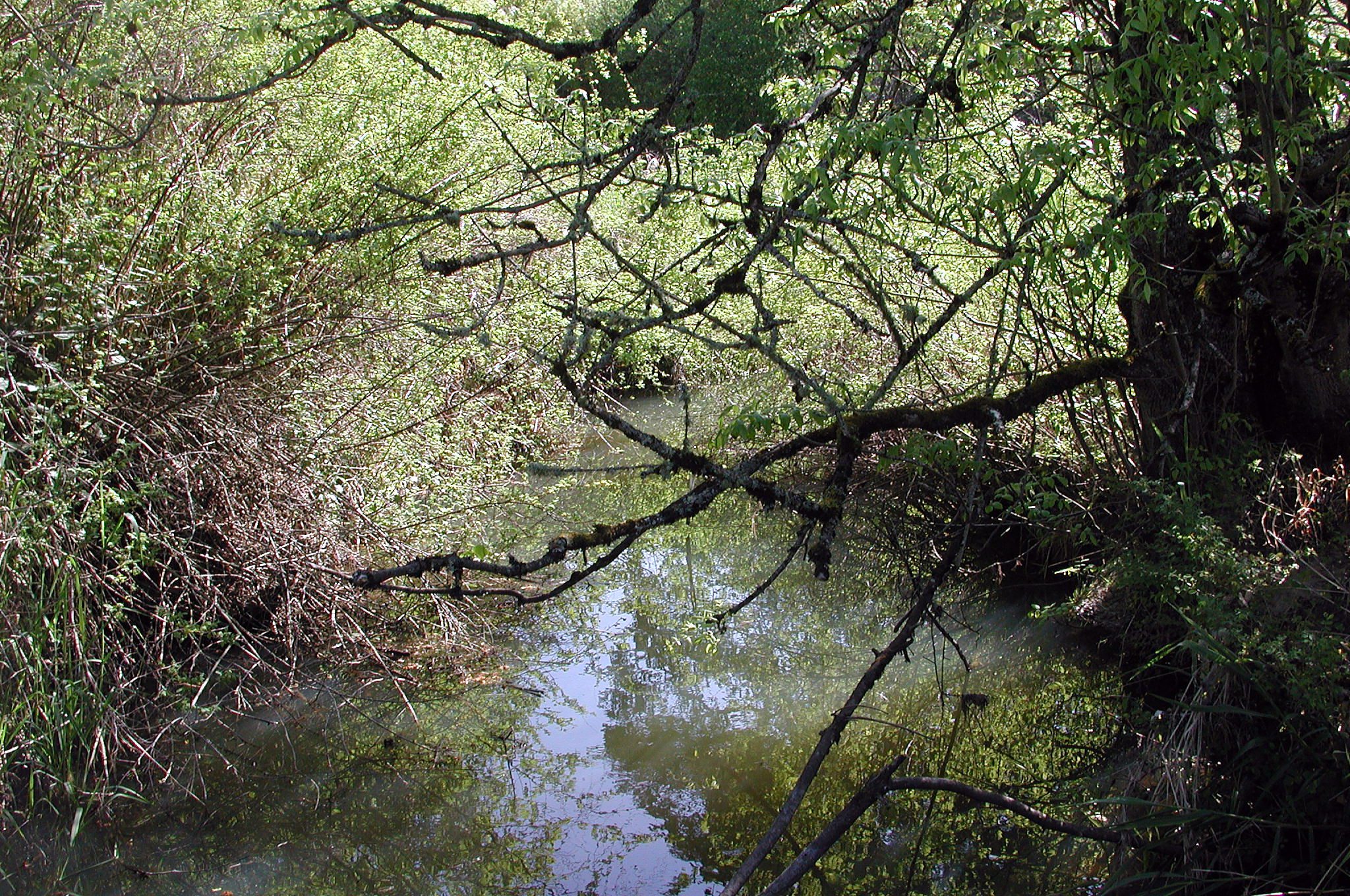
image_caption = Fanno Creek in Greenway Park, Beaverton
etymology = Augustus Fanno, early settler
country = United States
country_
state = Oregon
district_type = County
district = Multnomah and Washington
source =Tualatin Mountains (West Hills)
source_location = Portland
source_region = Multnomah County
source_state =Oregon
source_elevation_imperial = 478
source_elevation_note = Source elevation derived fromGoogle Earth search using GNIS source coordinates.]
source_length_imperial =
source_lat_d = 45
source_lat_m = 28
source_lat_s = 44
source_lat_NS = N
source_long_d = 122
source_long_m = 42
source_long_s = 00
source_long_EW = W
source_coordinates_note =
mouth_name =Tualatin River
mouth_location = Durham
mouth_district =
mouth_region = Washington County
mouth_state =Oregon
mouth_country =
mouth_note =
mouth_lat_d = 45
mouth_lat_m = 23
mouth_lat_s = 35
mouth_lat_NS = N
mouth_long_d = 122
mouth_long_m = 45
mouth_long_s = 50
mouth_long_EW = W
mouth_coordinates_note = cite web | work = Geographic Names Information System| publisher = United States Geological Survey | date = November 28, 1980 | url = http://geonames.usgs.gov/pls/gnispublic/f?p=gnispq:3:::NO::P3_FID:1120623| title = Fanno Creek | accessdaymonth = May 5, | accessyear = 2008]
mouth_elevation_imperial = 108
mouth_elevation_note =
length_imperial = 15
length_round = 0
length_note = cite web
title = Fanno Creek Watershed | publisher = Bureau of Environmental Services, City of Portland | date = 2008 | url = http://www.portlandonline.com/BES/index.cfm?c=dcbjj | accessdaymonth = May 5, | accessyear = 2008]
watershed_imperial = 31.7
watershed_round = 1
watershed_note =
discharge_location = Durham, convert|1.13|mi|km|2 from mouth
discharge_imperial = 46
discharge_round = 2
discharge_note = cite web| title=USGS Surface-Water Annual Statistics for the Nation: USGS 14206950 Fanno Creek at Durham, OR| publisher = United States Geological Survey |date = 2008 | url = http://waterdata.usgs.gov/usa/nwis/uv?site_no=14206950 | accessdaymonth = May 5, | accessyear = 2008 ] Average discharge rate was calculated by adding average annual discharge rates for the eight calendar years for which data was available from the USGS and dividing by 8.]
discharge_max_imperial = 1090
discharge_min_imperial = 1
discharge1_location =
discharge1_note =
map_size = 300
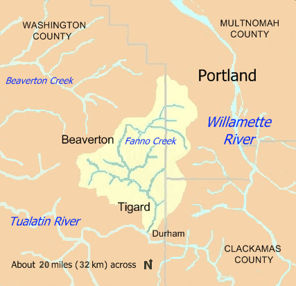
map_caption = Fanno Creek watershed
map1 = Oregon Locator Map.png
map1_caption = Location of the mouth of Fanno Creek in Oregon
map1_locator = Oregon
commons =Fanno Creek is a convert|15|mi|km|adj=on tributary of the
Tualatin River in the U.S. state ofOregon .cite web | title = Fanno Creek Watershed | publisher = Bureau of Environmental Services, City of Portland | date = 2008 | url = http://www.portlandonline.com/BES/index.cfm?c=dcbjj | accessdate = 2008-05-05] Part of the drainage basin of theColumbia River , its watershed covers about convert|32|sqmi|km2 in Multnomah, Washington, and Clackamas counties, including about convert|7|sqmi|km2 within the Portland city limits.From its headwaters in the
Tualatin Mountains (West Hills) in southwest Portland, the creek flows generally west and south through the cities of Portland, Beaverton, Tigard and Durham, andunincorporated area s of Washington County. It enters the Tualatin River about convert|9|mi|km|0 above the Tualatin's confluence with theWillamette River at West Linn.For thousands of years, the Atfalati (Tualatin) tribe of the
Kalapuya inhabited the watershed. The first settler of European descent, Augustus Fanno, for whom the creek is named, arrived in the mid-19th century. He established an onion farm in what became Beaverton. Fanno Farmhouse, the restored family home, is aCentury Farm on theNational Register of Historic Places and is one of 14 urban parks in a narrow corridor along the creek.Although heavily polluted, the creek supports aquatic life, including
cutthroat trout in its upper reaches. Watershed councils such as the Friends of Fanno Creek and government agencies have worked to limit pollution and to restore native vegetation inriparian zones.Course
Fanno Creek arises at an elevation of convert|478|ft|m above
sea level and falls convert|370|ft|m between source and mouth to an elevation of convert|108|ft|m. The main stem begins at aboutriver mile (RM) 15 or river kilometer (RK) 24 in the Hillsdale neighborhood of southwest Portland, in Multnomah County. The creek flows west along the north side ofOregon Route 10 (the Beaverton–Hillsdale Highway), passing Albert Kelly Park and receiving Ivey Creek and Bridlemile Creek on the right before reaching theUnited States Geological Survey (USGS) stream gauge at Southwest 56th Avenue convert|11.9|mi|km from the mouth. Shortly thereafter and in quick succession, it enters Washington County and the unincorporated community of Raleigh Hills, crosses under Route 10, and receives Sylvan Creek on the right. Here the stream turns south, passing through Bauman Park, where Vermont Creek enters on the left about convert|10|mi|km from the mouth, and then southwest to flow through the Portland Golf Club and Vista Brook Park, where Woods Creek enters on the left. From here it flows west again for about convert|1|mi|km, passing through Fanno Creek Trail Park and entering Beaverton about convert|8|mi|km from the mouth before turning sharply south and flowing underOregon Route 217 (Beaverton–Tigard Highway).Fanno Creek then flows roughly parallel to Route 217 for about convert|2|mi|km|0 through Fanno Creek Park and Greenway Park. Near the southern end of Greenway Park, the creek passes under
Oregon Route 210 (Scholls Ferry Road), and enters Tigard about convert|5|mi|km|0 from the mouth. In quick succession, Hiteon Creek enters on the right, Ash Creek on the left, and Summer Creek on the right before the creek reaches Woodard Park, goes underOregon Route 99W (Southwest Pacific Highway), and flows through Fanno Park and Bonita Park as well as residential neighborhoods. Between the two parks, Red Rock Creek enters on the left about convert|2.5|mi|km from the mouth. Slightly downstream of Bonita Park, Ball Creek enters on the left. Fanno Creek then enters Durham, passes a USGS gauging station convert|1.13|mi|km from the mouth, flows through Durham City Park, and empties into the Tualatin River convert|9.3|mi|km| from its confluence with the Willamette nowrap|River.cite map |publisher = G.M. Johnson and Associates |title = City Streetedition = 2007 |isbn=9781897152942] cite map | publisher = Rand McNally | title = Streets of Portland | edition = 2006 |isbn = 0-528-86776-8] cite map |publisher = DeLorme Mapping |title = Oregon Atlas & Gazetteer |edition = 1991
section = 60–61 |isbn = 0-89933-235-8] cite web | title = Tour of the Watershed | publisher = Tualatin Riverkeepers | date = 2006 | url = http://www.tualatinriverkeepers.org/text/map.pdf | format = pdf | accessdaymonth = May 23, | accessyear = 2008]Discharge
The USGS monitors the flow of Fanno Creek at two stations, one in Durham, convert|1.13|mi|km from the mouth and the other in Portland, convert|11.9|mi|km from the mouth. The average flow of the creek at the Durham station is convert|46|cuft/s|m3/s. This is from a drainage area of convert|31.5|sqmi|km2|1, more than 99 percent of the total Fanno Creek watershed. The maximum flow recorded there was convert|1090|cuft/s|m3/s on February 6, 1996, and the minimum flow was convert|1|cuft/s|m3/s|2 on September 13, 2001. Note: The average discharge rate for this location was calculated by adding the average annual discharge rates for the eight calendar years for which data was available and dividing by 8. cite web| title=USGS Surface-Water Annual Statistics for the Nation: USGS 14206950 Fanno Creek at Durham, OR| publisher = United States Geological Survey |date = 2008 | url = http://waterdata.usgs.gov/usa/nwis/uv?site_no=14206950 | accessdate = 2008-05-05 ] At the Portland station, the average flow is convert|3.26|cuft/s|m3/s|2. This is from a drainage area of convert|2.37|sqmi|km2 or about 7 percent of the total Fanno Creek watershed. The maximum flow recorded there was convert|733|cuft/s|m3/s|0 on February 8, 1996, and the minimum flow was convert|0.01|cuft/s|m3/s|4 on September 4, 2001.cite web | title = 14206900 Fanno Creek at 56th Avenue
publisher = United States Geological Survey | date = 2008 | url = http://waterdata.usgs.gov/or/nwis/uv/?site_no=14206900 | accessdaymonth = May 8, | accessyear = 2008] [The average discharge rate for this location was calculated by adding the average annual discharge rates for the 16 calendar years for which data was available and dividing by 16.]Watershed
, near the headwaters of Ball Creek, a Fanno Creek tributary. [Tualatin Riverkeepers, p. 105]
The slopes at the headwaters of Fanno Creek consist mainly of Columbia River Basalt exposed in ravines but otherwise covered by up to convert|25|ft|m|0 of wind-deposited silt. Silts and clays are the most common watershed soils, and significant
erosion is common.cite web | last = Alta Planning + Design | title = Fanno Creek Greenway Trail Action Plan | publisher = Metro | date = 2003 | url = http://www.metro-region.org/files/planning/fannocreekplan.pdf | format = pdf | accessdaymonth = May 13, | accessyear = 2008] About convert|50|in|mm of precipitation, almost all of which is rain and about half of which arrives in November, December, and January, falls on the watershed each year. Although significant flooding occurred in 1977, the watershed has not experienced a100-year flood since the area became urban.Small watersheds adjacent to the Fanno Creek watershed include those of minor tributaries of the Willamette or Tualatin rivers.
Tryon Creek ,Balch Creek , and other small streams east of Fanno Creek flow down the eastern flank of the West Hills into the Willamette. To the northwest, Hall Creek, Cedar Mill Creek, and Bronson Creek flow into Beaverton Creek, a tributary of Rock Creek, which empties into the Tualatin River at the larger stream's RM 38.4 (RK 61.8), about convert|29|mi|km| upriver from the mouth of Fanno Creek.cite map | publisher = Rand McNally | title = Local: Beaverton/Hillsboro, McMinnville/Newberg | edition = 2003 | isbn=0-528-99834-X ]History
reservation further west. [Tualatin Riverkeepers, pp. 21–23] Fanno Creek is named after Augustus Fanno, the first European American settler along the creek. In 1847, he started an onion farm on a convert|640|acre|ha|adj=on donation land claim in what later became part of Beaverton. Other 19th century newcomers along the creek engaged mainly in logging, farming, and dairy farming until the
Southern Pacific Railroad and theOregon Electric Railway lines made the watershed more accessible for urban development around the turn of the century. The Oregon Electric, a convert|49|mi|km|adj=on system built between 1903 and 1915, ran between downtown Portland and Garden Home in the Fanno Creek watershed, where it split into branches leading to Salem and Forest Grove. The Southern Pacific began running electric trains, known as the Red Electric, in the watershed in 1912. The company that eventually becamePortland General Electric installed electric service in the area, and by 1915 the population of the upper Fanno Creek neighborhoods of Multnomah, Maplewood, Hillsdale, and West Portland Park had grown to 2,000.cite web | last = Alta Planning + Design | title = Fanno Creek Greenway Trail Action Plan | publisher = Metro | date = 2003 | url = http://www.metro-region.org/files/planning/fannocreekplan.pdf | format = pdf | accessdaymonth = May 13, | accessyear = 2008].
The highways and railroads serve a population that increased most dramatically in the second half of the 20th century. When Beaverton became a city in 1893, it had a population of 400. [cite web | title = Beaverton History | publisher = City of Beaverton | date = 2007 | url = http://www.beavertonoregon.gov/community/history.aspx | accessdaymonth = August 15, | accessyear = 2008] In 1960, it still had only 6,000 residents, but the number soared to 76,000 by the year 2000, although not all of them lived in the watershed. [cite web | title = Beaverton Demographic Profiles | publisher = City of Beaverton | date = 2007 | url = http://www.beavertonoregon.gov/community/Census2000/population_housing.aspx | accessdaymonth = August 15, | accessyear = 2008] Tigard, which did not exist as a city until 1961, [cite web | title = Oregon Bluebook: Tigard | publisher = Oregon State Archives | date = 2008 | url = http://bluebook.state.or.us/local/cities/sy/tigard.htm| accessdaymonth = August 15, | accessyear = 2008] grew to 41,000 by the year 2000, [cite web | title = Population Finder | publisher = U.S. Census Bureau | date = 2008 | url = http://factfinder.census.gov/servlet/SAFFPopulation?_event=Search&geo_id=01000US&_geoContext=01000US&_street=&_county=tigard&_cityTown=tigard&_state=04000US41&_zip=&_lang=en&_sse=on&ActiveGeoDiv=geoSelect&_useEV=&pctxt=fph&pgsl=010&_submenuId=population_0&ds_name=null&_ci_nbr=null&qr_name=null®=null%3Anull&_keyword=&_industry=| accessdaymonth = August 15, | accessyear = 2008] all in the watershed. The estimated population of the entire watershed reached 123,000 just before the 2000 census. [cite web | last = Inforain: Maps That Matter | title = Fanno Creek | work = Tualatin River Watershed Information System | publisher = Ecotrust | date =1998 | url = http://www.inforain.org/watershed/index.php?full_address=tigard | accessdaymonth = May 7, | accessyear = 2008] Fanno Creek, which had few people living near it until 1850, "is surrounded by the most populous region in Oregon".cite web
last = Swan | first = Darryl | title = Reversing toxic toll on Fanno Creek | work = Portland Tribune
publisher = Pamplin Media Group | date = July 17, 2008 | url = http://www.portlandtribune.com/sustainable/story.php?story_id=121607464559381500 | accessdaymonth = August 15, | accessyear = 2008 ]Pollution
Although the Oregon Department of Environmental Quality (DEQ) rated the average water quality of Fanno Creek as "very poor" between 1986 and 1995, it also noted steady improvement over that span. Historically, Fanno Creek has been polluted by urban and industrial sources, small sewage treatment plants, ineffective septic systems, farming and grazing operations, and illegal dumping. Health and environmental concerns led to the closing of substandard wastewater treatment plants in the 1970s, and urban development reduced the number of farms and farm animals along the creek. A ban in 1991 on
phosphate detergents, increased connection to municipal sewers, stormwater management, and greater public awareness helped to reduce urban pollution not coming from point sources, and water quality improved.DEQ monitors Fanno Creek at Bonita Road in Tigard, at about convert|2|mi|km from the mouth. On the Oregon Water Quality Index (OWQI) used by DEQ, water quality scores can vary from 10 (worst) to 100 (ideal). The average for Fanno Creek between 1986 and 1995 was 55 but steadily improved to 65, or "poor", by the end of the period. By comparison, the average in the nearby Willamette River at the Hawthorne Bridge in downtown Portland was 74 during the same years.cite web | last = Wade | first = Curtis | title = Tualatin Subbasin | work = Oregon Water Quality Index Report for Lower Willamette, Sandy, and Lower Columbia Basins: Water Years 1986-1995 | publisher = Oregon Department of Environmental Quality | url = http://www.deq.state.or.us/lab/wqm/wqindex/lowillsandy.htm | accessdaymonth = May 17, | accessyear = 2008 ] Measurements of water quality at the Tigard site during the years covered by the DEQ report showed high concentrations of phosphates, fecal coliform bacteria, and suspended solids, and a high
biochemical oxygen demand . Moderately high concentrations ofammonia andnitrate nitrogen occurred during high flows during fall, winter, and spring. High temperatures and low dissolved oxygen concentration in the summer were evidence ofeutrophication .The high fraction of
impervious surface s in the watershed makes it difficult to improve water quality in the creek. The Portland Bureau of Environmental Services estimates that one-third of the surface area of the watershed that lies within its jurisdiction is impervious.cite web | title = About the Watershed | publisher = Portland Bureau of Environmental Services, City of Portland | date = 2008 | url = http://www.portlandonline.com/BES/index.cfm?c=33005& | accessdaymonth=September 11, | accessyear = 2008 ] All of the roughly convert|12|sqmi|km2 of the surface of Tigard, much of it impervious, drains into Fanno Creek. The watershed watch coordinator for Tualatin Riverkeepers, a volunteer group, was quoted in a July 2008 newspaper article saying that "the biggest impact to Fanno Creek is the impervious area”. To slow run-off, reduce erosion, and keep pollutants out of streams, watershed councils, neighborhood groups, and government agencies have been planting native species of vegetation at selected sites throughout the watershed.Biology
Fish and wildlife
About 100 bird species, several kinds of mammals, and a few fish species live in the watershed. Mammals commonly seen include
beaver ,raccoon ,opossum , spottedskunk , Douglas squirrel, and Townsend'schipmunk ; black-tail deer andcoyote s are more rare. Fanno Creek supports non-migratingcutthroat trout that spawn in the fast-flowing, gravel-bottomed headwaters and grow to a maximum length of about convert|7|in|cm. Other fish species found in the creek includesculpin s,dace , andmosquitofish .Vegetation
. [cite web
last = Thorson | first = T.D. | coauthors = Bryce, S.A.; Lammers, D.A., "et al." | title = Ecoregions of Oregon (front side of color poster with map, descriptive text, summary tables, and photographs) | publisher = United States Geological Survey | date = 2003 | url = ftp://ftp.epa.gov/wed/ecoregions/or/or_front.pdf | format = pdf | accessdaymonth = June 19, | accessyear = 2008 Reverse side [ftp://ftp.epa.gov/wed/ecoregions/or/or_back.pdf here] ] The narrowriparian corridors along streams in the watershed commonly include native species such as western redcedar,Douglas-fir , vine maple, and sword fern as well as invasive species like English ivy. Manyred alder and big leaf maple grow in the watershed, and shrubs include red huckleberry,Oregon-grape , elderberry, wood rose, and salmonberry. A restoration project in Tigard along the main stem has removed invasive plants such asreed canary grass and Himalayan blackberry and replaced them with native species. [cite web | title = Grant Received for Fanno Creek Park Enhancement Plan | publisher = City of Tigard | date = 2003 | url = http://www.ci.tigard.or.us/news/03-06-17_fanno_creek_grant.asp | accessdaymonth = May 19 | accessyear = 2008] A project in Beaverton replaced turf and rough-mowed grass near the creek with native shrubs and trees such as Oregon white oak. [cite web | title = Greenway Habitat Enhancement Plan | publisher = Tualatin Hills Park & Recreation District | date = 2007 | format= pdf | url = http://www.thprd.org/pdfs/facilities/GWoutreachinfo.pdf | accessdaymonth = May 19, | accessyear = 2008]The Tualatin Riverkeepers, a nonprofit watershed council based in Tigard; Clean Water Services, a public utility that protects water resources in the Tualatin River watershed, and the Tualatin Hills Park and Recreation District (THPRD) have formed the Tualatin Basin Invasive Species Working Group to identify and eradicate invasive plants that displace native plants, cause erosion, and diminish water quality. The five plants considered most threatening are
Japanese knotweed , meadow knapweed, giant hogweed, garlic mustard and purple loosestrife. The Oregon Department of Agriculture and the city of Tigard are working to eradicate giant hogweed from lower Fanno Creek. [cite web | title = Tualatin Watershed Weed Watch | publisher = Tualatin Riverkeepers | url = http://www.tualatinriverkeepers.org/weedwatch.html | accessdaymonth = May 19, | accessyear = 2008]Parks
north of the creek about convert|14|mi|km from the mouth, [cite web | last = Portland Parks and Recreation Department | title = Albert Kelly Park | publisher = City of Portland | date = 2008 | url = http://www.portlandonline.com/parks/finder/index.cfm?PropertyID=48&action=ViewPark | accessdaymonth = May 9, | accessyear = 2008] and the Fanno Creek Natural Area, convert|7|acre|ha north of the creek about convert|12|mi|km from the mouth. [cite web | last = Portland Parks and Recreation Department | title = Fanno Creek Natural Area | publisher = City of Portland | date = 2008 | url = http://www.portlandonline.com/parks/finder/index.cfm?ShowResults=yes&SearchText=fanno+creek | accessdaymonth = May 5, | accessyear = 2008]
THPRD manages seven Fanno Creek parks in Beaverton and unincorporated Washington County. The district, tax-supported and governed by an elected board, is the largest special park and recreation district in Oregon. [cite web | title = Administration | publisher = Tualatin Hills Park and Recreation District | date = 2008 | url = http://www.thprd.org/administration/index.cfm | accessdaymonth = May 11, | accessyear = 2008] The seven include Bauman Park, about convert|8|acre|ha at about convert|10|mi|km from the mouth. Slightly downstream from Bauman Park are Vista Brook Park, about convert|4|acre|ha with trails including one that is accessible to people with physical handicaps, a playground, and courts for basketball and tennis, and Fanno Creek Trail, about convert|2|acre|ha|1, with picnic tables and trails. Other THPRD parks lie along Fanno Creek from roughly convert|7|mi|km to roughly convert|5|mi|km|0 from the mouth. These are Fanno Creek Park, about convert|21|acre|ha, with trails including one accessible to people with handicaps; Fanno Farmhouse, about convert|1|acre|ha|1 with an accessible trail and picnic tables as well as the Fanno family home, restored by THPRD and listed on the
National Register of Historic Places ; Greenway Park, about convert|87|acre|ha with trails including an accessible trail, picnic tables, a playground, and sports fields, and Koll Center Wetlands, about convert|13|acre|ha with wildlife.cite web | title = Parks and Trails: Find a Park | publisher = Tualatin Hills Park and Recreation District | date = 2008 | url = http://www.thprd.org/parks/findpark.cfm?pl=y | accessdaymonth = May 11, | accessyear = 2008] [cite web | title = Oregon, Washington County: Fanno, Augustus, Farmhouse | publisher = National Register of Historic Places | url = http://www.nationalregisterofhistoricplaces.com/or/Washington/state.html | accessdaymonth = May 14, | accessyear = 2008]The three Fanno Creek parks managed by the city of Tigard include Woodard Park, convert|10|acre|ha of big trees, trails, and play structures; [ cite web | title = Woodard Park | publisher = City of Tigard | date = 2008 | url = http://www.ci.tigard.or.us/community/parks/woodard_park.asp | accessdaymonth = May 9, | accessyear = 2008] Bonita Park, with a playground and picnic areas, [ cite web | title = Bonita Park | publisher = City of Tigard | date = 2008 | url = http://www.ci.tigard.or.us/community/parks/bonita_park.asp | accessdaymonth = May 9, | accessyear = 2008] and Fanno Park, a natural area behind City Hall. [cite web | title = Fanno Park | publisher = City of Tigard | date = 2008 | url = http://www.ci.tigard.or.us/community/parks/fanno_creek_park.asp | accessdaymonth = May 5, | accessyear = 2008 ] About 20 percent of the small city of Durham is parkland. Surrounded by the larger cities of Tigard and Tualatin, the city covers convert|265|acre|ha occupied by about 1,400 people. Durham City Park, at the confluence of Fanno Creek and the Tualatin River, consists of convert|46|acre|ha of heavily-wooded
floodplain with paved trails, children's play areas, and a picnic shelter. [cite web | title = City of Durham, Oregon: Welcome | publisher = League of Oregon Cities | date = 2005 | url = http://www.durham-oregon.us/ | accessdaymonth = May 11, | accessyear = 2008 ]Sections of trail along the main stem of Fanno Creek form part of a planned convert|15|mi|km|adj=on Fanno Creek Greenway Trail linking Willamette Park on the Willamette River in southwest Portland to the confluence of the creek with the Tualatin River in Durham. The trail, for pedestrians and bicyclists, is accessible to people with disabilities. Many unfinished segments remained as of 2008. [cite web | title = Fanno Creek Greenway Trail | publisher = Metro | date = 2008 | url = http://www.metro-region.org/index.cfm/go/by.web/id=1045 | accessdaymonth = May 5, | accessyear = 2008 ]
See also
*
List of rivers of Oregon Works cited
Tualatin Riverkeepers (2002). "Exploring the Tualatin River Basin". Corvallis, Oregon: Oregon State University Press. ISBN 0-87071-540-2.
Notes and references
External links
* [http://www.fansoffannocreek.org/ Fans of Fanno Creek]
* [http://swni.org/bridlemile_neighborhood_association/creek_stewards Bridlemile Creek Stewards]
* [http://www.tualatinriverkeepers.org/about_us.html Tualatin Riverkeepers]
* [http://www.thprd.org/parks/parkmap.cfm Tualatin Hills Park District map]
* [http://www.cleanwaterservices.org/default.aspx Clean Water Services]
* [http://www.co.washington.or.us/deptmts/wtr_mstr/surfacewater/streammileindex.html#fanno Fanno Creek stream mile index]

Wikimedia Foundation. 2010.