- Oregon Route 8
-
For the unsigned Highway 8, see Oregon-Washington Highway.
Oregon Route 8
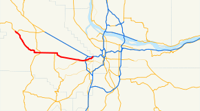
Route information Maintained by ODOT Length: 19.20 mi[citation needed] (30.90 km) Existed: 1957 – present Major junctions West end:  OR 47 in Forest Grove
 OR 219 in Hillsboro
 OR 217 in Beaverton
East end:  US 26 in Beaverton
Highway system Oregon highways
Routes • Highways←  OR 7
OR 7OR 10  →
→Oregon Route 8 is an Oregon state highway which serves the western suburbs of Portland. The road is locally known as Canyon Road and Tualatin Valley Highway, and travels through the center of the Tualatin Valley. Oregon 8 is located entirely within Washington County. The portion of the route from US 26 to Oregon Route 47 is part of the National Highway System, listed as a principal arterial.[1]
Contents
Route description
The eastern terminus of OR 8 is an interchange with U.S. Route 26 (which is, at that point, the Sunset Highway) just west of the Portland city limits and the Washington-Multnomah county line. Initially, it is also known as Canyon Road, since it comes out of the gulch in which the Sunset Highway runs. The official designation, beginning from the eastern terminus, is the Tualatin Valley Highway No. 29 (see Oregon highways and routes).[2]
Continuing west, OR 8 enters the suburb of Beaverton, and after its interchange with Oregon Route 217, a freeway, its posted name changes to the Tualatin Valley (TV) Highway at Hocken Avenue. It comes within one block of Oregon Route 10, running parallel but never intersecting, although commuters often use surface streets to change between the highways.
TV Highway continues west as an expressway out of Beaverton, through the communities of unincorporated urban Washington County, including Aloha, where it runs right next to one chipmaker Intel's facilities. The highway continues into the Hillsboro neighborhoods of Reedville and Witch Hazel, receiving the southern terminus of Cornelius Pass Road at Reedville. It then into the city proper of Hillsboro, running north–south as 10th Street before turning east–west with traffic split into a one-way pair. Westbound traffic runs as Baseline Street and eastbound traffic runs on Oak Street. In downtown Hillsboro it receives the northern terminus of Oregon Route 219, which is 1st Street.
After passing through downtown Hillsboro, OR 8 moves westward through the adjoined towns of Cornelius and Forest Grove, passing next to Pacific University. At Cornelius the road is again split into a one-way pair, with westbound traffic running on Adair Street, and eastbound on Baseline. In Forest Grove, it intersects with Oregon Route 47, where it becomes part of the Nehalem Highway No. 102. TV Highway continues as OR 47 south to McMinnville. In downtown Forest Grove the road splits again, with eastbound traffic running on 19th Street, and westbound on Pacific Avenue. West of Forest Grove, OR 8 is known as Gales Creek Road, which is not actually a state highway; after passing though some farmland west of Forest Grove, including the community of Gales Creek, OR 8 reaches its western terminus in an intersection with Oregon Route 6 south of the community of Glenwood.
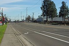 The highway in Beaverton near Murray Boulevard looking east
History
The section between Beaverton and Hillsboro was built about 1918.[3] Constructed of cement, it partly replaced a county road built of dirt that ran on the southern side of the railroad tracks.[3] The earlier road came from Portland via Bertha on Farmington Road and veered north on what is now Kinnaman Road until 209th Avenue in Reedville where it then ran parallel to the rail tracks.[3] At Witch Hazel it then followed the modern Witch Hazel and River roads into Hillsboro proper.[3]
In March 1919, Hillsboro elected to have the highway moved from Main Street two blocks south to Baseline Street (eastbound traffic was later moved to Oak Street).[4] Washington County planners in March 1953 decided to have the highway widened to four lanes.[4]
Major intersections
- Note: mileposts do not reflect actual mileage due to realignments.
County Location Mile[5] Destinations Notes Washington  OR 6 – Banks, Portland, Glenwood, Tillamook
Forest Grove 17.88 OR 47 – Banks, Seaside, Yamhill, McMinnvilleHillsboro 13.21 OR 219 – Scholls, Newberg8.32 Cornelius Pass Road Northbound only Beaverton 4.02 Hocken Avenue to Cedar Hills Boulevard/Farmington Road (OR 10) 3.60 Watson Avenue – Progress, Farmington Former OR 217 south 2.89 OR 217 / to Sunset Highway (US 26) – Cedar Hills, Tigard, SalemInterchange Multnomah 0.00 Sylvan Interchange; eastbound exit and westbound entrance 0.00 US 26 east – PortlandInterchange; eastbound exit and westbound entrance See also
References
- ^ Oregon Transportation Map: Washington County. Oregon Department of Transportation. Retrieved on December 20, 2009.
- ^ [1]
- ^ a b c d Jensen, Doris (October 17, 1976). "Communities: Reedville named for early resident". Hillsboro Argus: p. 17.
- ^ a b Alexander, Paul (October 19, 1976). "Transportation: Highways, roads played vital role". Hillsboro Argus: p. 5.
- ^ Oregon Department of Transportation, Public Road Inventory (primarily the Digital Video Log), accessed April 2008
Categories:- State routes in Oregon
- Transportation in Hillsboro, Oregon
- Transportation in Washington County, Oregon
- Transportation in Multnomah County, Oregon


Wikimedia Foundation. 2010.