- Tualatin Valley Highway
-
Tualatin Valley Highway 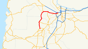
Highway system The Tualatin Valley Highway No. 29 (see Oregon highways and routes) is an Oregon highway which passes through the Tualatin Valley, between the cities of McMinnville and Beaverton. Between McMinnville and Forest Grove, the highway is signed as Oregon Route 47; between Forest Grove and Beaverton it is signed as Oregon Route 8.
The highway is commonly referred to as the TV Highway by locals.[1] TriMet bus route 57-TV Hwy. provides public transit service over the full length of the section between Forest Grove and Beaverton.[2]
History
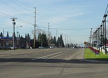 Highway in Beaverton near change to Canyon Road
About 1918, a highway constructed of cement was built between Beaverton and Hillsboro.[3] The highway replaced a dirt road maintained by the county that ran on the southern side of the railroad tracks.[3] This earlier road came from Portland along Farmington Road and veered north on what is now Kinnaman Road in Aloha until 209th Avenue in Reedville where it ran parallel to the rail tracks.[3] Further west at Witch Hazel the early road then followed the modern Witch Hazel and River Roads into Hillsboro proper.[3] Hillsboro decided in March 1919 to have the new road travel along Baseline Street, two blocks south of Main Street where the road was to run.[4] In March 1953, Washington County planners decided to have the highway widened to four lanes from Beaverton to Forest Grove.[4]
References
- ^ KATU
- ^ Bus Line 57-TV Hwy/Forest Grove schedule and map. TriMet. Retrieved 2010-06-17.
- ^ a b c d Jensen, Doris (October 17, 1976). "Communities: Reedville named for early resident". Hillsboro Argus: p. 17.
- ^ a b Alexander, Paul (October 19, 1976). "Transportation: Highways, roads played vital role". Hillsboro Argus: p. 5.
Categories:- Western United States road stubs
- Named state highways in Oregon
- Transportation in Hillsboro, Oregon
- Transportation in Washington County, Oregon
- Transportation in Yamhill County, Oregon
- Forest Grove, Oregon


Wikimedia Foundation. 2010.