- Opal Creek Wilderness
-
Opal Creek Wilderness 
Old growth in Opal Creek WildernessLocation Marion County, Oregon, USA Nearest city Detroit, Oregon Coordinates 44°50′48.14″N 122°12′32.79″W / 44.8467056°N 122.2091083°WCoordinates: 44°50′48.14″N 122°12′32.79″W / 44.8467056°N 122.2091083°W Area 20,266 acres (8,201 ha) Established September 30, 1996 Governing body United States Forest Service The Opal Creek Wilderness is a wilderness area located in the Willamette National Forest in the U.S. state of Oregon, on the border of the Mount Hood National Forest. It has the largest uncut watershed in Oregon.[1]
Opal Creek and nearby Opal Lake were named for Opal Elliot, wife of early US Forest Service ranger Roy Elliot.[2]
Contents
Geography
The 20,266-acre (8,201 ha) Opal Creek Wilderness is adjacent to a designated "scenic recreation area" of 13,000 acres (5,300 ha), creating a nearly 34,000-acre (14,000 ha) protected area. In addition, the 27,427-acre (11,099 ha) Bull of the Woods Wilderness in Mount Hood National Forest shares its southern boundary with the Opal Creek Wilderness.[3][4]
History
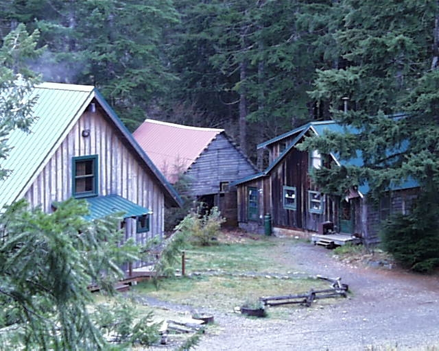
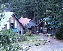 Cabins of former mining community of Jawbone Flats, now used by the Opal Creek Ancient Forest Center
The wilderness was designated September 30, 1996 after a nearly twenty year battle to protect the area from logging and mining. In 1980, the District Ranger of the Detroit Ranger District, Dave Alexander, vowed to "cut Opal Creek." By late 1981, clearcut boundary markers were placed. Lawsuits were filed, scenic rivers were designated, and multiple bills to protect the area failed, including an attempt to make it a state park. When books and photo essays were published in the early 1990s, national attention was brought to the area.[5] Finally, in 1996, after working with all stakeholders, including environmental groups, local communities and representatives of the timber industry, to draft consensus legislation, United States Senator Mark Hatfield obtained passage of expansive legislation to protect Opal Creek.[6] Mark O. Hatfield remarks. With the input of a federal advisory committee, the area has been managed and preserved by the U.S. Forest Service pursuant to the Opal Creek legislation.[1]
Natural history
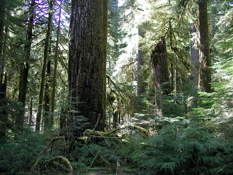
The Opal Creek Valley contains 50 waterfalls, five lakes, and 36 miles of hiking trails. It forms the largest intact stand of Old growth forest in the western Cascades and 500-1000 year old trees are common. The most abundant trees are Douglas-fir, Western Redcedar, and Western Hemlock.[4] Common hardwoods include big leaf maple and red alder. Understory vegetation includes huckleberry, vine maple and rhododendron.[7] There are eight trails in Opal Creek, totaling 36 miles. These are remnants of the early day prospecting and fire access routes.[7]
Gallery
-

A very old and tall old-growth tree in Opal Creek Wilderness
-

Old-growth forest in Opal Creek Wilderness
-

A native white fawn lily growing in Opal Creek Wilderness
-
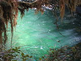
Opal pool along Opal Creek
References
- ^ "Opal Creek Wilderness". The Cranberry House. http://cranberryhouse.biz/Cranberry%20Web%20070502/Opal%20Creek%20Wilderness.html. Retrieved 2007-08-20.
- ^ McArthur, Lewis A.; Lewis L. McArthur (2003) [1928]. Oregon Geographic Names (Seventh Edition ed.). Portland, Oregon: Oregon Historical Society Press. ISBN 0-87595-277-1 (trade paperback), ISBN 0-87595-278-X (hardcover).
- ^ "Willamette National Forest—Opal Creek Wilderness and Scenic Area Trail Area". United States Forest Service. http://www.fs.fed.us/r6/willamette/recreation/tripplanning/trails/opalcreekwilderness/index.html. Retrieved 2007-08-20.
- ^ a b "Willamette National Forest—Opal Creek Wilderness". United States Forest Service. http://www.fs.fed.us/r6/willamette/recreation/tripplanning/wilderness/opalcreek.html. Retrieved 2007-08-20.
- ^ David Seideman (June 1993). Showdown at Opal Creek: The Battle for America's Last Wilderness. Carroll & Graf. ISBN 978-0881848670. http://www.amazon.com/Showdown-Opal-Creek-Americas-Wilderness/dp/0881848670.
- ^ Michael Donnelly (Spring 1997). "Opal Creek Preserved". Alternatives. Get Real Inc.. http://www.alternativesmagazine.com/01/donnelly.html. Retrieved 2007-08-20.
- ^ a b Willamette National Forest - Opal Creek Wilderness
See also
External links
- Opal Creek Ancient Forest Center
- Willamette National Forest - Opal Creek Wilderness
- Forests and Global Warming - Oregon Wild
- Photos of Opal Creek corridor (commercial photography website)
Protected Areas of Oregon Federal State Arcadia Beach • Bob Straub • Bradley • Cape Kiwanda • Cape Lookout • Cape Meares • Clay Myers at Whalen Island • Del Rey Beach • Ecola • Elmer Feldenheimer • Fishing Rock • Fort Stevens • Gearhart Ocean • Haystack Hill • Hug Point • John Yeon • Manhattan Beach • Munson Creek Falls • Neahkahnie–Manzanita • Nehalem Bay • Oceanside Beach • Oswald West • Rockaway Beach • Sunset Beach • Sunset Highway Forest • Symons • Tolovana Beach • Tolovana Beach • Twin Rocks • Wilson River Highway Forest
Agate Beach • Alsea Bay • Beachside • Beaver Creek • Beverly Beach • Boiler Bay • Carl G. Washburne • Collins Creek • D River • Darlingtonia • Devils Lake • Devils Punch Bowl • Driftwood Beach • Ellmaker • Fogarty Creek • Gleneden Beach • Governor Patterson • H.B. Van Duzer • Heceta Head Lighthouse • Jessie M. Honeyman • Joaquin Miller Forest • L. Presley & Vera C. Gill • Lost Creek • Muriel O. Ponsler • Neptune • Neskowin Beach • Ona Beach • Otter Crest • Pritchard • Roads End • Rocky Creek • San Marine • Seal Rock • Smelt Sands • South Beach • Stonefield Beach • Tokatee Klootchman • W. B. Nelson • Whale Watching • Yachats • Yachats Ocean Road • Yaquina Bay
Albert H. Powers • Alfred A. Loeb • Arizona Beach • Bandon • Bolon Island Tideways • Bullards Beach • Cape Arago • Cape Blanco • Cape Sebastian • Conde B. McCullough • Coquille Myrtle Grove • Crissey Field • Elk Creek Tunnel Forest • Face Rock • Floras Lake • Geisel Monument • Golden and Silver Falls • Harris Beach • Hoffman • Humbug Mountain • Hutchinson • Maria C. Jackson • McVay Rock • Ophir • Otter Point • Paradise Point • Pistol River • Port Orford Cedar Forest • Port Orford Heads • Samuel H. Boardman • Seven Devils • Shore Acres • Sisters Rock • Sunset Bay • Sweet Myrtle • Umpqua • Umpqua Lighthouse • Umpqua Myrtle • William M. Tugman • Winchuck • Yoakam Point
Banks–Vernonia • Bonnie Lure • Government Island • L. L. "Stub" Stewart • Mary S. Young • Milo McIver • Tryon Creek • Willamette Stone
Ainsworth • Benson • Bonneville • Bridal Veil Falls • Crown Point • Dabney • Dalton Point • George W. Joseph • Guy W. Talbot • Historic Columbia River Highway • John B. Yeon • Koberg Beach • Lang Forest • Lewis and Clark • Lindsey Creek • Mayer • McLoughlin • Memaloose • Multnomah Falls • Portland Women's Forum • Rocky Butte • Rooster Rock • Seneca Fouts • Shepperd's Dell • Sheridan • Starvation Creek • Viento • Vinzenz Lausmann • Wyeth • Wygant
Alderwood • Bald Peak • Blachly Mountain Forest • Bowers Rock • Cascadia • Champoeg • Detroit Lake • Dexter • Elijah Bristow • Erratic Rock • Fall Creek • Fort Yamhill • Holman • Jasper • Lowell • Luckiamute • Maples • Maud Williamson • Molalla River • North Santiam • Sarah Helmick • Silver Falls • State Capitol • Thompson's Mills • Washburne • Willamette Mission
Ben Hur Lampman • Canyon Creek Forest • Casey • Collier Memorial • Illinois River Forks • Jackson F. Kimball • Joseph H. Stewart • Klamath Falls – Lakeview Forest • OC&E Woods Line • Prospect • Rough and Ready Forest • Stage Coach Forest • TouVelle • Tub Springs • Valley of the Rogue • Wolf Creek Inn
Cline Falls • Deschutes River • Dyer • Elliott Corbett • La Pine • Ochoco • Peter Skene Ogden • Pilot Butte • Prineville Reservoir • Redmond–Bend Juniper • Sisters • Smith Rock • The Cove Palisades • Tumalo • White River Falls
Bates • Battle Mountain Forest • Blue Mountain Forest • Booth • Catherine Creek • Chandler • Clyde Holliday • Crooked Creek • Deadman's Pass • Emigrant Springs • Farewell Bend • Fort Rock • Fort Rock Cave • Frenchglen Hotel • Goose Lake • Hat Rock • Hilgard Junction • Kam Wah Chung • Lake Owyhee • Minam • Ontario • Pete French Round Barn • Red Bridge • Succor Creek • Sumpter Valley Dredge • Ukiah–Dale Forest • Unity Forest • Unity Lake • Wallowa Lake • Wallowa Lake Highway Forest • Wallowa River
Bridge Creek • Dean Creek • Denman • E.E. Wilson • Elkhorn • Fern Ridge • Irrigon • Jewell Meadows • Klamath • Ladd Marsh • Lower Deschutes • Phillip W. Schneider • Prineville • Riverside • Sauvie Island • Snake River Islands • Summer Lake • Wenaha • White River • Willow Creek
Regions Portland metroBlue Lake • Cooper Mountain • Glendoveer • Howell • Oregon Zoo • Oxbow • Smith and Bybee • Mount Talbert
Cities PortlandForest Park • Washington Park
Categories:- IUCN Category Ib
- Protected areas of Marion County, Oregon
- Wilderness Areas of Oregon
- Old growth forests
- Willamette National Forest
-


Wikimedia Foundation. 2010.