- List of Oregon Wildernesses
-
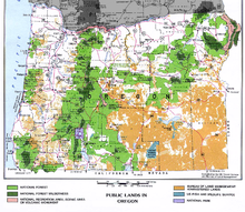
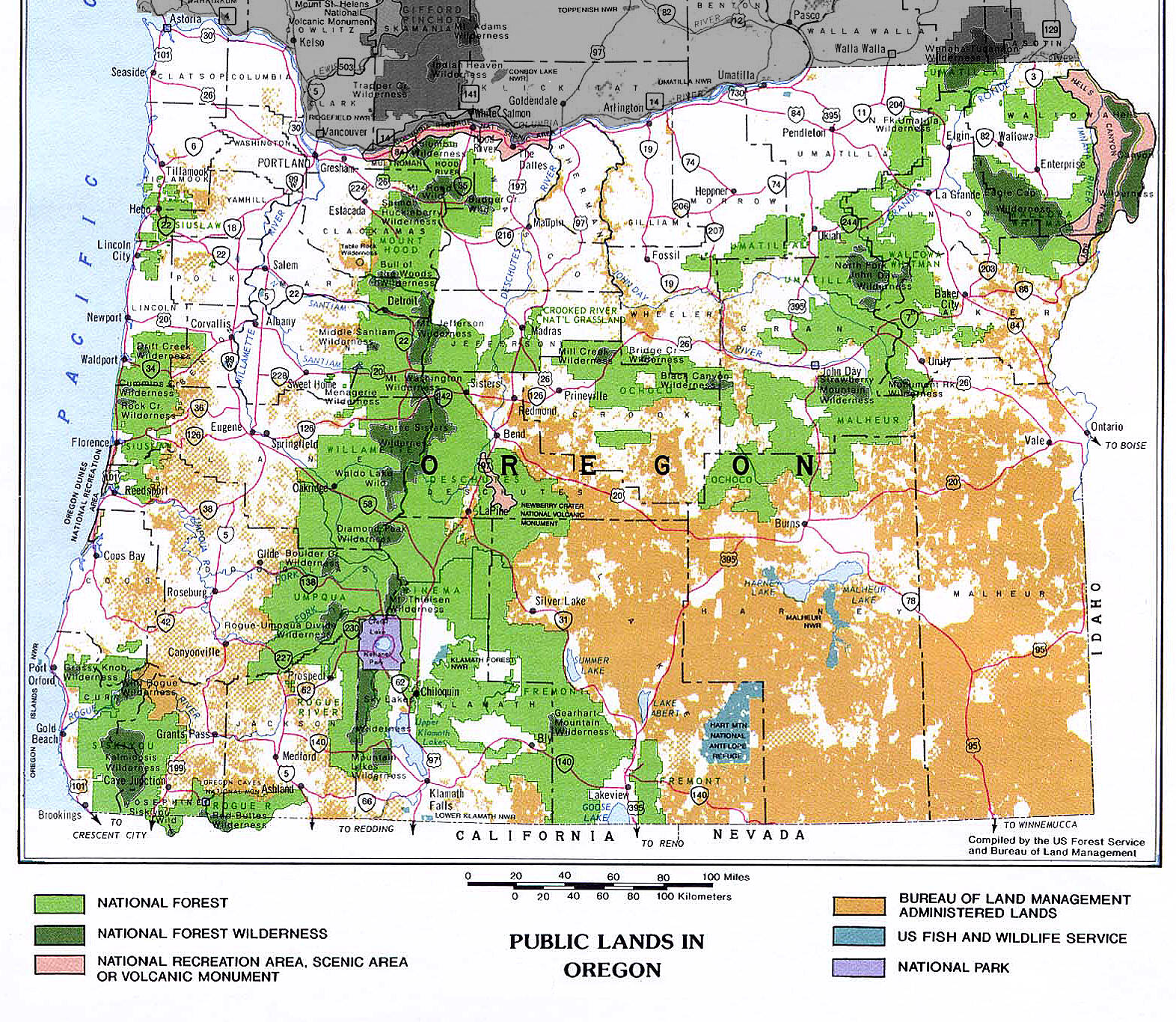
 National Forest wildernessNational ForestNational Recreation Area, Scenic Area, or Volcanic MonumentBureau of Land Management administered landsU.S. Fish and Wildlife ServiceNational Park
List of Oregon Wildernesses lists all 47 designated wildernesses in the U.S. state of Oregon.[1] [2][3] [4] [5]
Wilderness name acres designated administered by notes Badger Creek 24,000 1984 USFS [4] Black Canyon 13,400 1984 USFS [4] Boulder Creek 19,100 1984 USFS [4] Bridge Creek 5,400 1984 USFS [4] Bull of the Woods 27,427 1984 USFS [4] Clackamas 9,470 2009 USFS [4] Copper Salmon 13,700 2009 USFS [5] Cummins Creek 9,173 1984 USFS [4] Diamond Peak 54,185 1964 USFS [4] Drift Creek 5,798 1984 USFS [4] Eagle Cap 350,461 1964 USFS [4] Gearhart Mountain 22,809 1964 USFS [4] Grassy Knob 17,200 1984 USFS [4] Hells Canyon 214,944 (total)
131,133 (Oregon)1975, June 26, 1984 BLM+USFS [1][4] Kalmiopsis 179,755 1964 USFS [4] Lower White River 2,870 2009 BLM+USFS [1][4] Mark O. Hatfield 39,000 1984 USFS [4] Menagerie 4,800 1984 USFS [4] Middle Santiam 7,500 1984 USFS [4] Mill Creek 17,400 1984 USFS [4] Monument Rock 19,650 1984 USFS [4] Mount Hood 47,160 1964 USFS [4] Mount Jefferson 107,008 1968 USFS [4] Mount Thielsen 54,267 1984 USFS [4] Mount Washington 52,738 1964 USFS [4] Mountain Lakes 23,071 1964 USFS [4] North Fork John Day 121,352 1984 USFS [4] North Fork Umatilla 20,435 1984 USFS [4] Opal Creek 20,733 1996 USFS [4] Oregon Islands 925.06 October 23, 1970, October 11, 1978, November 12, 1996 USFWS [2] Oregon Badlands 29,301 2009 BLM [5] Red Buttes 19,940 (total)
3,750 (Oregon)1984 USFS [4] Roaring River 36,500 2009 USFS [6] Rock Creek 7,486 1984 USFS [4] Rogue–Umpqua Divide 33,200 1984 USFS [4] Salmon–Huckleberry 44,560 1984 USFS [4] Sky Lakes 116,300 1984 USFS [4] Soda Mountain 23,000 2009 BLM [5] Spring Basin 6,382 2009 BLM [5] Steens Mountain 170,025 October 30, 2000 BLM [1] Strawberry Mountain 69,350 1964 USFS [4] Table Rock 5,500 June 26, 1984 BLM [4] Three Arch Rocks 15 October 23, 1970 USFWS+USFS [2][4] first NWR west of Mississippi 1907 Three Sisters 286,708 1964 USFS [4] Waldo Lake 39,200 1984 USFS [4] Wenaha–Tucannon 177,423 (total)
66,375 (Oregon)1978 USFS [4] Wild Rogue 35,818 February 24, 1978 BLM+USFS [3] Total (acres) 2,395,390.06 (Oregon) 2,606,439.06 (total) Total (square miles) 3742.8 (Oregon) 4072.56 (total) Total (square km) 9693.84 (Oregon) 10547.93 (total) See also
References
- ^ a b c d Wilderness Database Details, October 2006
- ^ a b c Wilderness Areas
- ^ a b Wilderness.net- Wilderness Areas by State
- ^ a b c d e f g h i j k l m n o p q r s t u v w x y z aa ab ac ad ae af ag ah ai aj ak al am an Places - USFS History - Forest History Society
- ^ a b c d e "Omnibus Public Land Management Act of 2009". Library of Congress THOMAS. http://hdl.loc.gov/loc.uscongress/legislation.111hr146. Retrieved 2009-04-01.
- ^ Preusch, Matthew (April 6, 2009). "No cars, no roads, no kidding". The Oregonian. http://www.oregonlive.com/environment/index.ssf/2009/04/roaring_river_wilderness_area.html. Retrieved 2009-04-07.
Protected Areas of Oregon Federal State Arcadia Beach • Bob Straub • Bradley • Cape Kiwanda • Cape Lookout • Cape Meares • Clay Myers at Whalen Island • Del Rey Beach • Ecola • Elmer Feldenheimer • Fishing Rock • Fort Stevens • Gearhart Ocean • Haystack Hill • Hug Point • John Yeon • Manhattan Beach • Munson Creek Falls • Neahkahnie–Manzanita • Nehalem Bay • Oceanside Beach • Oswald West • Rockaway Beach • Sunset Beach • Sunset Highway Forest • Symons • Tolovana Beach • Tolovana Beach • Twin Rocks • Wilson River Highway Forest
Agate Beach • Alsea Bay • Beachside • Beaver Creek • Beverly Beach • Boiler Bay • Carl G. Washburne • Collins Creek • D River • Darlingtonia • Devils Lake • Devils Punch Bowl • Driftwood Beach • Ellmaker • Fogarty Creek • Gleneden Beach • Governor Patterson • H.B. Van Duzer • Heceta Head Lighthouse • Jessie M. Honeyman • Joaquin Miller Forest • L. Presley & Vera C. Gill • Lost Creek • Muriel O. Ponsler • Neptune • Neskowin Beach • Ona Beach • Otter Crest • Pritchard • Roads End • Rocky Creek • San Marine • Seal Rock • Smelt Sands • South Beach • Stonefield Beach • Tokatee Klootchman • W. B. Nelson • Whale Watching • Yachats • Yachats Ocean Road • Yaquina Bay
Albert H. Powers • Alfred A. Loeb • Arizona Beach • Bandon • Bolon Island Tideways • Bullards Beach • Cape Arago • Cape Blanco • Cape Sebastian • Conde B. McCullough • Coquille Myrtle Grove • Crissey Field • Elk Creek Tunnel Forest • Face Rock • Floras Lake • Geisel Monument • Golden and Silver Falls • Harris Beach • Hoffman • Humbug Mountain • Hutchinson • Maria C. Jackson • McVay Rock • Ophir • Otter Point • Paradise Point • Pistol River • Port Orford Cedar Forest • Port Orford Heads • Samuel H. Boardman • Seven Devils • Shore Acres • Sisters Rock • Sunset Bay • Sweet Myrtle • Umpqua • Umpqua Lighthouse • Umpqua Myrtle • William M. Tugman • Winchuck • Yoakam Point
Banks–Vernonia • Bonnie Lure • Government Island • L. L. "Stub" Stewart • Mary S. Young • Milo McIver • Tryon Creek • Willamette Stone
Ainsworth • Benson • Bonneville • Bridal Veil Falls • Crown Point • Dabney • Dalton Point • George W. Joseph • Guy W. Talbot • Historic Columbia River Highway • John B. Yeon • Koberg Beach • Lang Forest • Lewis and Clark • Lindsey Creek • Mayer • McLoughlin • Memaloose • Multnomah Falls • Portland Women's Forum • Rocky Butte • Rooster Rock • Seneca Fouts • Shepperd's Dell • Sheridan • Starvation Creek • Viento • Vinzenz Lausmann • Wyeth • Wygant
Alderwood • Bald Peak • Blachly Mountain Forest • Bowers Rock • Cascadia • Champoeg • Detroit Lake • Dexter • Elijah Bristow • Erratic Rock • Fall Creek • Fort Yamhill • Holman • Jasper • Lowell • Luckiamute • Maples • Maud Williamson • Molalla River • North Santiam • Sarah Helmick • Silver Falls • State Capitol • Thompson's Mills • Washburne • Willamette Mission
Ben Hur Lampman • Canyon Creek Forest • Casey • Collier Memorial • Illinois River Forks • Jackson F. Kimball • Joseph H. Stewart • Klamath Falls – Lakeview Forest • OC&E Woods Line • Prospect • Rough and Ready Forest • Stage Coach Forest • TouVelle • Tub Springs • Valley of the Rogue • Wolf Creek Inn
Cline Falls • Deschutes River • Dyer • Elliott Corbett • La Pine • Ochoco • Peter Skene Ogden • Pilot Butte • Prineville Reservoir • Redmond–Bend Juniper • Sisters • Smith Rock • The Cove Palisades • Tumalo • White River Falls
Bates • Battle Mountain Forest • Blue Mountain Forest • Booth • Catherine Creek • Chandler • Clyde Holliday • Crooked Creek • Deadman's Pass • Emigrant Springs • Farewell Bend • Fort Rock • Fort Rock Cave • Frenchglen Hotel • Goose Lake • Hat Rock • Hilgard Junction • Kam Wah Chung • Lake Owyhee • Minam • Ontario • Pete French Round Barn • Red Bridge • Succor Creek • Sumpter Valley Dredge • Ukiah–Dale Forest • Unity Forest • Unity Lake • Wallowa Lake • Wallowa Lake Highway Forest • Wallowa River
Bridge Creek • Dean Creek • Denman • E.E. Wilson • Elkhorn • Fern Ridge • Irrigon • Jewell Meadows • Klamath • Ladd Marsh • Lower Deschutes • Phillip W. Schneider • Prineville • Riverside • Sauvie Island • Snake River Islands • Summer Lake • Wenaha • White River • Willow Creek
Regions Portland metroBlue Lake • Cooper Mountain • Glendoveer • Howell • Oregon Zoo • Oxbow • Smith and Bybee • Mount Talbert
Cities PortlandForest Park • Washington Park
Categories:- Wilderness Areas of Oregon
- Oregon-related lists
Wikimedia Foundation. 2010.