- Cline Falls State Scenic Viewpoint
-
Cline Falls State Scenic Viewpoint
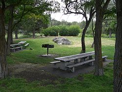
Picnic area at Cline Falls parkType Public, state Location Deschutes County, Oregon Nearest city Redmond Coordinates 44°16′07″N 121°15′21″W / 44.2687303°N 121.2558687°WCoordinates: 44°16′07″N 121°15′21″W / 44.2687303°N 121.2558687°W[1] Area 9 acres (3.6 ha) Operated by Oregon Parks and Recreation Department Cline Falls State Scenic Viewpoint (also known as Cline Falls State Park) is a state park near Redmond, Oregon, United States. It is located on the Deschutes River. The park covers 9 acres (36,000 m2). It is administered by the Oregon Parks and Recreation Department.
Contents
Cline Falls
Cline Falls are located on the Deschutes River approximately four miles west of Redmond, Oregon. The falls were named for Doctor C. A. Cline (1850–1926) a Redmond dentist, who owned the land adjacent to the falls. The falls occur just north of the point where Highway 126 crosses the Deschutes River.[2] In the 1950s, the Oregon Parks and Recreation Department acquired property above Cline Falls for the purpose of creating a day use park.[3]
Park grounds
Cline Falls State Scenic Viewpoint is a day use park that covers 9 acres (36,000 m2) on the east side of the Deschutes River. It is located on the south side of the Highway 126. Because Clines Falls are a short distance north of the highway, the falls are not within the park boundary.[4][5]
The park has a large open lawn surrounded by Ponderosa pine, Western juniper, poplar, and locust trees that extend to the river’s edge.[3][5] The park also includes riparian habitat, sagebrush covered uplands, and canyon rimrocks. These areas are home to Blackbirds, Canyon Wren, American Dipper, Song Sparrows, and finches. Other song birds pass through the area during the spring and fall migrations. Prairie Falcon and Golden Eagles are also found in the Cline Falls area.[5][6]
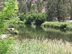
As it flows by the park, the Deschutes River alternates between small rapids and calm pools. The rapids pass around a number of very large boulders. The calm sections create wetlands along the shore that attract a variety of wildlife. Canadian Geese and other water fowl are common in the wetlands along the river.[3][4][5] A number of small mammals including the Great Basin Pocket Mouse and Sagebrush Voles are found in the park as well.[7]
Recreation
Since it is the closest river front park to the city of Redmond, Cline Falls State Scenic Viewpoint is a very popular recreation site for local residents. A large open lawn is available for group games and relaxing in the sun; however, most visitor come to the park to picnic and swim. The park offers a variety of swimming areas ranging from deep, calm pools to shallow coves. There are also short stretches of swift water for inner tubing.[3][4][5][8]
The park provides fishing access to the Deschutes River. The pools and eddies near large river rocks provide good habitat for trout. Fisherman can find native Rainbow trout, Brown trout, and Bull trout in the Cline Falls area.[4][5][9]
The Deschutes River provides excellent rafting, kayaking, and canoeing opportunities. One of the longer paddle trips on the Deschutes is a 14.5-mile (23.3 km) section of river beginning at Tumalo State Park and ending at Cline Falls State Park. Another popular run begins at Cline Falls park and runs 11.5 miles (18.5 km) down river to the Lower Bridge Recreation Site. This run requires a portage around Cline Falls, which is located about a half mile down stream from the park.[10]
Cline Falls State Scenic Viewpoint is closed during the winter months. When it is open, there is no charge for using the park. Alcohol is not permitted in the park at any time. The ban on alcohol is enforced by the Deschutes County Sheriff’s Department.[4][5][8] Park facilities include:
- Public restrooms with flush toilets[4]
- Picnic tables[4]
- Barbecue grills[8]
- Horseshoe pits[8]
- Fish-cleaning station[3]
Unsolved crime
On 22 June 1977, two undergraduate students from Yale University were attacked and badly injured in Cline Falls State Park. The two students were biking cross-country from Astoria, Oregon to the east coast. On the seventh day of their trip, they camped at Cline Falls State Park. In the middle of the night, a truck drove over their tent with the two campers inside. Then the driver got out of the truck and attacked the students with an axe. After striking them a number of times, the attacker stopped and drove away. Both students survived. However, their attacker was never caught. One of the survivors later wrote a book about the ordeal entitled Strange Piece of Paradise.[11][12]
See also
References
- ^ "Cline Falls State Park". Geographic Names Information System, U.S. Geological Survey. http://geonames.usgs.gov/pls/gnispublic/f?p=gnispq:3:::NO::P3_FID:1119026. Retrieved 2011-06-21.
- ^ McArthur, Lewis A; Lewis L McArthur (2003). Oregon Geographic Names (7th ed.). Portland, Oregon: Oregon Historical Society Press. p. 210.
- ^ a b c d e Hole, Leslie Pugmire (23 June 2009). "Cline Falls: The Oasis". Redmond Spokesman. http://redmondspokesman.blogspot.com/2009/06/cline-falls-oasis.html. Retrieved 2011-06-21.
- ^ a b c d e f g "Cline Falls State Scenic Viewpoint". Oregon Parks and Recreation Department. http://www.oregonstateparks.org/park_38.php. Retrieved 2011-06-21.
- ^ a b c d e f g Bannan, Jan (2002). Oregon State Parks: A Complete Recreation Guide (2nd ed.). Seattle, Washington: The Mountaineers Books. p. 174. ISBN 0898867940. http://books.google.com/books?id=boFO8l8R7BsC&pg=PA174&lpg=PA174&dq=%22cline+falls%22&source=web&ots=SZQ3sAMolr&sig=C1YHhY0K28r9bImGrqKERmd1QI4&hl=en&sa=X&oi=book_result&resnum=2&ct=result.
- ^ "Oregon Cascades Birding Trails". East Cascade Bird Conservancy. http://www.oregonbirdingtrails.org/cascguide/trailguide.pdf. Retrieved 2011-06-21..
- ^ Verts, B. J; Leslie N. Carraway (1998). Land mammals of Oregon. Berkeley, California: University of California Press. pp. 520, 539. ISBN 0520211995. http://books.google.com/books?id=8KI1AmzIDnwC&pg=RA1-PA539&lpg=RA1-PA539&dq=wildlife+%22Cline+Falls+State+Park%22+oregon&source=bl&ots=SwCE3nhcux&sig=35OmEXQ2Qh24FPE3bnVBliNn8u8&hl=en&ei=6vbkSsXnKYecMKyVwbsB&sa=X&oi=book_result&ct=result&resnum=10&ved=0CCYQ6AEwCTgU#v=onepage&q=wildlife%20%22Cline%20Falls%20State%20Park%22%20oregon&f=false.
- ^ a b c d "Monitor Cline Falls park". Redmond Spokesman (Redmond, Oregon). March 18, 2008. http://redmondspokesman.blogspot.com/2008/03/monitor-cline-falls-park.html. Retrieved 2011-06-21.
- ^ "Rivers and Streams: Deschutes River from Bend to Lake Billy Chinook". US Forest Service. Archived from the original on 2008-06-03. http://web.archive.org/web/20080603033945/http://www.fs.fed.us/r6/centraloregon/recreation/fishing/river-stream/bend-billy.shtml. Retrieved 2011-06-21.
- ^ Giordano, Pete; Willamette Kayak and Canoe Club (2004). "Deschutes River Tumalo State Park to Cline Falls State Park". Soggy sneakers: a paddler's guide to Oregon's rivers (4th ed.). Seattle Washington: Mountaineers Books. pp. 301–304. ISBN 0898868157. http://books.google.com/books?id=hvVWeTVVoaMC&lpg=PA301&ots=bKkzRJlfTx&dq=%22Cline%20Falls%20state%20Park%22%20oregon&pg=PA301#v=onepage&q=%22Cline%20Falls%20state%20Park%22%20oregon&f=false.
- ^ Jasper, David (July 22, 2007). "Ax-attack survivor, author tells all". The Bulletin (Bend Oregon). http://www.bendbulletin.com/apps/pbcs.dll/article?AID=/20070722/NEWS0107/707220324/1001&nav_category=. Retrieved 2011-06-21.,
- ^ Santasiero, Ellen. "Left For Dead: Cline Falls ax attack survivor to discuss acclaimed memoir". Bend, Oregon: The Weekly Source. http://www.tsweekly.com/culture/words/left-for-deadcline-falls-ax-attack-survivor-to-discuss-acclaimed-memoir.html. Retrieved 2011-06-21.
External links
- "Cline Falls State Scenic Viewpoint". Oregon Parks and Recreation Department. http://www.oregonstateparks.org/park_38.php. Retrieved 2011-06-21.
Protected Areas of Oregon Federal State Arcadia Beach • Bob Straub • Bradley • Cape Kiwanda • Cape Lookout • Cape Meares • Clay Myers at Whalen Island • Del Rey Beach • Ecola • Elmer Feldenheimer • Fishing Rock • Fort Stevens • Gearhart Ocean • Haystack Hill • Hug Point • John Yeon • Manhattan Beach • Munson Creek Falls • Neahkahnie–Manzanita • Nehalem Bay • Oceanside Beach • Oswald West • Rockaway Beach • Sunset Beach • Sunset Highway Forest • Symons • Tolovana Beach • Tolovana Beach • Twin Rocks • Wilson River Highway Forest
Agate Beach • Alsea Bay • Beachside • Beaver Creek • Beverly Beach • Boiler Bay • Carl G. Washburne • Collins Creek • D River • Darlingtonia • Devils Lake • Devils Punch Bowl • Driftwood Beach • Ellmaker • Fogarty Creek • Gleneden Beach • Governor Patterson • H.B. Van Duzer • Heceta Head Lighthouse • Jessie M. Honeyman • Joaquin Miller Forest • L. Presley & Vera C. Gill • Lost Creek • Muriel O. Ponsler • Neptune • Neskowin Beach • Ona Beach • Otter Crest • Pritchard • Roads End • Rocky Creek • San Marine • Seal Rock • Smelt Sands • South Beach • Stonefield Beach • Tokatee Klootchman • W. B. Nelson • Whale Watching • Yachats • Yachats Ocean Road • Yaquina Bay
Albert H. Powers • Alfred A. Loeb • Arizona Beach • Bandon • Bolon Island Tideways • Bullards Beach • Cape Arago • Cape Blanco • Cape Sebastian • Conde B. McCullough • Coquille Myrtle Grove • Crissey Field • Elk Creek Tunnel Forest • Face Rock • Floras Lake • Geisel Monument • Golden and Silver Falls • Harris Beach • Hoffman • Humbug Mountain • Hutchinson • Maria C. Jackson • McVay Rock • Ophir • Otter Point • Paradise Point • Pistol River • Port Orford Cedar Forest • Port Orford Heads • Samuel H. Boardman • Seven Devils • Shore Acres • Sisters Rock • Sunset Bay • Sweet Myrtle • Umpqua • Umpqua Lighthouse • Umpqua Myrtle • William M. Tugman • Winchuck • Yoakam Point
Banks–Vernonia • Bonnie Lure • Government Island • L. L. "Stub" Stewart • Mary S. Young • Milo McIver • Tryon Creek • Willamette Stone
Ainsworth • Benson • Bonneville • Bridal Veil Falls • Crown Point • Dabney • Dalton Point • George W. Joseph • Guy W. Talbot • Historic Columbia River Highway • John B. Yeon • Koberg Beach • Lang Forest • Lewis and Clark • Lindsey Creek • Mayer • McLoughlin • Memaloose • Multnomah Falls • Portland Women's Forum • Rocky Butte • Rooster Rock • Seneca Fouts • Shepperd's Dell • Sheridan • Starvation Creek • Viento • Vinzenz Lausmann • Wyeth • Wygant
Alderwood • Bald Peak • Blachly Mountain Forest • Bowers Rock • Cascadia • Champoeg • Detroit Lake • Dexter • Elijah Bristow • Erratic Rock • Fall Creek • Fort Yamhill • Holman • Jasper • Lowell • Luckiamute • Maples • Maud Williamson • Molalla River • North Santiam • Sarah Helmick • Silver Falls • State Capitol • Thompson's Mills • Washburne • Willamette Mission
Ben Hur Lampman • Canyon Creek Forest • Casey • Collier Memorial • Illinois River Forks • Jackson F. Kimball • Joseph H. Stewart • Klamath Falls – Lakeview Forest • OC&E Woods Line • Prospect • Rough and Ready Forest • Stage Coach Forest • TouVelle • Tub Springs • Valley of the Rogue • Wolf Creek Inn
Cline Falls • Deschutes River • Dyer • Elliott Corbett • La Pine • Ochoco • Peter Skene Ogden • Pilot Butte • Prineville Reservoir • Redmond–Bend Juniper • Sisters • Smith Rock • The Cove Palisades • Tumalo • White River Falls
Bates • Battle Mountain Forest • Blue Mountain Forest • Booth • Catherine Creek • Chandler • Clyde Holliday • Crooked Creek • Deadman's Pass • Emigrant Springs • Farewell Bend • Fort Rock • Fort Rock Cave • Frenchglen Hotel • Goose Lake • Hat Rock • Hilgard Junction • Kam Wah Chung • Lake Owyhee • Minam • Ontario • Pete French Round Barn • Red Bridge • Succor Creek • Sumpter Valley Dredge • Ukiah–Dale Forest • Unity Forest • Unity Lake • Wallowa Lake • Wallowa Lake Highway Forest • Wallowa River
Bridge Creek • Dean Creek • Denman • E.E. Wilson • Elkhorn • Fern Ridge • Irrigon • Jewell Meadows • Klamath • Ladd Marsh • Lower Deschutes • Phillip W. Schneider • Prineville • Riverside • Sauvie Island • Snake River Islands • Summer Lake • Wenaha • White River • Willow Creek
Regions Portland metroBlue Lake • Cooper Mountain • Glendoveer • Howell • Oregon Zoo • Oxbow • Smith and Bybee • Mount Talbert
Cities PortlandForest Park • Washington Park
Heritage registers: National Register of Historic Places • National Historic Landmarks • National Natural Landmarks • World Network of Biosphere Reserves Categories:- Oregon state parks
- Parks in Deschutes County, Oregon
Wikimedia Foundation. 2010.


