- Deschutes River State Recreation Area
-
Deschutes River State Recreation Area 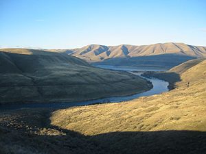
Confluence of the Deschutes and the Columbia, as viewed from near the hiking trail on December 25, 2003

Type Public, state Location Sherman County, Oregon Nearest city The Dalles Coordinates 45°38′01″N 120°54′35″W / 45.6334862°N 120.909605°WCoordinates: 45°38′01″N 120°54′35″W / 45.6334862°N 120.909605°W[1] Area 35.1 acres (14.2 ha) Operated by Oregon Parks and Recreation Department Status Open The Deschutes River State Recreation Area is a park at the confluence of the Deschutes and Columbia rivers in the U.S. state of Oregon. It is a few miles east of The Dalles. The 35.1-acre (14.2 ha) park offers opportunities for camping, fishing, hiking, mountain biking, and equestrian trail riding.
Contents
History
The chamber of commerce in The Dalles pushed for a state park at the location beginning in 1955. After years of studies, the state acquired the first tract of land in 1963, when it purchased 30 acres (12 ha) from the Columbia-Deschutes Power Company. In 1963, an additional 5.1 acres (2.1 ha) were purchased from the Miller family and added to the park.[2]
Details
Deschutes River is one of 28 state parks in Oregon with year-round campgrounds although water is turned off during the winter. There are 34 campsites suitable for recreational vehicles, with electrical and water available. An additional 25 primitive sites with drinking water and facilities nearby are available.[3] The park is along the Oregon Trail and rents a covered wagon for camping.[4] The park includes showers, mowed lawns, and wildlife viewing.[4] Hiking and biking opportunities include a trail named for former governor Victor G. Atiyeh that runs along the Deschutes.[5] Hunting is also available for pheasant, Chukar, and Hungarian partridge during designated seasons for each.[6] Located on the east shore of the Deschutes River, Heritage Landing boat ramp is on the opposite shore of the park,[4] with the Lower Deschutes Wildlife Area about one mile (1.6 km) upriver.[7]
References
- ^ "Deschutes River State Park". Geographic Names Information System, U.S. Geological Survey. http://geonames.usgs.gov/pls/gnispublic/f?p=gnispq:3:::NO::P3_FID:1119877. Retrieved 2011-06-26.
- ^ Armstrong, Chester H (1965). Oregon State Parks: History, 1917-1963. Salem, OR: Oregon State Highway Department. p. 116–117. OCLC 5694863.
- ^ "Deschutes River State Recreation Area" (brochure). Oregon Parks and Recreation Department. http://www.oregonstateparks.org/images/pdf/deschutes_full.pdf. Retrieved 2011-06-26.
- ^ a b c Richard, Terry. Weekend getaways / Sunny Eastern Gorge. The Oregonian, March 13, 2005.
- ^ Mapes, Jeff. Deschutes River canyon trails exhilarate cyclists; Even beginners fall in love with the spectacular vistas and challenging terrain. The Oregonian, August 6, 2000.
- ^ Foden-Vencil, Kristian. Off-season delights. The Oregonian, November 16, 1995.
- ^ Gault, Roy. Wildlife Viewing. Statesman Journal, March 16, 2007.
External links
- "Deschutes River State Recreation Area". Oregon Parks and Recreation Department. http://www.oregonstateparks.org/park_37.php. Retrieved 2011-06-26.
Protected Areas of Oregon Federal State Arcadia Beach • Bob Straub • Bradley • Cape Kiwanda • Cape Lookout • Cape Meares • Clay Myers at Whalen Island • Del Rey Beach • Ecola • Elmer Feldenheimer • Fishing Rock • Fort Stevens • Gearhart Ocean • Haystack Hill • Hug Point • John Yeon • Manhattan Beach • Munson Creek Falls • Neahkahnie–Manzanita • Nehalem Bay • Oceanside Beach • Oswald West • Rockaway Beach • Sunset Beach • Sunset Highway Forest • Symons • Tolovana Beach • Tolovana Beach • Twin Rocks • Wilson River Highway Forest
Agate Beach • Alsea Bay • Beachside • Beaver Creek • Beverly Beach • Boiler Bay • Carl G. Washburne • Collins Creek • D River • Darlingtonia • Devils Lake • Devils Punch Bowl • Driftwood Beach • Ellmaker • Fogarty Creek • Gleneden Beach • Governor Patterson • H.B. Van Duzer • Heceta Head Lighthouse • Jessie M. Honeyman • Joaquin Miller Forest • L. Presley & Vera C. Gill • Lost Creek • Muriel O. Ponsler • Neptune • Neskowin Beach • Ona Beach • Otter Crest • Pritchard • Roads End • Rocky Creek • San Marine • Seal Rock • Smelt Sands • South Beach • Stonefield Beach • Tokatee Klootchman • W. B. Nelson • Whale Watching • Yachats • Yachats Ocean Road • Yaquina Bay
Albert H. Powers • Alfred A. Loeb • Arizona Beach • Bandon • Bolon Island Tideways • Bullards Beach • Cape Arago • Cape Blanco • Cape Sebastian • Conde B. McCullough • Coquille Myrtle Grove • Crissey Field • Elk Creek Tunnel Forest • Face Rock • Floras Lake • Geisel Monument • Golden and Silver Falls • Harris Beach • Hoffman • Humbug Mountain • Hutchinson • Maria C. Jackson • McVay Rock • Ophir • Otter Point • Paradise Point • Pistol River • Port Orford Cedar Forest • Port Orford Heads • Samuel H. Boardman • Seven Devils • Shore Acres • Sisters Rock • Sunset Bay • Sweet Myrtle • Umpqua • Umpqua Lighthouse • Umpqua Myrtle • William M. Tugman • Winchuck • Yoakam Point
Banks–Vernonia • Bonnie Lure • Government Island • L. L. "Stub" Stewart • Mary S. Young • Milo McIver • Tryon Creek • Willamette Stone
Ainsworth • Benson • Bonneville • Bridal Veil Falls • Crown Point • Dabney • Dalton Point • George W. Joseph • Guy W. Talbot • Historic Columbia River Highway • John B. Yeon • Koberg Beach • Lang Forest • Lewis and Clark • Lindsey Creek • Mayer • McLoughlin • Memaloose • Multnomah Falls • Portland Women's Forum • Rocky Butte • Rooster Rock • Seneca Fouts • Shepperd's Dell • Sheridan • Starvation Creek • Viento • Vinzenz Lausmann • Wyeth • Wygant
Alderwood • Bald Peak • Blachly Mountain Forest • Bowers Rock • Cascadia • Champoeg • Detroit Lake • Dexter • Elijah Bristow • Erratic Rock • Fall Creek • Fort Yamhill • Holman • Jasper • Lowell • Luckiamute • Maples • Maud Williamson • Molalla River • North Santiam • Sarah Helmick • Silver Falls • State Capitol • Thompson's Mills • Washburne • Willamette Mission
Ben Hur Lampman • Canyon Creek Forest • Casey • Collier Memorial • Illinois River Forks • Jackson F. Kimball • Joseph H. Stewart • Klamath Falls – Lakeview Forest • OC&E Woods Line • Prospect • Rough and Ready Forest • Stage Coach Forest • TouVelle • Tub Springs • Valley of the Rogue • Wolf Creek Inn
Cline Falls • Deschutes River • Dyer • Elliott Corbett • La Pine • Ochoco • Peter Skene Ogden • Pilot Butte • Prineville Reservoir • Redmond–Bend Juniper • Sisters • Smith Rock • The Cove Palisades • Tumalo • White River Falls
Bates • Battle Mountain Forest • Blue Mountain Forest • Booth • Catherine Creek • Chandler • Clyde Holliday • Crooked Creek • Deadman's Pass • Emigrant Springs • Farewell Bend • Fort Rock • Fort Rock Cave • Frenchglen Hotel • Goose Lake • Hat Rock • Hilgard Junction • Kam Wah Chung • Lake Owyhee • Minam • Ontario • Pete French Round Barn • Red Bridge • Succor Creek • Sumpter Valley Dredge • Ukiah–Dale Forest • Unity Forest • Unity Lake • Wallowa Lake • Wallowa Lake Highway Forest • Wallowa River
Bridge Creek • Dean Creek • Denman • E.E. Wilson • Elkhorn • Fern Ridge • Irrigon • Jewell Meadows • Klamath • Ladd Marsh • Lower Deschutes • Phillip W. Schneider • Prineville • Riverside • Sauvie Island • Snake River Islands • Summer Lake • Wenaha • White River • Willow Creek
Regions Portland metroBlue Lake • Cooper Mountain • Glendoveer • Howell • Oregon Zoo • Oxbow • Smith and Bybee • Mount Talbert
Cities PortlandForest Park • Washington Park
Categories:- Oregon state parks
- Parks in Sherman County, Oregon


Wikimedia Foundation. 2010.