- Rogue-Umpqua Divide Wilderness
Infobox_protected_area | name = Rogue-Umpqua Divide Wilderness
iucn_category = Ib
caption =
locator_x =
locator_y =
location =Oregon ,USA
nearest_city =Eagle Point, Oregon
lat_degrees = 43
lat_minutes = 03
lat_seconds = 59
lat_direction = N
long_degrees = 122
long_minutes = 27
long_seconds = 46
long_direction = W
area = convert|33200|acre|km2
established =1984
visitation_num =
visitation_year =
governing_body =United States Forest Service The Rogue-Umpqua Divide Wilderness is a
wilderness area located in the Rogue River-Siskiyou and Umpqua National Forests in theKlamath Mountains ofOregon ,United States . It was established by theUnited States Congress in 1984 and comprises convert|33200|acre|km2. [http://www.fs.fed.us/r6/rogue-siskiyou/recreation/wilderness/rogue-umpqua-divide.shtml Rogue River-Siskiyou National Forest] ]Topography
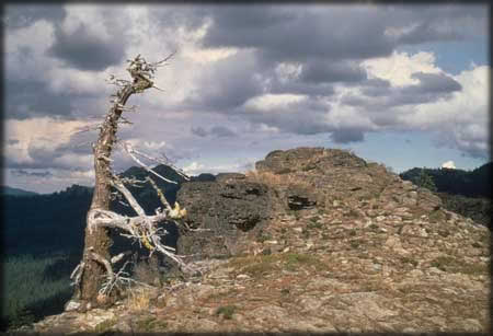
The Rogue Umpqua Divide Wilderness is located ten miles west of
Crater Lake National Park along the dividing ridge between the Rogue and Umpqua Rivers. Elevations range from convert|3000|ft|m to convert|6783|ft|m at the summit of Fish Mountain. Volcanic activity created many unique volcanic andsedimentary rock outcrops. [ [http://www.publiclands.org/explore/site.php?id=4189&PHPSESSID=23cfeb7c9 Rogue-Umpqua Divide Wilderness] - Public Lands Information Center]Vegetation
Most of the Rogue-Umpqua Divide is covered in a dense forest composed of
sugar pine ,grand fir ,mountain hemlock ,western white pine ,incense cedar ,subalpine fir ,western redcedar ,white fir ,ponderosa pine ,Douglas-fir ,Alaska cedar , shastared fir ,lodgepole pine ,pacific silver fir ,western hemlock , andwhitebark pine . [http://www.fs.fed.us/r6/umpqua/recreation/wilderness/rogue-umpqua-divide-wilderness.shtml Umpqua National Forest] ]The Acker Divide and Cripple Camp trails lead through large stands of
old-growth forests.Recreation
Popular recreational activities in the Wilderness include hiking, camping, and wildlife watching. Approximately convert|100|mi|km of trails criss-cross the wilderness. The most popular is the convert|31.4|mi|km|sign=on Rogue-Umpqua Divide National Recreation Trail, which offers exceptional views to the east and west as it weaves across the crest of the divide. [ [http://gorp.away.com/gorp/resource/us_wilderness_area/or_roguw.htm Rogue-Umpqua Divide Wilderness, Oregon] - GORP]
References
ee also
*
List of Oregon Wildernesses
*List of U.S. Wilderness Areas
*Wilderness Act External links
* [http://www.fs.fed.us/r6/rogue-siskiyou/recreation/wilderness/rogue-umpqua-divide.shtml Rogue-Umpqua Divide Wilderness] - Rogue River-Siskiyou National Forest
* [http://www.fs.fed.us/r6/umpqua/recreation/wilderness/rogue-umpqua-divide-wilderness.shtml Rogue-Umpqua Divide Wilderness] - Umpqua National Forest
Wikimedia Foundation. 2010.