- Umpqua River
Infobox River
river_name = Umpqua River
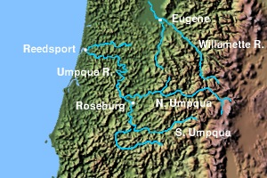
caption = Umpqua River with tributaries
origin = Confluence of North and South Umpqua NW ofRoseburg, Oregon
mouth =Pacific Ocean
basin_countries =USA
length = 111 miles (179 km)
elevation = ~360 feet above sea level (110 m)
mouth_elevation = sea level
discharge = 4,920 cubic feet/s (148 m³/s) at Elkton
watershed =The Umpqua River (UHMP-kwah) on the Pacific coast of
Oregon in theUnited States is approximately convert|111|mi|km|0 long. One of the principal rivers of the Oregon coast, it drains an expansive network of valleys in the mountains west of theCascade Range and south of theWillamette Valley , from which it is separated by theCalapooya Mountains . The "Hundred Valleys of the Umpqua" form the timber-producing heart of southern Oregon centered on Roseburg. The river flows entirely within Douglas County, which encompasses most of the watershed of the river from the Cascades to the coast.It is formed by the confluence of the North Umpqua and South Umpqua rivers, both of which rise in the Cascades, approximately convert|6|mi|km|1 northwest of Roseburg. In modern terminology, the "Umpqua Valley" is sometimes taken to refer to the populated lower reaches of the South Umpqua south of Roseburg, along the route of
Interstate 5 . The North Umpqua rises from snowmelt and is considered one of the premier summer steelhead streams in the West. The combined river flows generally northwest through theOregon Coast Range in a serpentine course past Umpqua and Elkton. At Elkton it turns to flow west past Scottsburg, which is located at thehead of tide . It entersWinchester Bay on the Pacific at Reedsport. It receives the Smith River from the north near itsestuary on Winchester Bay. TheUmpqua River Light house protects the mouth of the river. TheUmpqua River is one of only three rivers that start in, or east of theCascade Mountain Range and reach thePacific Ocean . The others are theRogue River andKlamath River .In the early 19th century the river valley was largely inhabited by the Coquille tribe of Native Americans. The tribe ceded most of its land to the U.S. government in the 1854
Kalapuya Treaty , agreeing to move to a reservation in Lincoln County as part of theConfederated Tribes of Siletz . The river itself is named for the Umpqua, a band of the Coquille.The Umpqua River valley was inhabited by several different bands of Indians; primarily the Athabaskan speaking Upper Umpqua, Takelman speaking Cow Creek Band of Umpqua, the Yoncalla (a Kalapuyan people) in the north, and the Quich (Lower Umpqua) from Scottsburg/Wells Creek to the coast. The Quich spoke a language distantly related to Alsea/Yakonan and the Coos Bay languages.
The Umpqua River boasts some of the world's best fly-fishing, salmon fishing, and sturgeon fishing. Umpqua river fishing is also famous for its small-mouth bass, striped bass, and shad population. [ [http://www.loonlakerv.com/umpqua-river.html Umpqua River RV Park, Camping, Umpqua River Lodging and Information ] ]
References
External links
* [http://www.coastalatlas.net/learn/settings/estuary/estuary.asp?es=13 Oregon Coastal Atlas: Umpqua River Estuary]
* [http://umpquaexplorer.info/ The Umpqua Basin Explorer] fromOregon State University
Wikimedia Foundation. 2010.