- Mount Rainier National Park
-
Mount Rainier National Park IUCN Category II (National Park)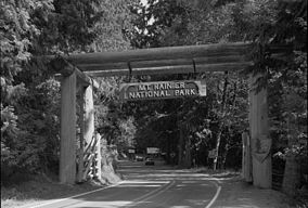
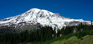
Nisqually entranceLocation Pierce County and Lewis County, Washington, USA Nearest city Tacoma Coordinates 46°51′N 121°45′W / 46.85°N 121.75°WCoordinates: 46°51′N 121°45′W / 46.85°N 121.75°W Area 235,625 acres (953.5 km2) Established 2 March 1899 Visitors 1,113,601 (in 2010) Governing body National Park Service Mount Rainier National Park is a United States National Park located in southeast Pierce County and northeast Lewis County in Washington state.[1] It was one of the US's earliest National Parks, having been established on March 2, 1899 as the fifth national park in the United States. The park contains 368 square miles (950 km2) including all of Mount Rainier, a 14,411-foot (4,392 m) stratovolcano.[2] The mountain rises abruptly from the surrounding land with elevations in the park ranging from 1,600 feet (490 m) to over 14,000 feet (4,300 m). The highest point in the Cascade Range, around it are valleys, waterfalls, subalpine wildflower meadows, old growth forest and more than 26 glaciers. The volcano is often shrouded in clouds that dump enormous amounts of rain and snow on the peak every year and hide it from the crowds that head to the park on weekends.
Mount Rainier is circled by the Wonderland Trail and is covered by several glaciers and snowfields totaling some 35 square miles (91 km2). Carbon Glacier is the largest glacier by volume in the continental United States, while Emmons Glacier is the largest glacier by area. About 1.3 million people visit Mount Rainier National Park each year. Mount Rainier is a popular peak for mountain climbing with some 10,000 attempts per year with approximately 25% making it to the summit.
The park contains outstanding subalpine meadows and 91,000 acres (370 km2) of old growth forests.[3]
Contents
History
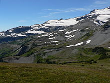
Ohanapecosh Park is one of many named subalpine areas that may be reached via the Wonderland Trail.
Ninety-seven percent of the park is preserved as wilderness under the National Wilderness Preservation System, including Clearwater Wilderness and Mount Rainier Wilderness, a designation it received in 1988. It is abutted by the Tatoosh Wilderness. The park was designated a National Historic Landmark on 18 February 1997 as a showcase for the National Park Service Rustic style architecture (or parkitecture) of the 1920s and 1930s, exemplified by the Paradise Inn and a masterpiece of early NPS master planning. As an Historic Landmark district, the park was administratively listed on the National Register of Historic Places.[4]
Native Americans
The earliest evidence of human activity in the area which is now Mount Rainier National Park is a projectile point dated to circa 4,000-5,800 BP (before present) found along Bench Lake Trail (the first section of Snow Lake Trail).[5][6]
A more substantial archeological find was a rock shelter near Fryingpan Creek, east of Goat Island Mountain. Hunting artifacts were found in the shelter. The shelter would not have been used all year round. Cultural affinities suggest the site was used by Columbia Plateau Tribes from 1000 to 300 BP.[5][6]
In 1963 the National Park Service contracted the Washington State University to study Native American use of the Mount Rainier area. Richard D. Daugherty lead an archeological study of the area and concluded that prehistoric humans used the area most heavily between 8000 and 4500 BP. Allan H. Smith interviewed elderly Native Americans and studied ethnographic literature. He found no evidence of permanent habitation in the park area. The park was used for hunting and gathering and for occasional spirit quests. Smith also came to tentative conclusions that the park was divided among five tribes along watershed boundaries; the Nisqually, Puyallup, Muckleshoot, Yakama, and Taidnapam (Upper Cowlitz). Subsequent studies cast doubt on Smith's theory that the tribes had agreed upon boundaries before they entered into treaties with the United States in 1854-55.[5]
Park creation
The Mount Rainier Forest Preserve should be made a national park and guarded while yet its bloom is on; for if in the making of the West Nature had what we call parks in mind—places for rest, inspiration, and prayers—this Rainier region must surely be one of them.
 At the summit of Mount Rainier, 1888. Left to right: D.W. Bass, P. B. Van Trump, John Muir, N.O. Booth, Edward Sturgis Ingraham. Photograph by Arthur Churchill Warner
On March 2, 1899, President William McKinley signed a bill passed by Congress authorizing the creation of Mount Rainier National Park, the nation's fifth national park.[8] It was the first national park created from a national forest.[7] The Pacific Forest Reserve had been created in 1893 and included Mount Rainier. It was enlarged in 1897 and renamed Mount Rainier Forest Reserve. John Muir had visited Mount Rainier in 1888. Muir and nine others, including Edward Sturgis Ingraham, Charles Piper, and P. B. Van Trump, climbed to the summit in what became the fifth recorded ascent.[9][10] The trip to Mount Rainier had played a role in reinvigorating Muir and convincing him to rededicate his life to the preservation of nature as national parks. At the time national forests, called forest reserves at first, were being created throughout the American West, under the utilitarian "conservation-through-use" view of Gifford Pinchot. Muir was what came to be known as a "preservationist". He wanted nature preserved under the more protected status of national parks. But during the 1890s there was more public support for creating national forests than national parks. During that decade, Muir and his supporters were only able to protect one national forest as a national park. When the Pacific Forest Reserve was created in 1893, Muir quickly persuaded the newly formed Sierra Club to support a movement to protect Rainier as a national park. Other groups soon joined, such as the National Geographic Society and scientific associations wanting Mount Rainier preserved as a place to study volcanism and glaciology. Commercial leaders in Tacoma and Seattle were also in support, as was the Northern Pacific Railway. The effort lasted over five years and involved six different attempts to push a bill through Congress. Congress eventually agreed, but only after acquiring assurances that none of the new park was suitable for farming or mining and that no federal appropriations would be necessary for its management.[7]
2006 flooding
Mount Rainier National Park closed because of extensive flooding as a result of the 6 November 2006 Pineapple Express rainstorm when 18 inches (460 mm) of rain fell in a 36 hour period. Campsites and roads throughout the park were washed away. Power to Paradise and Longmire was disrupted.[11] On 5 May 2007, the park reopened to automobile traffic via State Route 706 at the Nisqually Entrance.[12]
Major attractions
The entire park was designated a National Historic Landmark District on February 18, 1997, in recognition of the consistently high standard of design and preservation the park's National Park Service Rustic-style architecture.[13] The park contains 42 locations designated on the National Register of Historic Places, including four National Historic Landmarks.
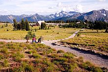
Paradise
Main article: Paradise, WashingtonParadise (46°47′N 121°44′W / 46.79°N 121.74°W[14]) is the name of an area at approximately 5,400 feet (1,600 m) on the south slope of Mount Rainier in the national park. Paradise is the most popular destination for visitors to Mount Rainier National Park.[15] 62% of the over 1.3 million people who visited the park in 2000 went to Paradise.[16] Paradise is the location of the historic Paradise Inn (built 1916),[17] Paradise Guide House (built 1920) and Henry M. Jackson Visitor Center (built 1966;[18] demolished and replaced, 2008). [19] The National Park Service says that "Paradise is the snowiest place on Earth where snowfall is measured regularly."[20] 1,122 inches (93.5 ft, 28.5 m) of snow fell during the winter of 1971/72, setting a world record for that year[20][21] Subsequently, in the winter of 1998/99, Mount Baker Ski Area received 1140 inches (95 ft, 29 m) [22] Paradise holds the Cascade Range record for most snow on the ground with 367 inches (9.32 m) on 10 March 1956.[23]
Climate data for Paradise (1916-2010) Month Jan Feb Mar Apr May Jun Jul Aug Sep Oct Nov Dec Year Record high °F (°C) 65
(18)62
(17)70
(21)78
(26)88
(31)86
(30)87
(31)94
(34)89
(32)88
(31)78
(26)66
(19)94
(34)Average high °F (°C) 32.3
(0.2)34.3
(1.3)36.1
(2.3)41.6
(5.3)48.6
(9.2)53.9
(12.2)62.2
(16.8)62.6
(17.0)57.1
(13.9)47.6
(8.7)37.7
(3.2)33.0
(0.6)45.58
(7.55)Average low °F (°C) 20.5
(−6.4)21.5
(−5.8)22.2
(−5.4)25.7
(−3.5)31.4
(−0.3)36.6
(2.6)42.7
(5.9)43.6
(6.4)39.7
(4.3)32.8
(0.4)25.6
(−3.6)21.1
(−6.1)30.28
(−0.95)Record low °F (°C) −13
(−25)−18
(−28)−2
(−19)2
(−17)13
(−11)13
(−11)20
(−7)26
(−3)18
(−8)2
(−17)−11
(−24)−20
(−29)−20
(−29)Precipitation inches (mm) 17.46
(443.5)12.16
(308.9)11.63
(295.4)7.68
(195.1)4.97
(126.2)4.27
(108.5)1.75
(44.5)2.55
(64.8)5.39
(136.9)10.04
(255)16.19
(411.2)17.95
(455.9)112.04
(2,845.8)Snowfall inches (cm) 129.4
(328.7)94.4
(239.8)104.6
(265.7)61.2
(155.4)22.5
(57.2)5.9
(15)0.4
(1)0.1
(0.3)2.9
(7.4)26.9
(68.3)86.0
(218.4)117.2
(297.7)651.5
(1,654.8)Avg. rainy days (≥ 0.01 in) 21 17 20 17 15 13 7 8 11 15 19 22 185 Source: Western Regional Climate Center,[24] Longmire
Main article: Longmire, WashingtonLongmire (46°45′N 121°49′W / 46.75°N 121.81°W) is a visitor center in Mount Rainier National Park, located 6.5 miles (10.5 km) east of the Nisqually Entrance. The area is in the Nisqually River valley at an elevation of 2,761 feet (842 m)[25] between The Ramparts Ridge and the Tatoosh Range. Longmire is surrounded by old-growth Douglas fir, western red cedar and western hemlock.
Longmire is the location of Mount Rainier's National Park Inn, the Longmire Museum, and the 1928 National Park Service Administration Building, which is now a Wilderness Information Center. The National Park Inn is the only accommodation in the park open all year round.[26]
Longmire is the second most popular destination for visitors to Mount Rainier National Park after Paradise. Of the more than 1.3 million people who visited the park in 2000, 38% visited Longmire.[16] The Cougar Rock Campground is about 2 miles (3 km) north west of Longmire.[1] Longmire is one of the starting points of the Wonderland Trail.
Sunrise
Main article: Sunrise, WashingtonSunrise (46°55′N 121°38′W / 46.91°N 121.64°W) is a lodge and visitor center located in the northeastern part of the park. At an elevation of 6,400 feet (1,950 m), it is the highest point in the park that is accessible by vehicle. There are miles of trails located all around Sunrise, such as Mount Fremont and Sourdough Ridge. The lodge is reachable via a 10-mile (16 km) turnoff from SR 410 near the White River entrance.
Other developed areas
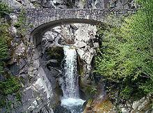 Christine Falls, one of many waterfalls visible from a short walk from the main road.
Ohanapecosh (
 /oʊˈhænəpɨkɔːʃ/) is a campground, visitor center, and ranger station located in the southeastern portion of the park, approximately 3 miles (4.8 km) from the park boundary off Highway 123. Located in a deep valley among old growth forest at an elevation below 2,000 feet (610 m), it is the only developed area of the park without a view of Mount Rainier. The Ohanapecosh Hot Springs, Grove of the Patriarchs, and Silver Falls are all located in the Ohanapecosh area.
The Carbon River Entrance Station is located in the northwest corner of the park off Highway 165 and is the site of the only rainforest at Mount Rainier. There is a campground and a short trail through the rainforest, as well as a trail to the Carbon Glacier, one of the lowest glaciers in the contiguous United States.
Mowich Lake is the largest and deepest lake in the park, located south of Carbon at the south end of Highway 165. A campground, picnic area, and hiking trail are located near the lake.
The two major roads into the northwest quadrant of the Park were severely damaged by the floods of 2006. The ranger station at the Carbon River entrance is staffed during the summer. No motor vehicles are permitted beyond that point.
References
- ^ a b Stanley Maps (2000). Mt. Rainier National Park (Map). 1 : 30,000, Cartography by Charles B. Kitterman / Kulshan Cartographic Services (Centennial ed.). ISBN 0-9662209-4-3.
- ^ http://www.nps.gov/mora/naturescience/index.htm
- ^ Bolsinger, Charles L.; Waddell, Karen L. (1993). Area of old-growth forests in California, Oregon, and Washington. United States Forest Service, Pacific Northwest Research Station. Resource Bulletin PNW-RB-197. http://www.fs.fed.us/pnw/pubs/pnw_rb197.pdf.
- ^ "Mount Rainier National Park". National Historic Landmark summary listing. National Park Service. http://tps.cr.nps.gov/nhl/detail.cfm?ResourceId=2212&ResourceType=District. Retrieved 2008-06-26.
- ^ a b c "Part One: The Cultural Setting. I. Historical Overview Of Indians And Mount Rainier". Mount Rainier Administrative History. National Park Service. 24 July 2000. http://www.nps.gov/archive/mora/adhi/adhi1.htm. Retrieved 2007-06-05.
- ^ a b Burtchard, Greg C.; with contributions by Stephen C. Hamilton and Richard H. McClure, Jr. (originally published February 1998, last updated 17 November 2004.). "Chapter 4: The 1995 Mount Rainier Archeological Reconnaissance". Environment, Prehistory & Archaeology of Mount Rainier National Park, Washington. National Park Service, Seattle, Washington; International Archaeological Research Institute, Inc.. http://www.nps.gov/archive/mora/ncrd/archaeology/chap4b.htm. Retrieved 2007-06-05.
- ^ a b c Duncan, Dayton; Ken Burns (2009). The National Parks: America's Best Idea. Random House. pp. 48–51, 84–86. ISBN 9780307268969. http://books.google.com/books?id=9lgUtQD01EAC&pg=PT48.
- ^ Carson, Rob; Craig Hill. "Rainier Timeline". The News Tribune. http://www.thenewstribune.com/2007/10/08/174139/rainier-timeline.html. Retrieved 24 July 2010.
- ^ "Chronology of Climbs on Mt. Rainier". Tacoma Public Library. http://mtn.tpl.lib.wa.us/climbs/climbing/chronology/. Retrieved 24 July 2010.
- ^ "Transcribed from "John Muir's Ascent of Mt. Rainier"". University of Washington. http://content.lib.washington.edu/warnerweb/essay.html. Retrieved 24 July 2010.
- ^ "November 2006 Flooding". Mount Rainier National Park. http://home.nps.gov/mora/parknews/november-2006-flooding.htm. Retrieved 2007-05-30.
- ^ Carlton Harrell, Debera (5 May 2007). "Battered Mt. Rainier to reopen". Seattle Post-Intelligencer. http://www.seattlepi.com/local/314551_rainier05.html. Retrieved 2007-05-22.
- ^ "National Register of Historic Places Nomination Form: Historic Resources of Mount Rainier National Park MPS". National Park Service. https://fortress.wa.gov/dahp/wisaard/documents/RN/0/1/1580.pdf. Retrieved 7 April 2011.
- ^ United States Geological Survey (1971). Mount Rainier East, Washington (Map). 1 : 24,000, 7,5 Minute Series (Topographic). ISBN 060701198X. Coordinate measured using National Geographic TOPO! Software Version 3.4.3.
- ^ Pitcher, Don (12 June 2002). Moon Handbooks Washington. Moon Handbooks (7th ed.). Avalon Travel Publishing. pp. 615–616. ISBN 1566913861.
- ^ a b "Mount Rainier National Park Visitor Study Brochure" (PDF). Visitor Services Project. National Park Service. 31 March 2003. http://www.nps.gov/mora/current/VSP.pdf. Retrieved 2007-05-22.
- ^ Barnes, Christine; Pfulghoft, Fred (Photographer); Morris, David (Photographer) (April 2002). Great Lodges of the National Parks: The Companion Book to the PBS Television Series. W W West. pp. 48–57. ISBN 0-9653924-5-7.
- ^ "Mt. Rainier National Park Centennial Timeline 1960s". Mount Rainier National Park Centennial Celebration. National Park Service. 1999. http://www.nps.gov/features/mora_cenn/sixties/sixties.htm. Retrieved 2007-05-22. "1966: The Paradise Visitor Center (in 1987 dedicated as the Henry M. Jackson Visitor Center), is opened to the public in September."
- ^ Doughton, Sandi (10 October 2008). "Paradise rediscovered — new Mount Rainier visitor center opens". Seattle Times website (Seattle Times). http://seattletimes.nwsource.com/html/localnews/2008246817_rainiervc10m.html. Retrieved 2009-07-27. "The new visitor center, at the park's premier destination, opens today."
- ^ a b
Climate
"Mount Rainier National Park - Frequently Asked Questions (U.S. National Park Service)". National Park Service. created 4 August 2005 modified 19 January 2007. http://www.nps.gov/mora/faqs.htm. Retrieved 2007-05-22.
- ^ "Annual Snowfall at Paradise 1920 to 2002" (PDF). National Park Service. 12 January 2007. http://www.nps.gov/mora/planyourvisit/upload/annual%20snowfall.pdf. Retrieved 2007-05-22.
- ^ "Mt. Baker Holds Snowfall Record, NOAA reports". NOAA. 2 August 1999. http://www.publicaffairs.noaa.gov/releases99/aug99/noaa99056.html. Retrieved 2011-09-16.
- ^ Andalkar, Amar (created December 2002, last updated April 2006). "Skiing the Cascade Volcanoes". Amar Andalkar's Ski Mountaineering and Climbing Site. http://www.skimountaineer.com/CascadeSki/CascadeSnow.html. Retrieved 2007-05-30.
- ^ "RAINIER PARADISE RNGER, WASHINGTON". NOAA. http://www.wrcc.dri.edu/cgi-bin/cliMAIN.pl?wa6898.
- ^ Filley, Bette (2002). Discovering the Wonders of the Wonderland Trail: Encircling Mount Rainier (5th edition). Dunamis House. pp. 37. ISBN 1-880405-09-1.
- ^ Scott, Kay W.; Scott, David L. (February 2002). The Complete Guide to the National Park Lodges, 3rd. Globe Pequot. pp. 193 ¬ 194. ISBN 0-7627-1197-3.
External links
 Media related to Mount Rainier National Park at Wikimedia Commons
- National Park Service site: Mount Rainier National Park
- Park map (PDF, 2 MB), provided by the National Park Service
- National Historic Landmark information
- University of Washington Libraries Digital Collections – Rainier National Park Mountain-Glacier Wonderland Photograph Album 50 photographs from a promotional album (ca. 1925) for Mount Rainier National Park depicting tourist facilities, scenic views of the mountain and surrounding parkland, and recreational activities including mountaineering.
- Mount Rainier National Park travel guide from Wikitravel
- Electronic Documents outlining the natural and cultural history of the park, including the complete Nature Notes (newsletter) series and the park's Administrative History [National Park Service]
National parks of the United States Acadia • American Samoa • Arches • Badlands • Big Bend • Biscayne • Black Canyon of the Gunnison • Bryce Canyon • Canyonlands • Capitol Reef • Carlsbad Caverns • Channel Islands • Congaree • Crater Lake • Cuyahoga Valley • Death Valley • Denali • Dry Tortugas • Everglades • Gates of the Arctic • Glacier • Glacier Bay • Grand Canyon • Grand Teton • Great Basin • Great Sand Dunes • Great Smoky Mountains • Guadalupe Mountains • Haleakalā • Hawaiʻi Volcanoes • Hot Springs • Isle Royale • Joshua Tree • Katmai • Kenai Fjords • Kings Canyon • Kobuk Valley • Lake Clark • Lassen Volcanic • Mammoth Cave • Mesa Verde • Mount Rainier • North Cascades • Olympic • Petrified Forest • Redwood • Rocky Mountain • Saguaro • Sequoia • Shenandoah • Theodore Roosevelt • Virgin Islands • Voyageurs • Wind Cave • Wrangell-St. Elias • Yellowstone • Yosemite • ZionList of National Parks of the United States (by elevation) Protected Areas of Washington Federal National ParksMount Rainier · North Cascades · Olympic
National MonumentsEbey's Landing National Historical Reserve · Fairhaven Historic District · Pioneer Square Historic District · Vancouver National Historic Reserve Historic District
National Recreation AreasNational Wildlife RefugesColumbia · Conboy Lake · Copalis · Dungeness · Flattery Rocks · Franz Lake · Grays Harbor · Julia Butler Hansen Refuge for the Columbian White-Tailed Deer · Lewis and Clark · Little Pend Oreille · McNary · Nisqually · Pierce · Protection Island · Quillayute Needles · Ridgefield · Saddle Mountain · San Juan Islands · Steigerwald Lake · Toppenish · Turnbull · Umatilla · Willapa
National WildernessAlpine Lakes · Boulder River · Brothers · Buckhorn · Clearwater · Colonel Bob · Glacier Peak · Glacier View · Goat Rocks · Henry M. Jackson · Indian Heaven · Juniper Dunes · Lake Chelan-Sawtooth Ridge · Mount Adams · Mount Baker · Mount Rainier · Mount Skokomish · Noisy-Diobsud · Norse Peak · Olympic · Pasayten · Salmo-Priest · San Juan · Stephen Mather · Tatoosh · Trapper Creek · Washington Islands · Wenaha–Tucannon · Wild Sky · William O. Douglas · Wonder Mountain
State Alta Lake · Anderson Lake · Battle Ground Lake · Bay View · Beacon Rock · Belfair · Birch Bay · Blake Island · Blind Island · Bogachiel · Bottle Beach · Bridgeport · Bridle Trails · Brooks Memorial · Cama Beach · Camano Island · Camp Wooten Environmental Learning Center · Cape Disappointment · Centennial Trail · Clark Island · Columbia Hills · Columbia Plateau Trail · Conconully · Crawford · Curlew Lake · Cutts Island · Damon Point · Daroga · Dash Point · Deception Pass · Dosewallips · Doug's Beach · Eagle Island · Fay Bainbridge · Federation Forest · Fields Spring · Flaming Geyser · Fort Casey · Fort Columbia · Fort Ebey · Fort Flagler · Fort Okanogan · Fort Simcoe · Fort Townsend · Fort Ward · Fort Worden · Ginkgo Petrified Forest · Goldendale Observatory · Grayland Beach · Griffin Bay · Griffiths-Priday · Harstine Island · Hope Island (Mason County) · Hope Island (Skagit County) · Ike Kinswa · Illahee · Iron Horse · James Island · Jarrell Cove · Joemma Beach · Jones Island · Joseph Whidbey · Kanaskat-Palmer · Kinney Point · Kitsap Memorial · Kopachuck · Lake Chelan · Lake Easton · Lake Sammamish · Lake Sylvia · Lake Wenatchee · Larrabee · Leadbetter Point · Lewis and Clark · Lewis and Clark Trail · Lime Kiln Point · Lincoln Rock · Manchester · Maryhill · Matia Island · McMicken Island · Millersylvania · Moran · Mount Pilchuck · Mount Spokane · Mystery Bay · Nine Mile Recreation Area · Nolte · Ocean City · Olallie · Olmstead Place · Osoyoos Lake · Pacific Beach · Pacific Pines · Palouse Falls · Paradise Point · Patos Island · Peace Arch · Pearrygin Lake · Penrose Point · Peshastin Pinnacles · Pleasant Harbor · Posey Island · Potholes · Potlatch · Rainbow Falls · Rasar · Reed Island · Riverside · Rockport · Sacajawea · Saint Edward · Saltwater · Scenic Beach · Schafer · Seaquest · Sequim Bay · Shine Tidelands · Skagit Island · Skull Island · South Whidbey · Spencer Spit · Squak Mountain · Squilchuck · Steamboat Rock · Steptoe Battlefield · Steptoe Butte · Stretch Point · Stuart Island · Sucia Island · Sun Lakes · Tolmie · Triton Cove · Turn Island · Twanoh · Twenty-Five Mile Creek · Twin Harbors · Upright Channel · Wallace Falls · Wanapum Recreational Area · Wenatchee Confluence · Westport Light · Yakima Sportsman
Ahtanum · Capitol · Elbe Hills · Green Mountain · Loomis · Loup Loup · Tahoma · Tahuya · Tiger Mountain · Yacolt Burn
Admiralty Inlet · Badger Gulch · Bald Hill · Barker Mountain · Bone River · Camas Meadows · Carlisle Bog · Castle Rock · Charley Creek · Chehalis River Surge Plain · Chopaka Mountain · Clearwater Bogs · Cleveland Shrub Steppe · Columbia Falls · Columbia Hills · Cypress Highlands · Dabob Bay · Dailey Prairie · Davis Canyon · Entiat Slopes · Goose Island · Gunpowder Island · Kahlotus Ridgetop · Kennedy Creek · Kings Lake Bog · Kitsap Forest · Little Pend Oreille River · Marcellus Shrub Steppe · Methow Rapids · Mima Mounds · Monte Cristo · Niawiakum River · North Bay · Oak Patch · Olivine Bridge · Pinecroft · Point Doughty · Riverside Breaks · Rocky Prairie · Sand Island · Schumacher Creek · Selah Cliffs · Skagit Bald Eagle · Skookum Inlet · Snoqualmie Bog · Spring Creek Canyon · Trout Lake · The Two-Steppe · Upper Dry Gulch · Washougal Oaks Natural Area · Whitcomb Flats · Willapa Divide
Cattle Point · Clearwater Corridor · Cypress Island · Devils Lake · Dishman Hills · Elk River · Ellsworth Creek · Granite Lakes · Hat Island · Hendrickson Canyon · Klickitat Canyon · Lake Louise · Loomis · Lummi Island · Merrill Lake · Morning Star · Mount Si · Rattlesnake Mountain Scenic Area · Shipwreck Point · South Nemah · South Nolan · Stavis · Table Mountain · Tahoma Forest · Teal Slough · Washougal Oaks Natural Area · West Tiger Mountain · White Salmon Oak · Woodard Bay
Other Former state parksLyons Ferry Park · Mukilteo Lighthouse Park · Wenberg County Park
Blanchard Forest · Cascadia Marine Trail · The Enchantments · Goose Island · Sehome Hill Arboretum · Withrow Moraine · Yellow Island
National Register of Historic Places in Mount Rainier National Park National Historic Landmarks - Longmire Buildings
- Paradise Inn
National Historic Landmark District - Mount Rainier National Park
- Yakima Park Stockade Group
Other historic districts - Longmire Historic District
- Nisqually Entrance Historic District
- Paradise Historic District
- Sunrise Historic District
- White River Entrance
Other properties - Camp Muir
- Chinook Pass Entrance Arch
- Christine Falls Bridge
- Edith Creek Chlorination House
- Gobbler's Knob Fire Lookout
- Huckleberry Creek Patrol Cabin
- Indian Bar Trail Shelter
- Indian Henry's Patrol Cabin
- Ipsut Creek Patrol Cabin
- Lake George Patrol Cabin
- Longmire Campground Comfort Station No. L-302
- Longmire Campground Comfort Station No. L-303
- Longmire Campground Comfort Station No. L-304
- Mt. Fremont Fire Lookout
- Mowich Lake Patrol Cabin
- Narada Falls Bridge
- Narada Falls Comfort Station
- North Mowich Trail Shelter
- Shriner Peak Fire Lookout
- South Puyallup River Bridge
- St. Andrews Creek Bridge
- St. Andrews Patrol Cabin
- Summerland Trail Shelter
- Sunrise Comfort Station
- Sunset Park Patrol Cabin
- Sunset Park Trail Shelter
- Tahoma Vista Comfort Station
- Three Lakes Patrol Cabin
- Tipsoo Lake Comfort Station
- Tolmie Peak Fire Lookout
- White River Bridge
- White River Mess Hall and Dormitory
- White River Patrol Cabin
See also: National Register of Historic Places listings in Mount Rainier National Park U.S. National Register of Historic Places Topics Lists by states Alabama • Alaska • Arizona • Arkansas • California • Colorado • Connecticut • Delaware • Florida • Georgia • Hawaii • Idaho • Illinois • Indiana • Iowa • Kansas • Kentucky • Louisiana • Maine • Maryland • Massachusetts • Michigan • Minnesota • Mississippi • Missouri • Montana • Nebraska • Nevada • New Hampshire • New Jersey • New Mexico • New York • North Carolina • North Dakota • Ohio • Oklahoma • Oregon • Pennsylvania • Rhode Island • South Carolina • South Dakota • Tennessee • Texas • Utah • Vermont • Virginia • Washington • West Virginia • Wisconsin • WyomingLists by territories Lists by associated states Other  Category:National Register of Historic Places •
  Portal:National Register of Historic Places
Waterfalls in or near Mount Rainier National Park of Washington Bloucher • Carter • Chinook Creek • Christine • Comet • Deer Creek • Fairy • Faraway • Fish Ladder • Golden Gate • Kautz Creek • Little Mashel • Mowich Glacier• Narada • Ohanapecosh • Paradise River • Pearl • Silver • Snoquera • Sydney • Thunder • Upper Comet • Upper Stevens Creek • Van Trump • Wilson Glacier •
Categories:- IUCN Category II
- Protected areas established in 1899
- Archaeological sites in Washington (state)
- National Historic Landmarks in Washington (state)
- Old growth forests
- Mount Rainier National Park
- Native American archeology
- Parks in Lewis County, Washington
- Parks in Pierce County, Washington
Wikimedia Foundation. 2010.


