- Nisqually River
-
Nisqually River River 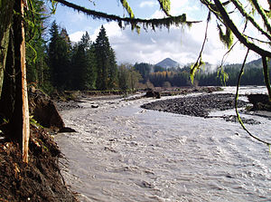 Nisqually River near Ashford during a flood in 2006 that destroyed a campground in Mount Rainier National Park.
Country United States State Washington Districts Nisqually Indian Reservation, Fort Lewis Tributaries - left Little Nisqually River - right Mashel River Source Nisqually Glacier - location Mount Rainier - elevation 4,809 ft (1,466 m) [1] - coordinates 46°47′39″N 121°44′54″W / 46.79417°N 121.74833°W [2] Mouth Puget Sound - location Nisqually National Wildlife Refuge - elevation 0 ft (0 m) - coordinates 47°6′31″N 122°42′11″W / 47.10861°N 122.70306°W [2] Length 81 mi (130 km) Basin 517 sq mi (1,339 km2) [3] Discharge for La Grande, WA - average 1,460 cu ft/s (41 m3/s) [4] - max 39,500 cu ft/s (1,119 m3/s) - min 460 cu ft/s (13 m3/s) 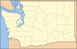
 Mouth of the Nisqually River in Washington
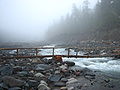
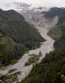 Near its source in Mount Rainier National Park, the Nisqually River flows under a bridge of Route 706.
The Nisqually River (
 /nɪˈskwɑːli/) is a river in west central Washington in the United States, approximately 81 miles (130 km) long. It drains part of the Cascade Range southwest of Tacoma, including the southern slope of Mount Rainier, and empties into the southern end of Puget Sound.
The Nisqually River forms the Pierce-Lewis county line, as well as the boundary between Pierce and Thurston counties.
Contents
Course
The river rises in southern Mount Rainier National Park, fed by the Nisqually Glacier on the southern side of Mt. Rainier. It flows west through Ashford and Elbe along Route 706. It is then impounded for hydroelectricity by the Alder Dam, completed in 1944, and the La Grande Dam, completed in 1912 and rebuilt in 1945. They hold back Alder Reservoir and La Grande Reservoir. Before the construction of the dams, a natural fish barrier prevented anadromous fish from ascending the Nisqually above what is now La Grande Reservoir.[5]
Below Elbe, the river flows northwest through the foothills, passes near McKenna, Washington, and through Fort Lewis and the Nisqually Indian Reservation. The river crosses beneath Interstate 5 and into the Nisqually River Delta, which is the location of the Nisqually National Wildlife Refuge. The Nisqually enters the Nisqually Reach portion of Puget Sound approximately 15 miles (24 km) east of Olympia.
History
The Nisqually River is the traditional territorial center of the Nisqually tribe that shares its name and also lived throughout southern Puget Sound. The Treaty of Medicine Creek, one of the major Northwest treaties between Washington territory and the native population of Puget Sound, was signed near a creek at the site of what is now a wildlife refuge near the delta of the river. The Nisqually were moved from the river and much of the surrounding region after the signing of the treaty, settling on a reservation on Puget Sound east of Olympia. After a period of resistance by the Nisqually tribe, including such leaders as Chief Leschi, a new reservation three times the size of the original was established on the river.
In 1917, the US Army occupied the Nisqually reservation, ordered people from their homes, and later condemned most of the reservation to build Fort Lewis.[6]
In the 1960s and 1970s, the Nisqually pursued their fishing rights along the river, which were stated in the Treaty of Medicine Creek but had been ignored. Nisqually tribal members, acting in concert with the nearby Puyallup tribe, endured harassment and arrest to fish in traditional waters. This led to the 1974 Boldt Decision that granted all native tribes in Washington state the right to 50% of the fish within their traditional territories.
Ecology
"Nisqually-1", a specimen of Populus trichocarpa, grew on the bank of the Nisqually River. Its genome sequence was published in 2006.
Tributaries
- Van Trump Creek
- Paradise River
- Muck Creek
- Yelm Creek
- Tanwax Creek
- Ohop Creek
- Mashel River
- Little Nisqually River
- East Creek
- Mineral Creek
- Big Creek
- Kautz Creek
Cities and towns on the Nisqually
-

Mount Rainier and headwaters of the river from the Nisqually Glacier
-

Alder Dam near Elbe, Washington
-
The upper Nisqually River in Mount Rainier National Park
-

I-5 crosses the Nisqually River near its mouth
See also
- List of rivers in Washington
References
- ^ Google Earth elevation for GNIS source coordinates. Retrieved April 20, 2007.
- ^ a b United States Geological Survey; U.S. Geological Survey Geographic Names Information System: Nisqually River; retrieved April 20, 2007.
- ^ United States Geological Survey; Nisqually River at McKenna, WA; retrieved April 20, 2007.
- ^ United States Geological Survey; Nisqually River at La Grande, WA; retrieved April 20, 2007 (used instead of McKenna gage due to power canal river diversion).
- ^ "Nisqually River Project". Tacoma Power. http://www.ci.tacoma.wa.us/Power/parksandpower/fish_wildlife/nisqually_river_project.htm. Retrieved 2009-05-20.
- ^ Nisqually (tribe); Nisqually Indian Tribe - History; retrieved on May 7, 2007.
External links
- Nisqually River Council
- Nisqually Land Trust
- Nisqually River flooding information, Thurston County Emergency Management
Categories:- Rivers of Washington (state)
- Landforms of Lewis County, Washington
- Landforms of Pierce County, Washington
- Landforms of Thurston County, Washington


Wikimedia Foundation. 2010.