- United States National Marine Sanctuary
-
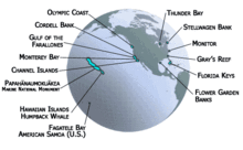
A U.S. National Marine Sanctuary is a federally-designated area within United States waters that protects areas of the marine environment with special conservation, recreational, ecological, historical, cultural, archeological, scientific, educational, or aesthetic qualities. The National Marine Sanctuary System consists of 14 marine protected areas that encompass more than 150,000 square miles (390,000 km2). Individual areas range from less than 1 to 137,792 square miles.[1]
The National Marine Sanctuaries Program (NMSP), a division of the National Oceanic and Atmospheric Administration (NOAA) administers the 13 national marine sanctuaries. The Northwestern Hawaiian Islands Marine National Monument is a marine protected area but not a national marine sanctuary.[1] The program began after the 1969 Santa Barbara oil spill off the coast of California brought the plight of marine ecosystems to national attention. The United States Congress responded in 1972 with the Marine Protection, Research and Sanctuaries Act which allowed for the creation of marine sanctuaries. The resources protected by U.S. national marine sanctuaries range from coral reef ecosystems in Florida, Hawaii, and American Samoa to shipwrecks in Lake Huron and the wreck of the USS Monitor. The Papahānaumokuākea Marine National Monument, while not a U.S. national marine sanctuary, is also jointly administered by the NMSP, in conjunction with the U.S. Fish and Wildlife Service and the State of Hawaii.
List of U.S. National Marine Sanctuaries
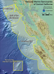
 Diagram illustrating the orientation of the 3 marine sanctuaries of Central California: Cordell Bank, Gulf of the Farallones, and Monterey Bay.
- Channel Islands National Marine Sanctuary (Pacific)
- Cordell Bank National Marine Sanctuary (Pacific)
- Fagatele Bay National Marine Sanctuary (Pacific)
- Florida Keys National Marine Sanctuary (Atlantic, Gulf Coast)
- Flower Garden Banks National Marine Sanctuary (Gulf Coast)
- Gray's Reef National Marine Sanctuary (Atlantic)
- Gulf of the Farallones National Marine Sanctuary (Pacific)
- Hawaiian Islands Humpback Whale National Marine Sanctuary (Pacific)
- Monitor National Marine Sanctuary (Atlantic)
- Monterey Bay National Marine Sanctuary (Pacific)
- Olympic Coast National Marine Sanctuary (Pacific)
- Stellwagen Bank National Marine Sanctuary (Atlantic)
- Thunder Bay National Marine Sanctuary (Great Lakes)
- Papahānaumokuākea Marine National Monument (Pacific)
Notes
External links
Categories:- National Marine Sanctuaries of the United States
- Protected areas of the United States
- United States stubs
Wikimedia Foundation. 2010.


