- Emmons Glacier
Infobox_Glacier | glacier_name = Emmons Glacier
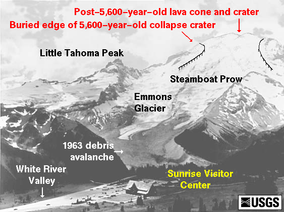
caption = Illustration of area around Emmons Glacier
type = Mountain glacier
location =Washington , U.S.
coordinates = coord|46|51|46|N|121|42|59|W|type:glacier
area = 4.3 square miles (11 km²) (as of 1983)Cite web|title= DESCRIPTION: Mount Rainier Glaciers and Glaciations - Mount Rainier Glacier Hazards and Glacial Outburst Floods|url=http://vulcan.wr.usgs.gov/Volcanoes/Rainier/Glaciers/description_rainier_glaciers.html|accessdate= 2007-11-19|publisher=USGS]
length = 4.5 miles (7.2 km) est.
thickness =
terminus = Moraine
status = RetreatingEmmons Glacier is a
glacier on the northeast flank ofMount Rainier , inWashington . At 4.3 square miles (11 km²), it has the largest surface area of any glacier in thecontiguous United States . The glacier was named after the geologistSamuel Franklin Emmons after his involvement in a survey of Mount Rainier in 1870.Starting at an elevation of over Convert|13800|ft|m|-2, the Emmons glacier flows down eastward. Near the Disappointment Cleaver at Convert|12200|ft|m|-2, the Emmons is joined by the Ingraham Glacier flowing to the south. The glaciers flow together and remain connected until they split up upon reaching the wedge of
Little Tahoma Peak . As the Emmons flows northeast, the massive glacier descends until it reaches its rocky lower terminus at about Convert|5100|ft|m|-2 in elevation. [Cite web|url=http://www.topoquest.com/map.php?lat=46.86459&lon=-121.72040&datum=nad27&zoom=8|title=TopoQuest topographic map|accessdate=2008-05-15|abbr=on|abbr=on|abbr=on]In the 1930s, the glacier was found to be receding quickly. However, in 1963, a rock fall from Little Tahoma Peak covered the lower glacier with rock debris. The debris cover insulated the ice from melting. As a result of decreased melting, the glacier advanced rapidly in the early 1980s. That advance was continuing as of 1992, but at a slower rate; ice beneath the rock debris was melting irregularly and forming a vast hummocky area. [cite paper
author = Driedger, Carolyn L.
title = Glaciers on Mount Rainier
version = Open-File Report 92-474
publisher = US Geological Survey
date = 1992/1993
url = http://vulcan.wr.usgs.gov/Volcanoes/Rainier/Publications/OFR92-474/OFR92-474.html
accessdate = 2006-12-31 ] By 2003, the glacier was again retreating. ["Inthe past few decades the glaciers [in the American West] have been receding,continuing a trend from the Little Ice Age." cite conference
last = Fountain
first = Andrew G.
coauthors = Percy, David; Granshaw, Frank
title = Glaciers of the American West
booktitle = Geological Society of America 2003 Seattle Annual Meeting
date =2003-11-02
url = http://gsa.confex.com/gsa/2003AM/finalprogram/abstract_67665.htm
accessdate = 2006-12-31 ]Emmons Glacier is often used as a route (the Columbia Crest route) to climb to the summit of Mount Rainier.
ee also
*
List of glaciers References
Wikimedia Foundation. 2010.