- Ohanapecosh Glacier
-
Ohanapecosh Glacier 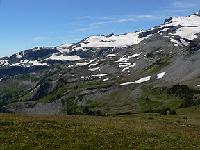
View SSW from Banshee PeakType Mountain glacier Location Mount Rainier, Pierce County, Washington, USA Coordinates 46°50′09″N 121°40′12″W / 46.8359426°N 121.6700934°W[1] Area 0.6 square miles (1.6 km2), 1983[2] The Ohanapecosh Glacier is small glacier located on Mount Rainier's southeastern flanks in Washington. It covers 0.6 square miles (1.6 km2) and contains 1.3 billion ft3 (37 million m3) of ice.[2] The glacier consists of several lobes of ice interconnected by thin snowfields. Most of the glacier lies at an elevation of 8,300 feet (2,500 m) to 7,400 feet (2,300 m), near the Whitman and the Fryingpan Glacier.[3] Since this ice lobe ends on a cliff, it contributes ice to the lower portions of the Ohanapecosh Glacier. The lower sections of this glacier end on cliffs and a small valley at about 6,100 ft (1,900 m) in elevation.[3] Meltwater from the glacier drains into the Ohanapecosh River and the Muddy Fork Cowlitz River, which merge downstream about four miles (6 km) outside of Mount Rainier National Park into the Cowlitz River.[2]
See also
References
- ^ "Ohanapecosh Glacier". Geographic Names Information System, U.S. Geological Survey. http://geonames.usgs.gov/pls/gnispublic/f?p=gnispq:3:::NO::P3_FID:1533600.
- ^ a b c "DESCRIPTION: Mount Rainier Glaciers and Glaciations - Mount Rainier Glacier Hazards and Glacial Outburst Floods". USGS. http://vulcan.wr.usgs.gov/Volcanoes/Rainier/Glaciers/description_rainier_glaciers.html. Retrieved 2007-11-19.
- ^ a b "Ohanapecosh Glacier, USGS Mount Rainier East (WA) Topo Map". USGS Quad maps. TopoQuest.com. http://www.topoquest.com/map.php?lat=46.83643&lon=-121.66777&datum=nad27&zoom=4. Retrieved 2008-05-17.
Glaciers of Mount Rainier Mount Rainier Carbon Glacier · Cowlitz Glacier · Edmunds Glacier · Emmons Glacier · Flett Glacier · Fryingpan Glacier · Ingraham Glacier · Inter Glacier · Kautz Glacier · Liberty Cap Glacier · Nisqually Glacier · North Mowich Glacier · Ohanapecosh Glacier · Paradise Glacier · Puyallup Glacier · Pyramid Glacier · Russell Glacier · South Mowich Glacier · South Tahoma Glacier · Success Glacier · Tahoma Glacier · Van Trump Glacier · Whitman Glacier · Wilson Glacier · Williwakas Glacier · Winthrop GlacierSee also Glaciers of Mount Adams · Glaciers of Mount Baker · Glaciers of Glacier Peak · Glaciers of the Olympic Mountains · Glaciers of other Washington mountainsCategories:- Glaciers of Mount Rainier

Wikimedia Foundation. 2010.