- White River (Washington)
Geobox River
name = White River
native_name =
other_name = Stuck River
other_name1 =
image_size = 300 px
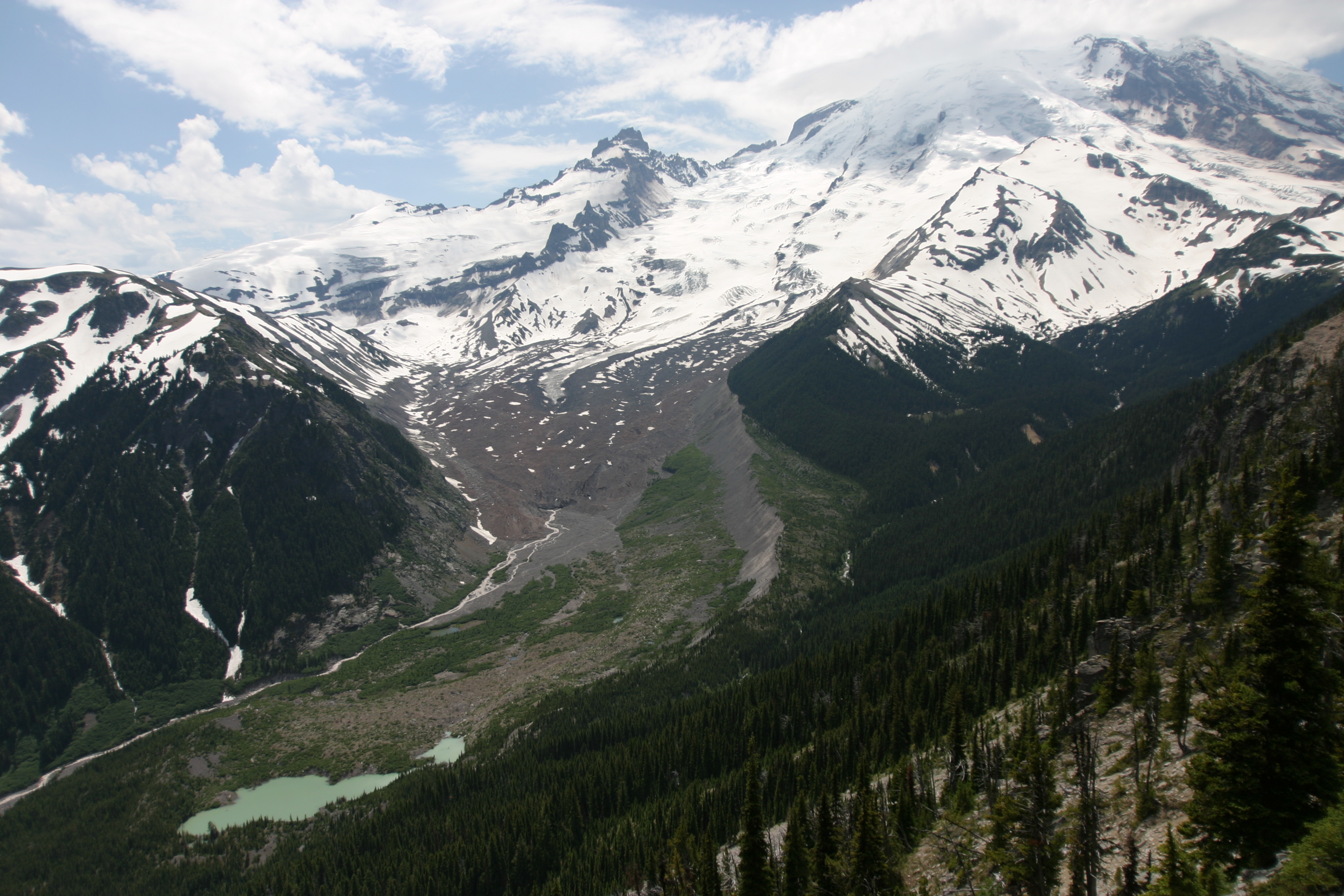
image_caption = The headwaters of the White River at Emmons Glacier
country = United States
country1 =
state = Washington
state1 =
region_type = Counties
region = Pierce
region1 = King
district =
district1 =
city = Buckley
city1 =
length_imperial = 75
length_note = [http://www.bartleby.com/69/92/W02892.html White River] , The Columbia Gazetteer of North America]
watershed_imperial = 494
watershed_note = [http://dnr.metrokc.gov/wlr/watersheds/white/Whiterivfacts.HTM White River Watershed Facts] , King County.]
discharge_location = Buckley
discharge_imperial = 1435
discharge_max_imperial = 17000
discharge_min_imperial = 59
discharge_note = [http://pubs.usgs.gov/wdr/2005/wdr-wa-05-1/pdf/wa00103ADR2005_Figure28.pdf Puyallup and White River Basins] , Water Resource Data, Washington, 2005, USGS.]
discharge1_location =
discharge1_imperial =
source_name = Mount Rainier
source_location = Emmons Glacier
source_district =
source_region =
source_state =
source_country =
source_lat_d = 46
source_lat_m = 53
source_lat_s = 7
source_lat_NS = N
source_long_d = 121
source_long_m = 40
source_long_s = 24
source_long_EW = W
source_coordinates_note = gnis|1528078]
source_elevation_imperial = 5050
source_elevation_note =Google Earth elevation for GNIS coordinates.]
source_length_imperial =
mouth_name = Puyallup River
mouth_location =
mouth_district =
mouth_region =
mouth_state =
mouth_country =
mouth_lat_d = 47
mouth_lat_m = 11
mouth_lat_s = 59
mouth_lat_NS = N
mouth_long_d = 122
mouth_long_m = 15
mouth_long_s = 31
mouth_long_EW = W
mouth_coordinates_note =
mouth_elevation_imperial = 29
mouth_elevation_note =
tributary_left =West Fork White River
tributary_left1 = Clearwater River
tributary_right = Greenwater River
tributary_right1 =
free_name =
free_value =
map_size =
map_caption = The White River is ariver in theU.S. state ofWashington . It flows about 75 miles (121 km) from its source, theEmmons Glacier onMount Rainier , to join thePuyallup River at Sumner. It defines part of the boundary between King and Pierce counties.Course
The source of the White River is the Emmons Glacier on the northeast side of Mount Rainier. The river flows from ice caves at the toe of the glacier. Its upper reach is contained within
Mount Rainier National Park . Shortly after emerging from the Emmons Glacier, the White River flows generally east, by the White River Campground, then the White River Ranger Station, after which it turns north. The river is paralled by much of its upper course by State Route 410, called the Mather Memorial Parkway in the national park. After several miles the river exits Mount Rainier National Park and entersMount Baker-Snoqualmie National Forest .The river turns gradually westward, passing several national forest campgrounds. Huckleberry Creek joins just below The Dalles Campground. Several miles downriver from there the White River is joined by one of its main tributaries, the West Fork White River, which also originates at a glacier in Mount Rainier National Park, in this case,
Winthrop Glacier . A few miles downriver from the West Fork confluence another major tributary joins, theGreenwater River . The small settlement of Greenwater is located at the confluence.Below Greenwater, the White River flows generally west. It passes
Federation Forest State Park and is then joined by another tributary, the Clearwater River. Several miles downriver from there the White River is impounded by Mud Mountain Dam, which creates a marshy intermittent lake called Mud Mountain Lake. The dam was built for flood control purposes. Mud Mountain Lake only fills with water during conditions of exceptionally high streamflow.Below Mud Mountain Dam the White River enters the greater Tacoma metropolitan area. It flows between the cities of Buckley and Enumclaw, after which it makes a large bend northwest and then southwest, essentially flowing around Lake Tapps. North of the lake, the White River flows through the Muckleshoot Indian Reservation. Below that, to the west of Lake Tapps, the White River enters a broad
floodplain and flows past the city of Pacific before emptying into the Puyallup River at Sumner.Lake Tapps is a reservoir created in 1911 for hydroelectric purposes. A diversion dam near Buckley taps the White River's water, sending a portion of it through a flume, a canal, and a pipeline to Lake Tapps. An outlet canal on the west side of the lake routes water through the turbines of the Dieringer Powerhouse, after which the water is returned to the White River. [General course info from cite book | title = Washington Road & Recreation Atlas | year = 2000 | publisher =
Benchmark Maps ]River modifications
Before 1906, the White River joined the Green River near Auburn, and the combined river (under the name "White") joined the Black River at Tukwila, forming the
Duwamish River , which emptied intoElliott Bay atSeattle . In 1906, a great flood coupled with a large log and debris jam diverted the White River southward into the Stuck River thence into the Puyallup River, which empties intoCommencement Bay at Tacoma. Thedebris dam was replaced with a permanent diversion wall. Thus the White River remains a tributary of the Puyallup River today.In the late 19th century farmers along the White River were subjected to nearly annual floods. Sometimes farmers would use dynamite to divert the river into different channels. In 1899 one such explosion went awry and ended up diverting most of the White River into the Stuck River, thence the Puyallup. Dynamiting the river channels continued until the major flood of 1906 which ended up sending the entire White River down the Stuck River. Due to the risk of floods, the diversion was not wanted by Pierce County, which sued King County in an attempt to have the White River rediverted away from the Stuck River. The lawsuit dragged on for years until 1913 when the two counties reached an agreement. Pierce County would keep the White River, but King County would pay 60% of the cost of flood control. Dams, levees, and barriers were built along the White River in hopes of preventing major flooding, but in 1933 a large flood inundated the region. The two counties realized they were unable to tame the river and so turned to the federal government. The result was Mud Mountain Dam. [http://www.historylink.org/essays/output.cfm?file_id=3584 Mud Mountain Dam] , HistoryLink.]
Mud Mountain Dam, built by the
United States Army Corps of Engineers for flood control purposes, was completed in 1948. The dam blocks anadromous fish passage, so a "trap and haul" system is used, in which fish are transported around the dam by truck. After Mud Mountain Dam was built, the farmers of the lower White River were freed from the previously near-constant worry about flooding.In 1911 a diversion dam was built near Buckley which, along with a system of dikes around the originally small Lake Tapps created a larger reservoir. Over the years a small community has developed around the lake. The reservoir's water is returned to the White River about 20 miles downstream from the diversion dam. Ownership and operation was transferred to
Puget Sound Energy . Recently, Puget Sound Energy has considered shutting down the project as unprofitable. Local residents have organized efforts to maintain the lake as it is even if Puget Sound Energy leaves.Several miles upriver from the Lake Tapps diversion dam the White River is impounded by Mud Mountain Dam, for flood control purposes.
Natural history
The White River and its tributaries provide habitat for salmon species including Chinook, Pink, Chum, and
Coho salmon , as well as Rainbow, Steelhead, andCutthroat trout . Pink and Chum salmon dominate the runs. The White River Coho salmon are a mixed population of hatchery and wild fish. The native White River spring Chinook salmon are listed as threatened under theEndangered Species Act .History
The White River valley was the scene of violent clashes between Native Americans and the militias of
Washington Territory as well as the U.S. Army during thePuget Sound War of 1855-1856.ee also
*
List of Washington rivers References
External links
* [http://www.wrvmuseum.org/journal/journal_0403.htm White River Journal: Flooding, Dams, and Renamed Rivers]
*
Wikimedia Foundation. 2010.