- Tiger Mountain
-
Tiger Mountain 
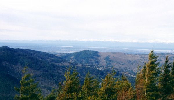
Squak Mountain, Cougar Mountain, and Seattle seen from the summit of West Tiger #3Elevation 3,004 ft (916 m) NAVD 88[1] Prominence 1,644 ft (501 m) [2] Location Location King County, Washington, USA Range Issaquah Alps Coordinates 47°29′17″N 121°56′49″W / 47.488096836°N 121.946962119°WCoordinates: 47°29′17″N 121°56′49″W / 47.488096836°N 121.946962119°W[1] Topo map USGS Hobart Tiger Mountain is a mountain in the U.S. state of Washington.
Contents
The mountain
The mountain has six peaks in the center of the Issaquah Alps forming a 13,500-acre (55 km2) triangle between Interstate 90 (I-90) on the north, the Issaquah-Hobart Road on the southwest, and State Route 18 (SR 18) on the southeast. Immediately to the west is Squak Mountain followed by Cougar Mountain, to the south east are Mc Donald and Taylor Mountains, and Rattlesnake Ridge.
It was established as Tiger Mountain State Forest in 1981. In 1989, the entire Issaquah Plateau in the northwest corner was designated as a conservation area, the West Tiger Mountain Natural Resources Conservation Area, accessed by a large trailhead at Exit 20 on I-90.
The most crowded trail leads to the bald summit of West Tiger #3, with a panoramic view of Seattle and points to the south and east. It is a 6.2-mile (10.0 km) hike, round-trip, with an elevation change of about 2,000 feet (610 m). The nearby peaks of West Tiger #2 and West Tiger #1 provide essentially the same view, but with fewer obstructions the higher one goes.
Poo Poo Point, a bare shoulder of West Tiger Mountain, is a bare ridge on the west side of Tiger Mountain. The point is named for the sound the steam whistles would make when signaling loggers. The point is a popular launching point for paragliding and hang gliding. You can reach the point by the Chirico Trail which starts at the landing zone for the hang gliders and paragliders in a field adjacent to the Issaquah-Hobart Road, or by taking the High School Trail which begins on 2nd Avenue just south of Issaquah High School. Many people fly year-round (weather permitting) and have flown cross-country flights exceeding 75 miles (121 km).[3]
State Route 18 bypasses the congested highways of the metro Seattle area. It reaches an elevation of 1,375 feet (419 m) between Tiger and Taylor Mountain, where another major trailhead is located. This provides access to South Tiger Mountain with limited views, Middle Tiger Mountain with a 45 degree window looking down on the Cedar Hills Landfill, and East Tiger Mountain with a panoramic view south toward Mount Rainier.
Many trails on Tiger Mountain have wide beds and slope very gently because they are built on the remnants of 1920s logging railroads, long after the rails and crossties were salvaged in the Great Depression. Near Middle Tiger Mountain is the site of a fatal 1924 train wreck where artifacts can still be seen.
In the most remote part of the forest, 15 Mile Creek arises in the pass between East and West Tiger. The creek carves a miniature "Grand Canyon" through sandstone.
Much of Tiger Mountain is owned or managed by the Washington State Department of Natural Resources.[4]
Sources
- Zilly, John (2003). Beyond Mount Si: the best hikes within 85 miles of Seattle. Seattle: Adventure Press. ISBN 1881583082.
References
- ^ a b "Tiger Mtn". NGS data sheet. U.S. National Geodetic Survey. http://www.ngs.noaa.gov/cgi-bin/ds_mark.prl?PidBox=SX1409.
- ^ "Tiger Mountain, Washington". Peakbagger.com. http://www.peakbagger.com/peak.aspx?pid=2208.
- ^ "Tiger Mountain site guide.". Cloudbase Country Club.. http://www.cloudbase.org/Flying/SiteGuide/TigerMountainWA/tabid/87/Default.aspx. Retrieved 2008-09-20.
- ^ "Washington State Department of Natural Resources". Washington State Department of Natural Resources. http://www.dnr.wa.gov/Pages/default.aspx. Retrieved 2008-09-22.
External links
- Hiking Snoqualmie "Granite Mountain Lookout". Hiking Snoqualmie. http://hikingsnoqualmie.blogspot.com Hiking Snoqualmie.
- "Grand Ridge Trail - High Point Trailhead". HikingWithMyBrother.com. http://www.hikingwithmybrother.com/search?q=%22Tiger+Mountain%22.
- "Tiger Mountain". SummitPost.org. http://www.summitpost.org/page/222276.
- "Tiger Mountain, Hobart, WA". Washington Horse Trails. Trail Meister. http://www.trailmeister.com/Washington/TigerSouth/Tiger.htm.
- "Tiger Mountain". Geographic Names Information System, U.S. Geological Survey. http://geonames.usgs.gov/pls/gnispublic/f?p=gnispq:3:::NO::P3_FID:1527215.
Protected Areas of Washington Federal National ParksNational MonumentsEbey's Landing National Historical Reserve · Fairhaven Historic District · Pioneer Square Historic District · Vancouver National Historic Reserve Historic District
National Recreation AreasNational Wildlife RefugesColumbia · Conboy Lake · Copalis · Dungeness · Flattery Rocks · Franz Lake · Grays Harbor · Julia Butler Hansen Refuge for the Columbian White-Tailed Deer · Lewis and Clark · Little Pend Oreille · McNary · Nisqually · Pierce · Protection Island · Quillayute Needles · Ridgefield · Saddle Mountain · San Juan Islands · Steigerwald Lake · Toppenish · Turnbull · Umatilla · Willapa
National WildernessAlpine Lakes · Boulder River · Brothers · Buckhorn · Clearwater · Colonel Bob · Glacier Peak · Glacier View · Goat Rocks · Henry M. Jackson · Indian Heaven · Juniper Dunes · Lake Chelan-Sawtooth Ridge · Mount Adams · Mount Baker · Mount Rainier · Mount Skokomish · Noisy-Diobsud · Norse Peak · Olympic · Pasayten · Salmo-Priest · San Juan · Stephen Mather · Tatoosh · Trapper Creek · Washington Islands · Wenaha–Tucannon · Wild Sky · William O. Douglas · Wonder Mountain
State Alta Lake · Anderson Lake · Battle Ground Lake · Bay View · Beacon Rock · Belfair · Birch Bay · Blake Island · Blind Island · Bogachiel · Bottle Beach · Bridgeport · Bridle Trails · Brooks Memorial · Cama Beach · Camano Island · Camp Wooten Environmental Learning Center · Cape Disappointment · Centennial Trail · Clark Island · Columbia Hills · Columbia Plateau Trail · Conconully · Crawford · Curlew Lake · Cutts Island · Damon Point · Daroga · Dash Point · Deception Pass · Dosewallips · Doug's Beach · Eagle Island · Fay Bainbridge · Federation Forest · Fields Spring · Flaming Geyser · Fort Casey · Fort Columbia · Fort Ebey · Fort Flagler · Fort Okanogan · Fort Simcoe · Fort Townsend · Fort Ward · Fort Worden · Ginkgo Petrified Forest · Goldendale Observatory · Grayland Beach · Griffin Bay · Griffiths-Priday · Harstine Island · Hope Island (Mason County) · Hope Island (Skagit County) · Ike Kinswa · Illahee · Iron Horse · James Island · Jarrell Cove · Joemma Beach · Jones Island · Joseph Whidbey · Kanaskat-Palmer · Kinney Point · Kitsap Memorial · Kopachuck · Lake Chelan · Lake Easton · Lake Sammamish · Lake Sylvia · Lake Wenatchee · Larrabee · Leadbetter Point · Lewis and Clark · Lewis and Clark Trail · Lime Kiln Point · Lincoln Rock · Manchester · Maryhill · Matia Island · McMicken Island · Millersylvania · Moran · Mount Pilchuck · Mount Spokane · Mystery Bay · Nine Mile Recreation Area · Nolte · Ocean City · Olallie · Olmstead Place · Osoyoos Lake · Pacific Beach · Pacific Pines · Palouse Falls · Paradise Point · Patos Island · Peace Arch · Pearrygin Lake · Penrose Point · Peshastin Pinnacles · Pleasant Harbor · Posey Island · Potholes · Potlatch · Rainbow Falls · Rasar · Reed Island · Riverside · Rockport · Sacajawea · Saint Edward · Saltwater · Scenic Beach · Schafer · Seaquest · Sequim Bay · Shine Tidelands · Skagit Island · Skull Island · South Whidbey · Spencer Spit · Squak Mountain · Squilchuck · Steamboat Rock · Steptoe Battlefield · Steptoe Butte · Stretch Point · Stuart Island · Sucia Island · Sun Lakes · Tolmie · Triton Cove · Turn Island · Twanoh · Twenty-Five Mile Creek · Twin Harbors · Upright Channel · Wallace Falls · Wanapum Recreational Area · Wenatchee Confluence · Westport Light · Yakima Sportsman
Ahtanum · Capitol · Elbe Hills · Green Mountain · Loomis · Loup Loup · Tahoma · Tahuya · Tiger Mountain · Yacolt Burn
Admiralty Inlet · Badger Gulch · Bald Hill · Barker Mountain · Bone River · Camas Meadows · Carlisle Bog · Castle Rock · Charley Creek · Chehalis River Surge Plain · Chopaka Mountain · Clearwater Bogs · Cleveland Shrub Steppe · Columbia Falls · Columbia Hills · Cypress Highlands · Dabob Bay · Dailey Prairie · Davis Canyon · Entiat Slopes · Goose Island · Gunpowder Island · Kahlotus Ridgetop · Kennedy Creek · Kings Lake Bog · Kitsap Forest · Little Pend Oreille River · Marcellus Shrub Steppe · Methow Rapids · Mima Mounds · Monte Cristo · Niawiakum River · North Bay · Oak Patch · Olivine Bridge · Pinecroft · Point Doughty · Riverside Breaks · Rocky Prairie · Sand Island · Schumacher Creek · Selah Cliffs · Skagit Bald Eagle · Skookum Inlet · Snoqualmie Bog · Spring Creek Canyon · Trout Lake · The Two-Steppe · Upper Dry Gulch · Washougal Oaks Natural Area · Whitcomb Flats · Willapa Divide
Cattle Point · Clearwater Corridor · Cypress Island · Devils Lake · Dishman Hills · Elk River · Ellsworth Creek · Granite Lakes · Hat Island · Hendrickson Canyon · Klickitat Canyon · Lake Louise · Loomis · Lummi Island · Merrill Lake · Morning Star · Mount Si · Rattlesnake Mountain Scenic Area · Shipwreck Point · South Nemah · South Nolan · Stavis · Table Mountain · Tahoma Forest · Teal Slough · Washougal Oaks Natural Area · West Tiger Mountain · White Salmon Oak · Woodard Bay
Other Former state parksLyons Ferry Park · Mukilteo Lighthouse Park · Wenberg County Park
Blanchard Forest · Cascadia Marine Trail · The Enchantments · Goose Island · Sehome Hill Arboretum · Withrow Moraine · Yellow Island
Categories:- Cascade Range
- Mountains of Washington (state)
- Landforms of King County, Washington
- Protected areas of Washington (state)
- Washington (state) state forests
- Washington Natural Areas Program
- Protected areas of King County, Washington
Wikimedia Foundation. 2010.