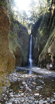
- Oneonta Gorge
-
The Oneonta Gorge is in the Columbia River Gorge in the American state of Oregon. The U.S. Forest Service has designated it as a botanical area because of the unique aquatic and woodland plants that grow there. The basalt walls are home to a wide variety of ferns, mosses, hepatics and lichens, many of which grow only in the Columbia River Gorge.
Oneonta Creek runs through the gorge. There are four major waterfalls on the creek. Middle Oneonta Falls can be seen clearly from a footpath and is very often mistaken for the upper or lower falls. The lower gorge has been preserved as a natural habitat, so there is no boardwalk or footpath through it as such. Thus, Lower Oneonta Falls can only be seen by walking upstream from the creek's outlet at the Historic Columbia River Highway. To get to a vantage point where the entire lower falls is visible can require wading through water that in some places can be chest-deep, depending on the season and the relative amount of snow-melt. The upper falls are about 1 mile upstream from the middle falls and require scrambling up the creek or climbing down a canyon wall to view. The fourth falls which is "Triple falls" can be seen from a vantage point on the upper trails in the canyon.
The Oneonta Gorge was first photographed by Carleton Emmons Watkins, a native of Oneonta, New York, who had traveled west during the time of California Gold Rush of 1849. Watkins named the Oneonta Falls after his hometown.[1]
References
- ^ "Oneonta/USA". Greater Oneonta Historical Society. http://www.oneontahistory.org/oneontausa.htm. Retrieved 2009-06-20.
External links
Coordinates: 45°35′22″N 122°04′31″W / 45.5895623°N 122.0753629°W
Waterfalls of Oregon Columbia Gorge - (west to east): Latourell Falls
- Bridal Veil Falls
- Coopey Falls
- Wahkeena Falls
- Fairy Falls
- Multnomah Falls
- Horsetail Falls
- Oneonta Gorge
- Wahclella Falls
- Camp Benson Falls
- Hole-in-the-Wall Falls
- Celilo Falls
- Eagle Creek
- (north to south): Wauna Falls
- Metlako Falls
- Lower Punch Bowl Falls
- Punch Bowl Falls
- Loowit Falls
- Skoonichuk Falls
- Tenas Falls
- Wy'east Falls
- Grand Union Falls
- Tunnel Falls
- Twister Falls
- Sevenmile Falls
Other areas - NW Oregon: Youngs River Falls
- Ki-a-Kuts Falls
- Willamette Valley: Willamette Falls
- Silver Falls State Park
- Shellburg Falls
- Salt Creek Falls
- Southern Cascades: Toketee Falls
- Watson Falls
- Mill Creek Falls
- Central Oregon: Benham Falls
- Dillon Falls
- Lava Island Falls
Categories:- Canyons and gorges of Oregon
- Columbia River Gorge
- Natural history of Oregon
- Waterfalls of Oregon
- Historic Columbia River Highway
- Landforms of Multnomah County, Oregon
- Mount Hood National Forest
- Multnomah County, Oregon geography stubs
Wikimedia Foundation. 2010.


