- Interstate 43
Infobox road
state=WI
type=I
route=43
maint=WisDOT 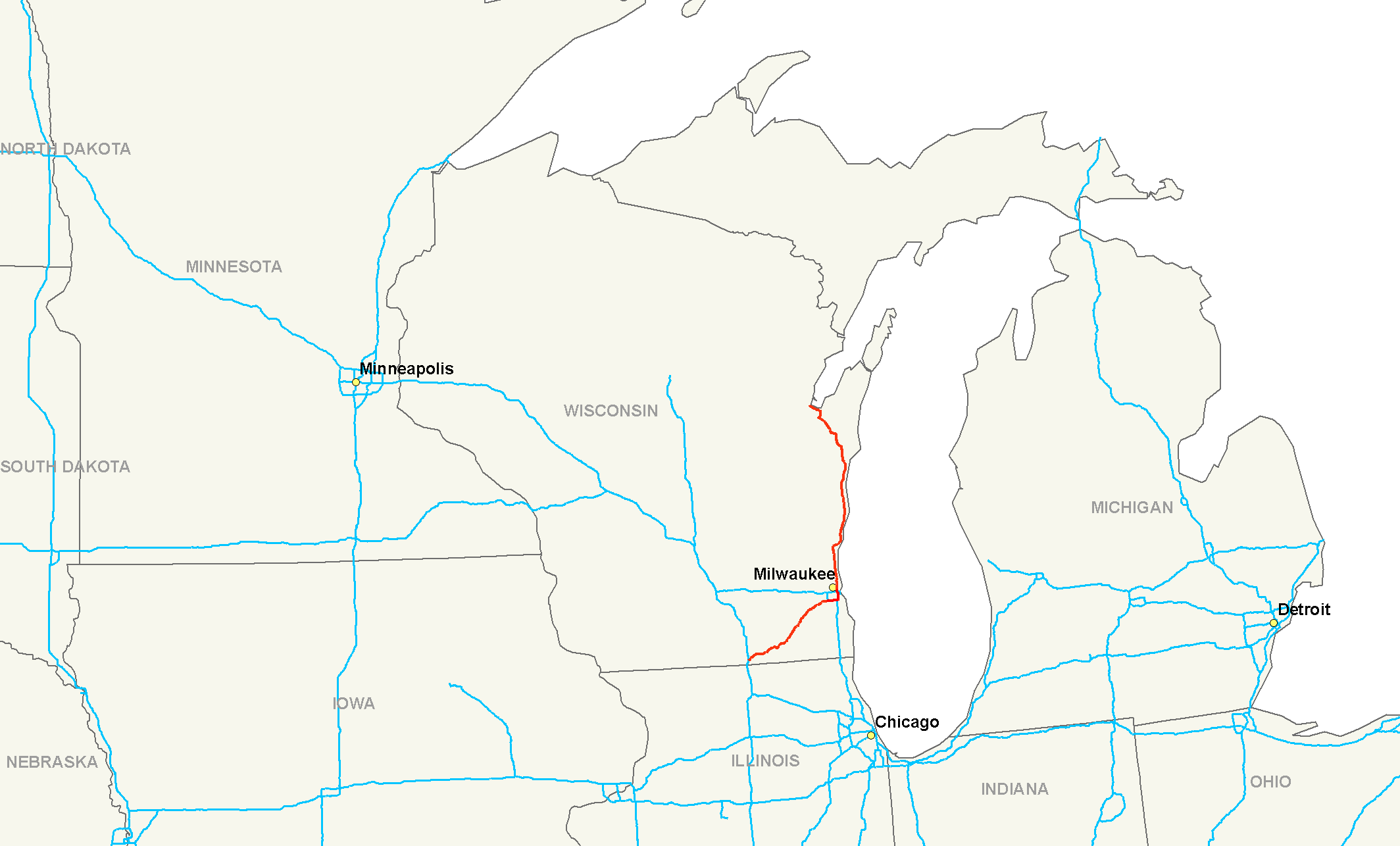
length_mi=191.55
length_round=2
length_ref=Fact|date=July 2008 [http://www.fhwa.dot.gov/reports/routefinder/table1.htm Interstate lengths] from theUnited States Department of Transportation ]
established=
direction_a=South
direction_b=North
terminus_a=Jct|state=WI|I|39|I|90|WI|81 inBeloit, WI
junction=Jct|state=WI|I|94 inMilwaukee, WI
terminus_b=Jct|state=WI|US|41|US|141 nearGreen Bay, WI
previous_type=WI
previous_route=42
next_type=WI
next_route=44
commons=categoryInterstate 43 (I-43) is an intrastate Interstate highway located entirely within the state of
Wisconsin . The highway connects Milwaukee with Green Bay, Manitowoc, and Sheboygan and points in between. The route also connects Elkhorn and Beloit with Milwaukee.Route description
I-43 begins in Rock County as the eastern leg of a
cloverleaf interchange with I-39/I-90 just east of Beloit. The highway becomesWisconsin Highway 81 west of the interchange. I-43 passes Clinton to the north at WIS 140 and passes into Walworth County five miles (8 km) east of WIS 140.cite map|url=http://www.dot.wisconsin.gov/travel/maps/docs/counties/rock.pdf | format=pdf | title=Rock Co | publisher=Wisconsin Department of Transportation | accessdate=2008-01-17] I-43 passes north of Darien and crosses US 14 at that point, then junctions with WIS 50 south of Delavan.In Elkhorn, I-43 junctions with WIS 67, US 12, and WIS 11. I-43 passes through East Troy about ten miles (16 km) northeast of Elkhorn and junctions with WIS 20 and
Wisconsin Highway 120 . I-43 then enters Waukesha County at Mukwonago.cite map|url=http://www.dot.wisconsin.gov/travel/maps/docs/counties/walworth.pdf | format=pdf | title=Walworth Co | publisher=Wisconsin Department of Transportation | accessdate=2008-01-17] I-43 crosses WIS 83 at an interchange just southeast of the village. After about eight miles (13 km), the highway junctions with WIS 164 just north of Big Bend, and then enters the city of Muskego. I-43 crosses interchanges with South Racine Avenue (CTH Y) and South Moorland Road (CTH O) in Muskego.Beginning in Muskego, I-43 is known as the Rock Freeway.cite map|url=http://maps.google.com/maps?f=q&hl=en&geocode=&time=&date=&ttype=&q=Muskego,+WI,+United+States+of+America&ie=UTF8&ll=42.931542,-88.128204&spn=0.076165,0.155182&z=13&om=0 | title=Muskego, WI, United States of America - Google Maps | publisher=Google | cartography=NAVTEQ | accessdate=2008-01-10] I 43 then passes into New Berlin and turns east to enter Milwaukee County.cite map|url=http://www.dot.wisconsin.gov/travel/maps/docs/counties/waukesha.pdf | format=pdf | title=Waukesha Co | publisher=Wisconsin Department of Transportation | accessdate=2008-01-17]
I-43 connects with US 45 south and WIS 100 at South 108th Street. US 45 joins I-43 for one mile (1.6 km), then turns northward onto I-894 west at the Hale Interchange while I-43 follows I-894 east along the Airport Freeway into
Greenfield, Wisconsin , crossing interchanges with WIS 24, WIS 36 and WIS 241 along the way. I-43 and I-894 junction with I-94 and US 41, known in Milwaukee as the North-South Freeway, at the Mitchell Interchange. I-43 follows the North-South Freeway (with I-94 and US 41) north into downtown Milwaukee, where it meets I-794 at theMarquette Interchange .I-43 continues north from the Marquette, while I-94 and US 41 turn westward. I-43 crosses WIS 145 at the McKinley Boulevard/Fond du Lac Avenue interchange. On the way north out of Milwaukee, I-43 passes through Glendale, junctioning with WIS 190 (Capitol Drive) and WIS 57 (Green Bay Ave). WIS 100 and WIS 32 connect at Brown Deer Road and WIS 32 follow I-43 north into
Ozaukee County, Wisconsin .cite web | last = Bessert | first = Chris | title =Wisconsin Highways: Milwaukee Freeway Map | work =Wisconsin Highways | url =http://www.wisconsinhighways.org/milwaukee/system_map.html | accessdate = 2008-01-17] cite map|url=http://www.dot.wisconsin.gov/travel/maps/docs/counties/milwaukee.pdf | format=pdf | title=Milwaukee Co | publisher=Wisconsin Department of Transportation | accessdate=2008-01-17]I-43 is joined by WIS 57 three miles (5 km) north of the county line in Mequon at the junction of
Wisconsin Highway 167 . WIS 60 terminates in Grafton at the interstate seven miles (11 km) further north and WIS 32 turns off toward Port Washington one mile (1.6 km) north of WIS 60. WIS 33 crosses the route in Saukville. WIS 57 turns north off the freeway, which turns eastward to go around Port Washington to the north. WIS 32 rejoins the freeway on the north side and I-43 and WIS 32 follow theLake Michigan shoreline northeast into Sheboygan County.cite map|url=http://www.dot.wisconsin.gov/travel/maps/docs/counties/ozaukee.pdf | format=pdf | title=Ozaukee Co | publisher=Wisconsin Department of Transportation | accessdate=2008-01-17] WIS 32 leaves the freeway at Cedar Grove and I-43 passes Oostburg to the east and Sheboygan, Wisconsin to the west. I-43 Sheboygan interchanges are at WIS 28, WIS 23, and WIS 42 I-43 enters Manitowoc County after nine miles (14 km) from Sheboygan.cite map|url=http://www.dot.wisconsin.gov/travel/maps/docs/counties/sheboygan.pdf | format=pdf | title=Sheboygan Co | publisher=Wisconsin Department of Transportation | accessdate=2008-01-17]I-43 passes Cleveland on the county line. The highway continues to follow the lakeshore to Manitowoc, then bypass the city to the west. I-43 connects with US 151 and WIS 42. WIS 42 north follow I-43 north to the interchange with US 10. WIS 42 leaves to the east along with US 10 east, and US 10 west follow I-43 north to the interchange with WIS 310 where it turns off to the west. I-43 passes Francis Creek and Maribel (at WIS 147) and turns northwestward into Brown County, with a
rest stop located just before the county line.cite map|url=http://www.dot.wisconsin.gov/travel/maps/docs/counties/manitowoc.pdf | format=pdf | title=Manitowoc Co | publisher=Wisconsin Department of Transportation | accessdate=2008-01-17] The interstate passes Denmark and meets the terminus of WIS 96 one mile (1.6 km) north of the county line. I-43 then continues another seven miles (11 km) to Bellevue where US 141 begins. This interchange provides access toWisconsin Highway 29 , a route I-43 crosses under later.I-43 junctions with WIS 172 in Allouez then turns northeast to bypass Green Bay to the east, passing under the aforementioned WIS 29. After turning northwestward, I-43 crosses WIS 54 and WIS 57 and the Fox River. I-43 ends at US 41 and US 141.cite map|url=http://www.dot.wisconsin.gov/travel/maps/docs/counties/brown.pdf | format=pdf | title=Brown Co | publisher=Wisconsin Department of Transportation | accessdate=2008-01-17]
History
The highway route that is now I-43 existed for several years prior to its designation as an Interstate highway. The section from its southern terminus to its intersection with I-894 in Milwaukee was originally designated Wisconsin STH 15. The section running from
Interstate 94 andInterstate 794 in Milwaukee to the northern terminus was originally designatedUS 141 . The latter section was the first designated as I-43. I-43 betweenInterstate 894 and the southern terminus is historically known as the "Rock Freeway," representing the freeway's link between Milwaukee and Rock County.The original plan for the northern part of I-43 was to locate it midway between US 141 (the former designation for the current I-43) and US 41, using most of the current alignment of Wisconsin STH 57 north of Wisconsin STH 33 in Saukville. But opposition to the plan prompted a compromise to utilize the freeway built for US 141 between Milwaukee and Sheboygan instead, building the remaining freeway for the interstate itself. The segment was completed in 1981. The southwestern segment's road was built between 1969 and 1972 from Big Bend to East Troy. It was extended to Elkhorn in 1973, then to I-90 in 1976. I-43 markers were placed on the freeway by 1991 after designation in 1987. Mileposts were renumbered to coincide with the current length by 1991.cite web | last = Bessert | first = Chris | title =Wisconsin Highways: Highways 40-49 (Interstate 43) | work =Wisconsin Highways | url =http://www.wisconsinhighways.org/listings/WiscHwys40-49.html#I-043 | accessdate = 2008-01-17]
Exit list
References
Wikimedia Foundation. 2010.